Atlas of Gabon: Difference between revisions
intro |
Mateus2019 (talk | contribs) m added Category:Gallery pages of Gabon |
||
| (23 intermediate revisions by 11 users not shown) | |||
| Line 1: | Line 1: | ||
{{atlas-country |
{{atlas-country |
||
|short name = Gabon |
|short name = Gabon |
||
|native = Gabon (French) |
|||
|long name = Gabonese Republic |
|long name = Gabonese Republic |
||
|map = |
|map = LocationGabon.svg |
||
|location = Central Africa |
|location = Central Africa |
||
|status = Independent country since 1960 |
|status = Independent country since 1960 |
||
| ⚫ | |||
| ⚫ | La '''République gabonaise''' est un pays à l'ouest de l'Afrique centrale très peu peuplé. Situé entre le Congo, la Guinée équatoriale et le Cameroun, c’est un pays forestier où la faune et la flore sont encore bien conservées. Anciennement impliqué dans le commerce triangulaire, puis colonie française, le Gabon est indépendant depuis 1960.}} |
||
|previous = Frenc possession |
|previous = Frenc possession |
||
|capital = Libreville |
|capital = Libreville |
||
|population = 1, |
|population = 1,811,079 |
||
|surface = 267,668 |
|surface = 267,668 |
||
|language = French |
|language = French (official), languages of the ethnic groups |
||
|religion = Roman Catholicism and Animism |
|religion = Roman Catholicism and Animism |
||
|intro = The '''Gabonese Republic''' is a country in west central Africa. It borders on Equatorial Guinea, Cameroon, Republic of the Congo and the Gulf of Guinea. A small population, abundant natural resources, and foreign private investment have helped make Gabon one of the most prosperous countries in the region. |
|intro = The '''Gabonese Republic''' is a country in west central Africa. It borders on {{atp|Equatorial Guinea}}, {{atp|Cameroon}}, {{atp|Republic of the Congo}} and the Gulf of Guinea with {{atp|São Tomé and Príncipe}}. A small population, abundant natural resources, and foreign private investment have helped make Gabon one of the most prosperous countries in the region. |
||
}} |
}} |
||
====In French==== |
|||
| ⚫ | |||
| ⚫ | |||
{{general-maps|country=Gabon}} |
{{general-maps|country=Gabon}} |
||
{{left|Image: |
{{left|Image:Carte_gabon.png|Carte du Gabon<p>Map of Gabon}} |
||
{{left|Image:Gabon Map.jpg|Carte du Gabon<p>Map of Gabon}} |
{{left|Image:Gabon Map.jpg|Carte du Gabon<p>Map of Gabon}} |
||
{{left|Image:Carte gabon.png|Même carte en français<p>Same map in French|150}} |
|||
{{left|Image:Gabun-karte-politisch.png|Carte politique<p>Political map (in German)}} |
{{left|Image:Gabun-karte-politisch.png|Carte politique<p>Political map (in German)}} |
||
{{history|Gabon}} |
{{history|Gabon}} |
||
{{left|Image:French Equatorial Africa.PNG|Afrique Équatoriale française<p>{{link|French Equatorial Africa}}}} |
{{left|Image:French Equatorial Africa.PNG|Afrique Équatoriale française<p>{{link|French Equatorial Africa}}}} |
||
{{region-maps|provinces and departments of Gabon}} |
{{region-maps|provinces and departments of Gabon}} |
||
{{left|Image:Gabon98-color.svg|Les provinces du Gabon (SVG)<p>{{link|Provinces of Gabon}}}} |
|||
{{left|Image:Gabon98.svg|Les provinces du Gabon (SVG, plus de précision)<p>{{link|Provinces of Gabon}}}} |
|||
{{left|Image:Gabon provinces named.png|Les provinces du Gabon<p>{{link|Provinces of Gabon}}}} |
{{left|Image:Gabon provinces named.png|Les provinces du Gabon<p>{{link|Provinces of Gabon}}}} |
||
{{left|Image:Departments of Gabon.png|Les départements du Gabon<p>{{link|Departments of Gabon}}}} |
{{left|Image:Departments of Gabon.png|Les départements du Gabon<p>{{link|Departments of Gabon}}}} |
||
| Line 35: | Line 34: | ||
Image:Nyanga departments.png|Départements de Nyanga |
Image:Nyanga departments.png|Départements de Nyanga |
||
Image:Ogooue-Ivindo departments.png|Départements d'Ogooué-Ivindo |
Image:Ogooue-Ivindo departments.png|Départements d'Ogooué-Ivindo |
||
Image: |
Image:Départements de l'Ogooué-Lolo.svg|Départements d'Ogooué-Lolo |
||
Image:Ogooue-Maritime departments.png|Départements d'Ogooué-Maritime |
Image:Ogooue-Maritime departments.png|Départements d'Ogooué-Maritime |
||
Image:Woleu-Ntem departments.png|Départements de Woleu-Ntem |
Image:Woleu-Ntem departments.png|Départements de Woleu-Ntem |
||
| Line 45: | Line 44: | ||
{{left|Image:Gabon BMNG.png|Carte satellite<p>Satellite map}} |
{{left|Image:Gabon BMNG.png|Carte satellite<p>Satellite map}} |
||
{{atlas-end|Gabon_sm04.png}} |
{{atlas-end|Gabon_sm04.png}} |
||
[[Category:Atlas of Africa]] |
[[Category:Atlas of Africa|Gabon]] |
||
[[Category:Maps of Gabon]] |
[[Category:Maps of Gabon]] |
||
| ⚫ | |||
[[Category:Atlas entries in progress fase 9]] |
[[Category:Atlas entries in progress fase 9]] |
||
| ⚫ | |||
[[af:Gaboen]] |
|||
[[am:ጋቦን]] |
|||
[[ar:الغابون]] |
|||
[[an:Gabón]] |
|||
[[ast:Gabón]] |
|||
[[bn:গ্যাবন]] |
|||
[[zh-min-nan:Gabon]] |
|||
[[bs:Gabon]] |
|||
[[bg:Габон]] |
|||
[[ca:Gabon]] |
|||
[[cs:Gabon]] |
|||
[[cy:Gabon]] |
|||
[[da:Gabon]] |
|||
[[de:Gabun]] |
|||
[[et:Gabon]] |
|||
[[en:Gabon]] |
|||
[[es:Gabón]] |
|||
[[eo:Gabono]] |
|||
[[eu:Gabon]] |
|||
[[fa:گابن]] |
|||
[[fr:Gabon]] |
|||
[[gl:Gabón - Gabon]] |
|||
[[ko:가봉]] |
|||
[[hr:Gabon]] |
|||
[[io:Gabon]] |
|||
[[id:Gabon]] |
|||
[[is:Gabon]] |
|||
[[it:Gabon]] |
|||
[[he:גבון]] |
|||
[[ka:გაბონი]] |
|||
[[kw:Gabon]] |
|||
[[sw:Gabon]] |
|||
[[la:Gabonia]] |
|||
[[lv:Gabona]] |
|||
[[lt:Gabonas]] |
|||
[[li:Gabon]] |
|||
[[hu:Gabon]] |
|||
[[ms:Gabon]] |
|||
[[nl:Gabon]] |
|||
[[ja:ガボン]] |
|||
[[no:Gabon]] |
|||
[[nn:Gabon]] |
|||
[[oc:Gabon]] |
|||
[[ug:گابون]] |
|||
[[pam:Gabon]] |
|||
[[ps:ګابون]] |
|||
[[nds:Gabun]] |
|||
[[pl:Gabon]] |
|||
[[pt:Gabão]] |
|||
[[ro:Gabon]] |
|||
[[ru:Габон]] |
|||
[[sa:गाबोन]] |
|||
[[sq:Gabonia]] |
|||
[[simple:Gabon]] |
|||
[[sk:Gabon]] |
|||
[[sl:Gabon]] |
|||
[[sr:Габон]] |
|||
[[fi:Gabon]] |
|||
[[sv:Gabon]] |
|||
[[tl:Gabon]] |
|||
[[th:ประเทศกาบอง]] |
|||
[[vi:Gabon]] |
|||
[[tg:Габон]] |
|||
[[tpi:Gabon]] |
|||
[[tr:Gabon]] |
|||
[[uk:Ґабон]] |
|||
[[vo:Gabunän]] |
|||
[[wo:Gaboŋ]] |
|||
[[yi:גאבאן]] |
|||
[[zh:加蓬]] |
|||
Latest revision as of 16:59, 21 April 2024

|
Wikimedia Commons Atlas of the World The Wikimedia Atlas of the World is an organized and commented collection of geographical, political and historical maps available at Wikimedia Commons. Discussion • Update the atlas • Index of the Atlas • Atlas in categories • Other atlases on line |
|
| ||||||||||||||||||||||||||||||||||||||||


General maps

|
Carte du Gabon Map of Gabon |

|
Carte du Gabon Map of Gabon |

|
Carte politique Political map (in German) |
History maps
This section holds a short summary of the history of the area of present-day Gabon, illustrated with maps, including historical maps of former countries and empires that included present-day Gabon.

|
Afrique Équatoriale française |
Maps of divisions
This section holds maps of the administrative divisions.

|
Les provinces du Gabon (SVG) |

|
Les provinces du Gabon (SVG, plus de précision) |

|
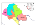
Les provinces du Gabon |

|
Les départements du Gabon |
.jpg)
|
Golfe de Guinée |
-
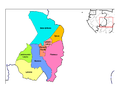
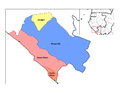
 Départements d'Estuaire
 -
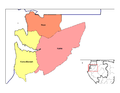
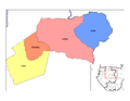
 Départements de Haut-Ogooué
 -
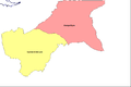 Départements de Moyen-Ogooué
 -
 Départements de Ngounié
 -
 Départements de Nyanga
 -
 Départements d'Ogooué-Ivindo
 -
 Départements d'Ogooué-Lolo
 -
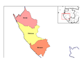 Départements d'Ogooué-Maritime
 -
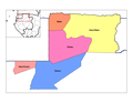 Départements de Woleu-Ntem


Ethnic maps (Cartes ethniques)

|
Maka-Njem éthinies (Ethnic groups) |
Satellite maps

|
Carte satellite Satellite map |

|
Carte satellite Satellite map |
Notes and references
|
General remarks:
|