File:Australia-states-timezones.png
From Wikimedia Commons, the free media repository
Revision as of 07:06, 4 July 2023 by Responsible? (talk | contribs) (Responsible? reverted File:Australia-states-timezones.png to an old version)

Size of this preview: 653 × 599 pixels. Other resolutions: 261 × 240 pixels | 523 × 480 pixels | 837 × 768 pixels | 1,116 × 1,024 pixels | 2,000 × 1,836 pixels.
Original file (2,000 × 1,836 pixels, file size: 210 KB, MIME type: image/png)
File information
Structured data
Captions
Captions
Add a one-line explanation of what this file represents
Summary
| DescriptionAustralia-states-timezones.png |
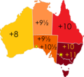
English: Time zone offsets from UTC (including daylight saving) across states and territories of Australia (excluding claimed Australian Antarctic Territory). |
||
| Date | |||
| Source | Own work, based on File:Australia states blank.svg | ||
| Author | Responsible?, D000A | ||
| Permission (Reusing this file) |
I, the copyright holder of this work, hereby publish it under the following licenses:
This file is licensed under the Creative Commons Attribution-Share Alike 4.0 International, 3.0 Unported, 2.5 Generic, 2.0 Generic and 1.0 Generic license.
You may select the license of your choice. |
||
| Other versions |
Original maps:  , ,  |
Color Legend
| Standard | DST | Zone | States/territories | |
|---|---|---|---|---|
| UTC+06:30 (year round) | Cocos | CC | ||
| UTC+07:00 (year round) | Christmas | CX | ||
| UTC+08:00 (year round) | Western | WA | ||
| UTC+09:30 (year round) | Central | NT | ||
| UTC+09:30 | UTC+10:30 | Central | SA, Broken Hill | |
| UTC+10:00 (year round) | Eastern | QLD | ||
| UTC+10:00 | UTC+11:00 | Eastern | NSW, TAS, Macquarie Island, VIC, ACT, JBT | |
| UTC+11:00 | UTC+12:00 | Norfolk | NF | |
File history
Click on a date/time to view the file as it appeared at that time.
| Date/Time | Thumbnail | Dimensions | User | Comment | |
|---|---|---|---|---|---|
| current | 07:06, 4 July 2023 |  | 2,000 × 1,836 (210 KB) | Responsible? (talk | contribs) | Reverted back to the original -- the intent of this map is to depict Australia, not a much wider area that may be "Australian" politically but not geographically. That just ruins the original & makes an ocean map that's hard to read. Please don't do that. I will upload D000A's version as a separate file. |
| 09:26, 15 April 2023 |  | 1,930 × 1,450 (203 KB) | Vanished user f37815adc29f052df1d76cfb358a06fa (talk | contribs) | updated to inhabited states and territories only https://www.australia.gov.au/time-zones-and-daylight-saving | |
| 08:26, 15 April 2023 |  | 2,134 × 1,604 (234 KB) | Vanished user f37815adc29f052df1d76cfb358a06fa (talk | contribs) | Time zones across States and territories of Australia (excluding claimed Australian Antarctic Territory) | |
| 02:11, 4 August 2012 |  | 2,000 × 1,836 (210 KB) | Responsible? (talk | contribs) | Made suns clearer | |
| 08:02, 2 August 2012 |  | 2,000 × 1,836 (209 KB) | Responsible? (talk | contribs) | Re-uploaded | |
| 07:44, 2 August 2012 |  | 2,000 × 1,836 (209 KB) | Responsible? (talk | contribs) |
You cannot overwrite this file.
File usage on Commons
The following 3 pages use this file:
Metadata
This file contains additional information such as Exif metadata which may have been added by the digital camera, scanner, or software program used to create or digitize it. If the file has been modified from its original state, some details such as the timestamp may not fully reflect those of the original file. The timestamp is only as accurate as the clock in the camera, and it may be completely wrong.
| Horizontal resolution | 37.8 dpc |
|---|---|
| Vertical resolution | 37.8 dpc |
