Approach to Base Camp: Spend some days in Kathmandu, while here check gear, meet the Sherpa and also prepare for your flight to Lukla (9,000ft) that is the main point, from where you will begin your trek to Everest Base Camp.
The 16 day Everest Kalapathar Trekking route takes you through richly cultured and quite fascinating villages like Phakding, Namche Bazaar,Tengboche,Dingboche, Luboche,Gorakshep to the Everest Base Camp.
Base Camp: Trekkers will spend couple of weeks at the Everest Base Camp for acclimatizing to the altitude. In the mean time Sherpas & expert expedition climbers set up ladders & ropes in the treacherous Khumbu Icefall which is well-known for its shifting ice blocks, crevasses & seracs. In order to reduce the occurrence of any hazards at this most dangerous section of the route, sherpas usually prefer to begin their ascent atop the mountain well before dawn as during this time the ice blocks stay glued together because of freezing temperatures.
Camp I & Camp II: Climb to Camp I, located right above the icefall at 6,065 meters (19,900 ft). From Camp I, continue climbing up to Camp II or the Advanced Base Camp (ABC), which is established at 21,000ft in the Western Cwm. This flat and gently rising glacial valley is ideally marked by huge lateral crevasses in the centre that prevent direct access to the upper reaches of the Cwm, thus the climbers need to cross on the far right near the base of Nuptse to a small passageway that is widely known as the "Nuptse corner". Camp II will be your base during the placements of Camp III and Camp IV.
Camp III & IV: From Camp II, climbers climb the Lhotse face through fixed ropes up to Camp III, situated on a small ledge at 7,470 m (24,500 ft). This is an intermediate camp that will help you to reach Camp IV, which is located on the South Col at 7,920 m (26,000 ft). While climbing from Camp III to Camp IV, you will be faced with two additional challenges: The Geneva Spur and The Yellow Band. The Geneva Spur - Named by the 1952 Swiss expedition, it is an anvil shaped rib of black rock, where in the fixed ropes help climbers in scrambling. The Yellow Band: This is the section of phyllite, interlayered marble, and semischist and so climbers require about 100 meters of rope to cross it.
Note that, on the South Col, you will enter the death zone, where you will have maximum two or three days to decide whether or not to make summit bids. The most critical factors in deciding about this attempt are clear weather and low winds. In case the weather does not favor you within this period then you may certainly be forced to descend all the way back down to the Base Camp.
But, if the weather is fine and favors you to continue with the Everest trekking, then you can certainly begin your summit push around midnight hoping to reach the summit within a period of 10 to 12 hours. While climbing, you will first reach "The Balcony" at 8,400 m (27,600 ft), which is a small platform, where you can take some rest and grab the breathtaking views of the peaks. You will be then continuing the trek and faced with a series of imposing rock steps, which will force you to the east into the west deep snow that is a serious avalanche hazard. Then at 8,750 m (28,700 ft), a small table-sized dome of ice and snow marks the South Summit.
From the South Summit, follow the knife-edge southeast ridge along the "Cornice traverse" where snow clings to intermittent rock. Since in this section, a misstep to the left would send one 2,400 m (8,000 ft) down the southwest face while to the immediate right is the 3,050 m (10,000 ft) Kangshung face, it is considered the most exposed section of the climb. Then, right at the end of this traverse, comes a striking 12 m (40 ft) rock wall at 8,760 m (28,740 ft), which is widely known as "Hillary Step".
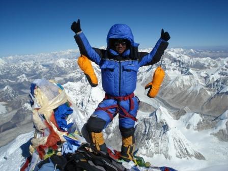
After arrival at the Hillary Step, if weather permits cross a loose and rocky section with large entanglement of fixed ropes to reach main peak, where you can spend just less than half-hour and then descend to Camp IV before darkness sets in because the afternoon weather often becomes a serious problem for trekkers. |