El Niño & La Niña
- 1. El Niño & La Niña PowerPoint Presentation Prepared By: Clarence Marollano & Princess Jarme
- 2. EL NIÑO-SOUTHERN OSCILLATION (ENSO) CYCLE. El Niño and La Niña are opposite phases of what is known as the El Niño-Southern Oscillation (ENSO) cycle. The ENSO cycle is a scientific term that describes the fluctuations in temperature between the ocean and atmosphere in the east-central Equatorial Pacific (approximately between the International Date Line and 120 degrees West). La Niña is sometimes referred to as the cold phase of ENSO and El Niño as the warm phase of ENSO. These deviations from normal surface temperatures can have large-scale impacts not only on ocean processes, but also on global
- 3. El Niño and La Niña episodes typically last nine to 12 months, but some prolonged events may last for years. They often begin to form between June and August, reach peak strength between December and April, and then decay between May and July of the following year. While their periodicity can be quite irregular, El Niño and La Niña events occur about every three to five years. Typically, El Niño occurs more frequently than La Niña.
- 4. What is El Niño? • El Niño means The Little Boy, or Christ Child in Spanish. • El Niño was originally recognized by fishermen off the coast of South America in the 1600s, with the appearance of unusually warm water in the Pacific Ocean. The name was chosen based on the time of year (around December) during which these warm waters events tended to occur. • The term El Niño refers to the large-scale ocean- atmosphere climate interaction linked to a periodic warming in sea surface temperatures across the central and east-central Equatorial Pacific.
- 5. • Typical El Niño effects are likely to develop over North America during the upcoming winter season. Those include warmer-than-average temperatures over western and central Canada, and over the western and northern United States. Wetter-than-average conditions are likely over portions of the U.S. Gulf Coast and Florida, while drier-than- average conditions can be expected in the Ohio Valley and the Pacific Northwest.
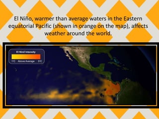
- 6. El Niño, warmer than average waters in the Eastern equatorial Pacific (shown in orange on the map), affects weather around the world.
- 7. The First Signs of an El Niño: • Rise in air pressure in the Indian Ocean, Indonesia, and Australia. • A fall in air pressure over Tahiti and the rest of central and eastern Pacific Ocean. • The trade winds in the South Pacific weakened or headed east • Warm air rises in Peru • Warm water spreads from the West Pacific and the Indian Ocean to the East Pacific. It takes the rain with it, causing rainfall in normally dry areas and drought in normally wet areas.
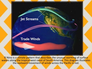
- 8. El Nino is a climate pattern that describes the unusual warming of surface waters along the tropical west coast of South America. This diagram illustrates the eastward movement of winds across the Pacific in red.
- 9. The Effects of El Niño: • Wet winters over south-eastern United States • Drought in Indonesia and Australia, and other places that are typically wet • Flood in South America in areas that are typically dry • Wildfires and mudslides • Warmer weather in the upper Midwest states and Canada
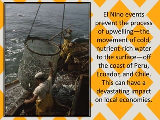
- 10. El Nino events prevent the process of upwelling—the movement of cold, nutrient-rich water to the surface—off the coast of Peru, Ecuador, and Chile. This can have a devastating impact on local economies.
- 11. El Nino events often result in unusual and destructive weather patterns. The normally arid climate of the tropical South American coast, for instance (here, in Chile) may experience floods and landslides during El Nino events.
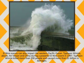
- 12. El Nino events can also impact the western Pacific Ocean. Typhoon Winnie, above, hit Taiwan and China during a powerful El Nino event in 1997. Typhoon Winnie killed more than 200 people and caused more than $1 billion in damages.
- 13. Australia is often plagued by drought during strong El Nino events. Here, Lake Alexandrina, a large lake in southern Australia, is almost dried up.
- 14. How Well Can We Predict El Niño? • Satellite readings from buoys strategically set in the Pacific Ocean • Complex computer models
- 15. What is La Niña? • La Niña means The Little Girl in Spanish. • La Niña is also sometimes called El Viejo, anti-El Niño, or simply “a cold event”. • La Niña episodes represent periods of below-average sea surface temperatures across the east-central Equatorial Pacific. Global climate La Niña impacts tend to be opposite those of El Niño impacts. In the tropics, ocean temperature variations in La Niña also tend to be opposite those of El Niño. • During a La Niña year, winter temperatures are warmer than normal in the Southeast and cooler than normal in the Northwest
- 16. La Niña is caused by a build-up of cooler-than-normal waters in the tropical Pacific, the area of the Pacific Ocean between the Tropic of Cancer and the Tropic of Capricorn. Unusually strong, eastward-moving trade winds and ocean currents bring this cold water to the surface, a process known as upwelling.
- 17. The First Signs of a La Niña: The first signs of an emerging La Niña event are often observed in the ocean. The Bureau of Meteorology monitors and reports on a range of ENSO indicators, including: • Short-term bursts of tropical rainfall activity • Water temperatures at the sea surface and at depth • Ocean heat content – measuring the amount of energy stored in the ocean • The Southern Oscillation Index • Atmospheric air pressure • Cloudiness – measuring the amount of cloud in tropical regions • The strength of the trade winds and winds higher in the atmosphere ocean currents
- 18. The weather pattern known as La Nina brings warmer-than-normal sea-surface temperatures (in red) to the southern Pacific Ocean around northern Australia, New Guinea, and the islands of Indonesia. The cooler sea-surface temperatures of La Nina (in blue) occur in the southern Pacific off the coast of South America.
- 19. The Effects of La Niña: • Rain clouds form as a result of the uplift of warm, moist air. • Monsoon seasons will be more intense in a La Nina year. • Western equatorial portions of South America may be in drought conditions. • In the United States, Washington and Oregon may see increased precipitation. • Portions of California, Nevada, and Colorado may see drier conditions.
- 20. A group of scouts uses a disassembled cardboard box as protection against a heavy rainstorm in Semarang, Java, Indonesia. La Nina events often bring wetter-than-normal weather to Indonesia, northern Australia, and Malaysia.
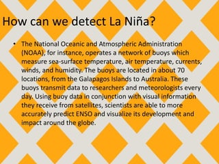
- 21. How can we detect La Niña? • The National Oceanic and Atmospheric Administration (NOAA), for instance, operates a network of buoys which measure sea-surface temperature, air temperature, currents, winds, and humidity. The buoys are located in about 70 locations, from the Galapagos Islands to Australia. These buoys transmit data to researchers and meteorologists every day. Using buoy data in conjunction with visual information they receive from satellites, scientists are able to more accurately predict ENSO and visualize its development and impact around the globe.
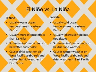
- 22. El Niño vs. La Niña El Niño • Usually warm ocean temperatures in eastern Pacific • Usually more intense effect than La Niña • Summers in Omaha tends to be wetter and cooler • Causes drier weather on West Pacific seaboards and wetter, humid weather in East Pacific La Niña • Usually cold ocean temperatures in eastern Pacific • Usually follows El Niño but not always • Summers in Omaha tends to be drier and warmer • Causes wetter weather on West Pacific seaboards and drier weather in East Pacific
- 23. El Niño vs. La Niña El Niño • Warmer winters in the upper Midwest states and Canada • Wet winters over south- eastern United States La Niña • Colder winters in the upper Midwest states and Canada • Dry winters over south- eastern United States


