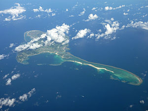
Kume Island
Island within Ryukyu Islands From Wikipedia, the free encyclopedia
Island within Ryukyu Islands From Wikipedia, the free encyclopedia
Kume Island[1] (久米島, Kumejima, Okinawan: クミジマ Kumijima) is an island, part of the Okinawa Islands and administratively part of the town of Kumejima, Okinawa Prefecture, Japan. It has an area of 59.11 square kilometres (636,300,000 sq ft).[2] The island had a population of 8,713 (2010).
Native name: クミジマ(Kumijima) | |
|---|---|
 Kumejima Island 2009 | |
 | |
| Geography | |
| Location | Pacific Ocean |
| Coordinates | 26°20′28″N 126°48′18″E |
| Archipelago | Okinawa Islands |
| Area | 59.11 km2 (22.82 sq mi) |
| Administration | |
Japan | |
| Prefecture | Okinawa Prefecture |
| Demographics | |
| Population | 8,713 (2010) |
| Ethnic groups | Ryukyuan, Japanese |
Kume Island is a volcanic island. Its principal economic activities are the production of sugarcane and tourism.[3]
| Climate data for Kumejima (1991−2020 normals, extremes 1958−present) | |||||||||||||
|---|---|---|---|---|---|---|---|---|---|---|---|---|---|
| Month | Jan | Feb | Mar | Apr | May | Jun | Jul | Aug | Sep | Oct | Nov | Dec | Year |
| Record high °C (°F) | 27.4 (81.3) |
27.0 (80.6) |
28.7 (83.7) |
30.2 (86.4) |
32.1 (89.8) |
33.7 (92.7) |
34.7 (94.5) |
35.3 (95.5) |
34.5 (94.1) |
32.7 (90.9) |
30.2 (86.4) |
29.4 (84.9) |
35.3 (95.5) |
| Mean daily maximum °C (°F) | 19.5 (67.1) |
20.0 (68.0) |
21.8 (71.2) |
24.3 (75.7) |
27.0 (80.6) |
29.9 (85.8) |
32.0 (89.6) |
31.8 (89.2) |
30.5 (86.9) |
27.9 (82.2) |
24.9 (76.8) |
21.4 (70.5) |
25.9 (78.6) |
| Daily mean °C (°F) | 17.0 (62.6) |
17.3 (63.1) |
19.0 (66.2) |
21.5 (70.7) |
24.2 (75.6) |
27.2 (81.0) |
29.0 (84.2) |
28.9 (84.0) |
27.7 (81.9) |
25.3 (77.5) |
22.4 (72.3) |
19.0 (66.2) |
23.2 (73.8) |
| Mean daily minimum °C (°F) | 14.6 (58.3) |
14.8 (58.6) |
16.3 (61.3) |
19.0 (66.2) |
21.8 (71.2) |
25.1 (77.2) |
26.7 (80.1) |
26.5 (79.7) |
25.3 (77.5) |
23.2 (73.8) |
20.3 (68.5) |
16.6 (61.9) |
20.8 (69.5) |
| Record low °C (°F) | 2.9 (37.2) |
4.0 (39.2) |
3.2 (37.8) |
6.8 (44.2) |
12.9 (55.2) |
16.4 (61.5) |
20.4 (68.7) |
19.8 (67.6) |
15.5 (59.9) |
11.6 (52.9) |
9.0 (48.2) |
5.4 (41.7) |
2.9 (37.2) |
| Average precipitation mm (inches) | 138.3 (5.44) |
141.2 (5.56) |
195.5 (7.70) |
196.8 (7.75) |
260.3 (10.25) |
307.4 (12.10) |
154.4 (6.08) |
197.7 (7.78) |
235.6 (9.28) |
152.7 (6.01) |
129.6 (5.10) |
134.0 (5.28) |
2,243.5 (88.33) |
| Average precipitation days (≥ 1.0 mm) | 12.7 | 11.7 | 13.0 | 11.5 | 12.0 | 11.2 | 7.9 | 9.8 | 10.6 | 8.6 | 9.0 | 10.7 | 128.7 |
| Average relative humidity (%) | 68 | 70 | 73 | 76 | 80 | 84 | 80 | 80 | 78 | 73 | 70 | 68 | 75 |
| Mean monthly sunshine hours | 75.2 | 80.1 | 107.6 | 118.4 | 136.2 | 158.9 | 250.3 | 231.9 | 198.6 | 162.3 | 108.3 | 89.9 | 1,717.8 |
| Source: Japan Meteorological Agency[4][5] | |||||||||||||
Seamless Wikipedia browsing. On steroids.
Every time you click a link to Wikipedia, Wiktionary or Wikiquote in your browser's search results, it will show the modern Wikiwand interface.
Wikiwand extension is a five stars, simple, with minimum permission required to keep your browsing private, safe and transparent.