Loading AI tools
Human settlement in England From Wikipedia, the free encyclopedia
Ludham is a village and civil parish in the English county of Norfolk, in the Norfolk Broads, at the end of a dyke leading to Womack Water and flowing into the River Thurne. It lies 1.5 miles (2.4 km) to the East of Ludham Bridge, which is on the River Ant. It covers an area of 12.18 km2 (4.70 sq mi) and had a population of 1,301 in 582 households at the 2001 census,[1] the population reducing to 1,278 at the 2011 census.[2] For the purposes of local government, it falls within the district of North Norfolk.

| Ludham | |
|---|---|
 Ludham village sign | |
Location within Norfolk | |
| Area | 12.18 km2 (4.70 sq mi) |
| Population | 1,278 (2011) |
| • Density | 105/km2 (270/sq mi) |
| OS grid reference | TG389183 |
| Civil parish |
|
| District | |
| Shire county | |
| Region | |
| Country | England |
| Sovereign state | United Kingdom |
| Post town | GREAT YARMOUTH |
| Postcode district | NR29 |
| Dialling code | 01692 |
| Police | Norfolk |
| Fire | Norfolk |
| Ambulance | East of England |
The villages name origin is unsure possibly, 'Luda's homestead/village' but perhaps, 'homestead/village on the Hlude (= noisy one)', an old name for Womack Water.
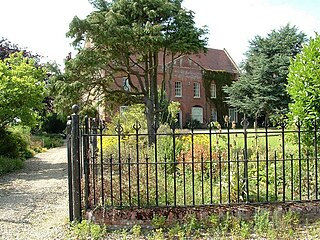
Ludham Hall was the former bishop's palace with a chapel now used as a barn. A palace of Bishops of Norwich it burnt down in 1611, and was rebuilt by Bishop Samuel Harsnett, with the chapel added 1627. The house of flint with ashlar quoins and some brick was refaced in the late 18th century in brick.[3][4]
It is part of the Ludham - Potter Heigham NNR, a national nature reserve.
The village gave its name to a Ham-class minesweeper, HMS Ludham and also, in geology, to an age/stage (the Ludhamian) in the British regional subdivision of the Pleistocene Series/Epoch. It also effectively gives its name to the preceding age/underlying stage known as the Pre-Ludhamian.[5]
The airfield at Ludham was built by Richard Costain Ltd and became operational in November 1941 as a second satellite for the main fighter station at RAF Coltishall sited north of Norwich, three tarmac-covered concrete runways and ancillary buildings being built on the land which had belonged to Fritton Farm. A total of ten RAF fighter squadrons (eight flying various marks of Supermarine Spitfire and two flying the Hawker Typhoon 1b) were based here between December 1941 and July 1945.
Ludham was one of the film locations for the 1954 movie Conflict of Wings starring John Gregson and Muriel Pavlow. Adapted from the novel by Don Sharp, the story takes place in a Norfolk country village where the locals decide to fight against a proposal to build an air-firing range on an island used as a bird sanctuary.[6]
Filming took place in the village centre, and shows many buildings and features (including the Bakers Arms pub and the very narrow main road through the village) which no longer exist.
A photograph showing filming and more information about Ludham can be accessed at the Ludham Community Archive website.
Seamless Wikipedia browsing. On steroids.
Every time you click a link to Wikipedia, Wiktionary or Wikiquote in your browser's search results, it will show the modern Wikiwand interface.
Wikiwand extension is a five stars, simple, with minimum permission required to keep your browsing private, safe and transparent.