Penge
Suburb of south-east London From Wikipedia, the free encyclopedia
Suburb of south-east London From Wikipedia, the free encyclopedia
Penge (/pɛndʒ/) is a suburb of South East London, England, now in the London Borough of Bromley, 3.5 miles (5.6 km) west of Bromley, 3.7 miles (6.0 km) north east of Croydon and 7.1 miles (11.4 km) south east of Charing Cross.
| Penge | |
|---|---|
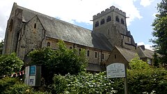
 Congregational Church, Penge | |
Location within Greater London | |
| OS grid reference | TQ345705 |
| • Charing Cross | 7.1 mi (11.4 km) NNW |
| London borough | |
| Ceremonial county | Greater London |
| Region | |
| Country | England |
| Sovereign state | United Kingdom |
| Post town | LONDON |
| Postcode district | SE20 |
| Dialling code | 020 |
| Police | Metropolitan |
| Fire | London |
| Ambulance | London |
| UK Parliament | |
| London Assembly | |

The name Penge is first attested in charter of 1067, as penceat, and in a twelfth-century copy of a charter of 957 as pænge (where the place is described as a "wood" (Old English: wudu, and in which King Eadwig gives Penge Common to the thane Lyfing). The name comes from the Common Brittonic words that survive in modern Welsh as pen ("head, end, summit") and coed ("woodland"), and thus it once meant "end of the wood", like a number of similar names, including Pencoed in Wales.[1]
The largest amosite mine in the world, in South Africa, was named Penge apparently because one of the British directors thought the two areas were similar in appearance.[2]
Penge was once a small hamlet attached to the manor of Battersea; it became independent from the manor in 1888.[1]
Penge was an inconspicuous area with few residents before the arrival of the railways. A traveller passing through Penge would have noticed the large common with a small inn on its boundary. Penge Green appears as Pensgreene on Kip's 1607 map.[3] The green was bounded to the north by Penge Lane, the west by Beckenham Road and the southeast by the Crooked Billet. On a modern map that is a very small area, but the modern-day Penge Lane and Crooked Billet are not in their original locations, and Beckenham Road would have been little more than a cart track following the property line on the west side of Penge High Street. Penge Lane was the road from Penge to Sydenham which is now named St John's Road and Newlands Park. There was also an old footpath crossing the Green leading to Sydenham, that was known as Old Penge Lane. After the London, Chatham and Dover Railway was built, Penge Lane crossed the line by level crossing. When this crossing was closed, Penge Lane was renamed and Old Penge Lane became the present-day Penge Lane.
The 1868 Ordnance Survey map shows the Old Crooked Billet located to the southeast of the current location. This earlier location was on the eastward side of Penge Green, which disappeared as a result of the Penge Enclosure Act, 1827 which enclosed the whole Green. This left the Crooked Billet with no frontage to Beckenham Road; hence, new premises were constructed on the present site in 1827, and subsequently replaced in 1840 with a three-storey building. This was severely damaged by enemy action in the Second World War, and subsequently rebuilt.[4]

The Crooked Billet (pictured above) is by far the oldest public house in Penge. Peter Abbott[5] states that it was there in 1601, and speculates that it might be much more ancient. In modern times it is particularly well known for lending its name to a bus route terminus. From 1914, General Omnibus routes 109 and 609 operated, along different paths, between Bromley Market and the Crooked Billet. The 109 was renumbered 227 by London Transport, and continued to terminate at the Crooked Billet. (Route 609 was shortened, terminating in Beckenham). Around 1950, some services were extended past the Crooked Billet to Crystal Palace. Eventually nearly all buses travelled the extended route. The 354 buses now use the terminus, as do short-running buses on routes 194 and 358.

William Hone wrote about a visit to the Crooked Billet in 1827[6] and included a detailed sketch of the last building on the original site.
The London and Croydon Canal was built across Penge Common along what is now the line of the railway through Penge West railway station, deviating to the south before Anerley railway station. There is a remnant at the northern corner of Betts Park, Anerley.[7] Following the closure of the canal, the London and Croydon Railway was built largely along the same course, opening in 1839. Isambard Kingdom Brunel built an atmospheric railway along this alignment as far as Croydon. The Crystal Palace pneumatic railway, which ran underground between the Sydenham and Penge entrances to Crystal Palace Park, operated for a short while but proved not to be economically viable.
In the Victorian era, Penge developed into a fashionable suburb because of the railway line and its proximity to the relocated Crystal Palace. It became a fashionable day out to visit the Crystal Palace during the day and to take the tram down the hill to one of the 'twenty-five pubs to the square mile'[8] that Penge was reputed to possess, or the two music halls—The King's Hall (later the Gaumont cinema) and, established in 1915, the Empire Theatre (later the Essoldo cinema).[9][10]
By 1862, Stanford's map of London and its Suburbs[11] shows large homes had been constructed along Penge New Road (now Crystal Palace Park Road, Sydenham and Penge High Street), Thick Wood (now Thicket) Road and Anerley Road.[12] This all came to an end in 1875 and 1877, with the notorious Penge murders. In 1875 Frederick Hunt murdered his wife and children,[13] then in 1877 a wealthy heiress, Harriet Staunton, together with her infant son, was starved to death by her husband and his associates.[14] In 1934, Elizabeth Jenkins published the novel Harriet, based on the case,[15] whilst Forbes Road was renamed to Mosslea Road because of its connection with the murders.
Penge formed a part of the parish of Battersea, with the historic county boundary between Kent and Surrey forming its eastern boundary.[16] In 1855 both parts of the parish were included in the area of the Metropolitan Board of Works, with Penge Hamlet Vestry electing six members to the Lewisham District Board of Works.[17] The Local Government Act 1888 abolished the Metropolitan Board, with its area becoming the County of London. However, the London Government Act 1899 subsequently made provision for Penge to be removed from the County of London and annexed to either Surrey or Kent. Accordingly, an Order in Council transferred the hamlet to Kent in 1900, constituting it as Penge Urban District.[18] The urban district was abolished in 1965 by the London Government Act 1963, and its former area merged with that of other districts to form the London Borough of Bromley. With the creation of the Penge Urban District, Penge New Road (formerly the part of Beckenham Road north of Kent House Road) was renamed Penge High Street.

The urban district comprised three sub-districts: Anerley, Penge and Upper Norwood.[19] It incorporated the whole of Crystal Palace Park except for part of the eastern side running along Crystal Palace Park Road which was then administered by Beckenham Urban District.[20] From 1885, the Hamlet of Penge was part of the Dulwich parliamentary constituency, which was then in Surrey, and remained in that seat until 1918, when it was transferred to the new Bromley constituency. From 1950, it was part of the Beckenham constituency. At the 2010 general election, Penge formed part of the Lewisham West and Penge constituency. In 2024 it again changed to become part of the new Beckenham and Penge constituency.[21] In local government, Penge is contained in the Penge and Cator ward, which had a population of 17,326 in 2011.
Closed pubs include The Golden Lion, Kent House Tavern, Robin Hood (closed, subsequently destroyed by fire in 2006 and demolished), Royal Oak (closed 2011), Queen Adelaide Arms (closed 2010), The Mitre (closed 2018), The Goat House (destroyed by fire and now demolished), The Waterman's Arms (now Superdrug), The Anchor (closed circa 1910), The General Simpson, The General Jackson, The Retreat, The Cornish Arms, The Railway Bell, The Thicket Tavern, The Paxton and Hollywood East (closed 2017) (formerly The Park Tavern). The last-named was the venue for the 1877 inquest into the murder of Harriet Staunton.
Fragments of the original Penge Common still survive in Betts Park. Winsford Gardens[25] formed part of the grounds of Chesham Park and later Winsford House.
Penge West station is served by London Overground services to Dalston Junction, Highbury & Islington and West Croydon. The former National Rail services to London Bridge, East Croydon and points south have been discontinued post Covid-19, although there is a campaign to have them reinstated.
Penge East and Kent House also serve the area with National Rail services to London Victoria, Bromley South and Orpington. Services may occasionally be extended beyond Orpington to Sevenoaks.
Penge is served by London Buses routes 75, 176, 194, 197, 227, 354, 356, 358 and N3. These connect it with areas including Beckenham, Bromley, Camberwell, Catford, Central London, Croydon, Crystal Palace, Dulwich, Elephant & Castle, Elmers End, Farnborough, Forest Hill, Lewisham, Orpington, Peckham, Shirley, South Norwood, Sydenham and West Wickham.
Three A roads, the A213, A214 and A234 pass through the area. The A213 intersects with the A234 at the Pawleyne Arms and the A214 at the Robin Hood.
Avenue Road is located on the southern tip of Penge and provides transport links to Wimbledon, Beckenham and Croydon.
St Johns C.E. Primary School was originally part of the Old Penge Chapel, which opened in 1837. Early in the 1850s, following the completion of St John the Evangelist, the school took over the entire old chapel building. The school's site was extended in 1977, and a new school building was opened in September 1978.[30]
The Beckenham and Penge County Grammar School for boys, formerly the Beckenham Technical Institute which opened in 1901, moved to a new site on Penge High Street between Kent House Road and Kingsdale Road in 1931. It moved from Penge to its present location in Eden Park, Beckenham, in January 1969.

St John the Evangelist's Church, Penge (pictured right) in Beckenham Road, was built in 1850 to designs by Edwin Nash & J. N. Round.[27] Penge Congregational Church was built in 1912 to designs by P. Morley Horder with passage aisles and clerestory, shafts on large, excellently carved corbels,[27] and a stained glass window by William Morris.
Crystal Palace Park contains the National Sports Centre, which includes an international-class athletic stadium, and a former motorsport circuit that was used in the 1969 film The Italian Job.[31] The Crystal Palace Park once housed a football ground, which hosted the FA Cup final from 1895[32] to 1914, as well as London County Cricket Club games from 1900 to 1908, when the club folded, and Crystal Palace FC's matches from their formation in 1905 until the club was forced to relocate during the First World War. Other facilities include Alexandra Recreation Ground, Penge Recreation Ground and Royston Playing Fields.
After the Crystal Palace was moved to Penge Place, a fashionable day out was to visit the Crystal Palace during the day and to take the tram down the hill to one of the 'twenty-five pubs to the square mile'[22] or two Music Halls.
Seamless Wikipedia browsing. On steroids.
Every time you click a link to Wikipedia, Wiktionary or Wikiquote in your browser's search results, it will show the modern Wikiwand interface.
Wikiwand extension is a five stars, simple, with minimum permission required to keep your browsing private, safe and transparent.