Herndon, Pennsylvania
Submit your own pictures of this borough and show them to the world
- OSM Map
- General Map
- Google Map
- MSN Map

Population change since 2000: -9.4%
| Males: 188 | |
| Females: 159 |
| Median resident age: | 47.6 years |
| Pennsylvania median age: | 41.1 years |
Zip codes: 17830.
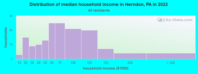
| Herndon: | $75,147 |
| PA: | $73,824 |
Estimated per capita income in 2023: $33,677 (it was $23,156 in 2000)
Herndon borough income, earnings, and wages data
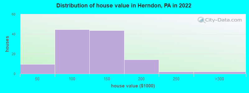
Estimated median house or condo value in 2023: $115,422 (it was $60,600 in 2000)
| Herndon: | $115,422 |
| PA: | $259,900 |
Mean prices in 2023: all housing units: $194,939; detached houses: $223,016; townhouses or other attached units: $73,293; in 2-unit structures: $82,779; mobile homes: $86,024
Median gross rent in 2023: $658.
Detailed information about poverty and poor residents in Herndon, PA
Compare current foreclosures near Herndon, PA:
| Photo | Address | Area | Beds / Baths | Price | Details |
|---|---|---|---|---|---|

|
#1
Urban Rd
Herndon, PA 17830
|
- sq. feet
|
- baths - beds |
show details | |

|
#2
Raupstal Rd
Herndon, PA 17830
|
- sq. feet
|
- baths - beds |
show details | |

|
#3
River Rd
Dalmatia, PA 17017
|
- sq. feet
|
1 baths 3 beds |
$14,900
|
show details |

|
#4
East New Market St
Freeburg, PA 17827
|
1,547 sq. feet
|
1 baths 3 beds |
show details | |

|
#5
N 2nd St
Lykens, PA 17048
|
829 sq. feet
|
1 baths 3 beds |
show details | |

|
#6
N Old Trl
Selinsgrove, PA 17870
|
1,584 sq. feet
|
2 baths 3 beds |
show details | |

|
#7
W Market St
Williamstown, PA 17098
|
1,318 sq. feet
|
1 baths 3 beds |
show details | |

|
#8
S 10th St
Sunbury, PA 17801
|
1,456 sq. feet
|
1 baths 3 beds |
show details | |

|
#9
E Spruce St
Williamstown, PA 17098
|
1,528 sq. feet
|
1 baths 3 beds |
show details | |

|
#10
E Church St
Freeburg, PA 17827
|
2,223 sq. feet
|
2 baths 4 beds |
show details |
| Photo | Address | Area | Beds / Baths | Price | Details |
|---|---|---|---|---|---|

|
#11
E Cameron St
Shamokin, PA 17872
|
1,072 sq. feet
|
1 baths 3 beds |
show details | |

|
#12
Carsonville Rd
Halifax, PA 17032
|
1,632 sq. feet
|
2 baths 4 beds |
show details | |

|
#13
Upper Rd
Shamokin, PA 17872
|
2,128 sq. feet
|
2 baths 3 beds |
show details | |

|
#14
Schoch St
Middleburg, PA 17842
|
1,200 sq. feet
|
1 baths 2 beds |
show details | |

|
#15
E Market St
Williamstown, PA 17098
|
1,080 sq. feet
|
1 baths 2 beds |
show details | |

|
#16
Rutter Rd
Halifax, PA 17032
|
1,066 sq. feet
|
1 baths 3 beds |
show details | |

|
#17
Dunkel School Rd
Halifax, PA 17032
|
1,494 sq. feet
|
1 baths 2 beds |
show details | |

|
#18
Armstrong Valley Rd
Halifax, PA 17032
|
1,092 sq. feet
|
1 baths 3 beds |
show details | |

|
#19
Small Valley Rd
Halifax, PA 17032
|
1,960 sq. feet
|
1 baths 3 beds |
show details | |

|
#20
Enders Rd
Halifax, PA 17032
|
1,344 sq. feet
|
1 baths 4 beds |
show details |
| Photo | Address | Area | Beds / Baths | Price | Details |
|---|---|---|---|---|---|

|
#21
S Market St
Shamokin, PA 17872
|
- sq. feet
|
2 baths 3 beds |
show details | |

|
#22
North St
Millersburg, PA 17061
|
1,770 sq. feet
|
1 baths 3 beds |
show details | |

|
#23
State Route 209
Lykens, PA 17048
|
1,624 sq. feet
|
2 baths 3 beds |
show details | |

|
#24
Main St
Lykens, PA 17048
|
1,348 sq. feet
|
1 baths 2 beds |
show details | |

|
#25
Carsonville Rd
Halifax, PA 17032
|
1,632 sq. feet
|
1 baths 3 beds |
show details | |

|
#26
Midland Dr
Millersburg, PA 17061
|
1,040 sq. feet
|
2 baths 2 beds |
show details | |

|
#27
Spruce St
Lykens, PA 17048
|
1,485 sq. feet
|
2 baths 4 beds |
show details | |

|
#28
N 2nd St
Lykens, PA 17048
|
1,288 sq. feet
|
1 baths 3 beds |
show details | |

|
#29
Main St
Lykens, PA 17048
|
1,838 sq. feet
|
1 baths 3 beds |
show details | |

|
#30
W Center Lane
Valley View, PA 17983
|
- sq. feet
|
- baths - beds |
$1
|
show details |
| Photo | Address | Area | Beds / Baths | Price | Details |
|---|---|---|---|---|---|

|
#31
Market St
Halifax, PA 17032
|
2,522 sq. feet
|
1 baths 3 beds |
show details | |

|
#32
Lost Creek Dr
Selinsgrove, PA 17870
|
- sq. feet
|
2 baths 3 beds |
show details | |

|
#33
Route 209
Elizabethville, PA 17023
|
1,066 sq. feet
|
1 baths 3 beds |
show details | |

|
#34
N Market St
Elizabethville, PA 17023
|
1,200 sq. feet
|
1 baths 3 beds |
show details | |

|
#35
Laurel Hill Rd
Mount Pleasant Mills, PA 17853
|
- sq. feet
|
1 baths 3 beds |
show details | |

|
#36
W Pine St
Coal Township, PA 17866
|
- sq. feet
|
- baths - beds |
show details | |

|
#37
North St
Millersburg, PA 17061
|
- sq. feet
|
- baths - beds |
show details | |

|
#38
Valley View Rd
Millerstown, PA 17062
|
1,120 sq. feet
|
- baths - beds |
show details | |

|
#39
Burnside Dr
Coal Township, PA 17866
|
- sq. feet
|
- baths - beds |
show details | |

|
#40
S Pearl St
Shamokin, PA 17872
|
- sq. feet
|
- baths - beds |
show details |
| Photo | Address | Area | Beds / Baths | Price | Details |
|---|---|---|---|---|---|

|
#41
Park Rd
Valley View, PA 17983
|
- sq. feet
|
- baths - beds |
show details | |

|
#42
E Chestnut St
Shamokin, PA 17872
|
- sq. feet
|
- baths - beds |
show details | |

|
#43
S Market St
Millersburg, PA 17061
|
- sq. feet
|
- baths - beds |
show details | |

|
#44
E Vickie Ln
Elizabethville, PA 17023
|
- sq. feet
|
- baths - beds |
show details | |

|
#45
Susquehanna Rd
Northumberland, PA 17857
|
- sq. feet
|
- baths - beds |
show details | |

|
#46
Ridgewood Dr Apt 12
Millersburg, PA 17061
|
- sq. feet
|
- baths - beds |
show details | |

|
#47
Specktown Rd
Lykens, PA 17048
|
- sq. feet
|
- baths - beds |
show details | |

|
#48
Bucks Valley Rd
Newport, PA 17074
|
- sq. feet
|
- baths - beds |
show details | |

|
#49
S 3rd St
Shamokin, PA 17872
|
- sq. feet
|
- baths - beds |
show details | |

|
Check over 1 million property listings on Foreclosure.com!
|
browse all offers | |||


- 28193.7%White alone
- 113.7%Two or more races
- 62.0%Hispanic
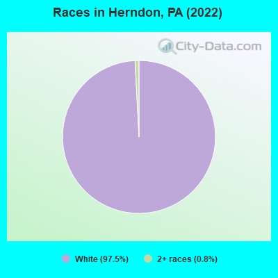
Races in Herndon detailed stats: ancestries, foreign born residents, place of birth
According to our research of Pennsylvania and other state lists, there were 4 registered sex offenders living in Herndon, Pennsylvania as of May 09, 2025.
The ratio of all residents to sex offenders in Herndon is 95 to 1.
 Recent articles from our blog. Our writers, many of them Ph.D. graduates or candidates, create easy-to-read articles on a wide variety of topics.

 | Moving from MD to Pittsbrugh?!?! (67 replies) |
| Charming Small Towns in PA within 3 Hours of Herndon, VA? (7 replies) |
| Bye Bye Heinz (92 replies) |
| Where Pittsburgh could fit 100,000 more people... (113 replies) |
| What Eyesores Near Downtown Hurt Pittsburgh's Looks The Worst? (147 replies) |
| living in the South Side Slopes? (35 replies) |
Latest news from Herndon, PA collected exclusively by city-data.com from local newspapers, TV, and radio stations
Ancestries: German (55.9%), American (10.6%), English (10.6%), Irish (5.6%), Pennsylvania German (2.8%), Danish (1.7%).
Current Local Time: EST time zone
Incorporated on 08/29/1902
Elevation: 460 feet
Land area: 0.80 square miles.
Population density: 433 people per square mile (low).

6 residents are foreign born
| This borough: | 1.6% |
| Pennsylvania: | 4.1% |
Median real estate property taxes paid for housing units with mortgages in 2023: $1,278 (1.3%)
Median real estate property taxes paid for housing units with no mortgage in 2023: $1,541 (1.1%)
Nearest city with pop. 50,000+: Lancaster, PA (54.0 miles
, pop. 56,348).
Nearest city with pop. 200,000+: Baltimore, MD (97.3 miles
, pop. 651,154).
Nearest city with pop. 1,000,000+: Philadelphia, PA (102.0 miles
, pop. 1,517,550).
Nearest cities:
Latitude: 40.70 N, Longitude: 76.84 W
Area code commonly used in this area: 570
| Here: | 3.7% |
| Pennsylvania: | 3.3% |

- Health care & social assistance (25.0%)
- Manufacturing (24.4%)
- Retail trade (8.8%)
- Construction (7.4%)
- Agriculture, forestry, fishing & hunting (4.7%)
- Administrative & support & waste management services (4.7%)
- Public administration (3.4%)

- Manufacturing (32.6%)
- Construction (13.3%)
- Health care & social assistance (13.3%)
- Agriculture, forestry, fishing & hunting (8.5%)
- Administrative & support & waste management services (7.3%)
- Public administration (4.8%)
- Retail trade (3.6%)

- Health care & social assistance (40.0%)
- Retail trade (15.4%)
- Manufacturing (13.8%)
- Finance & insurance (6.2%)
- Transportation & warehousing (4.6%)
- Administrative & support & waste management services (1.5%)
- Accommodation & food services (1.5%)
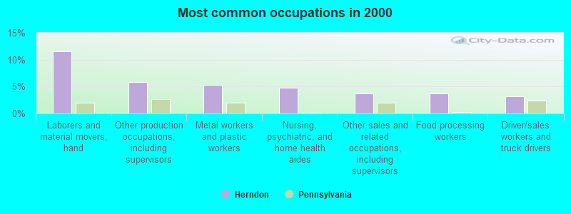
- Laborers and material movers, hand (11.6%)
- Other production occupations, including supervisors (5.8%)
- Metal workers and plastic workers (5.3%)
- Nursing, psychiatric, and home health aides (4.7%)
- Other sales and related occupations, including supervisors (3.7%)
- Food processing workers (3.7%)
- Driver/sales workers and truck drivers (3.2%)

- Laborers and material movers, hand (12.4%)
- Metal workers and plastic workers (8.8%)
- Food processing workers (6.2%)
- Other production occupations, including supervisors (6.2%)
- Life, physical, and social science technicians (5.3%)
- Driver/sales workers and truck drivers (5.3%)
- Material recording, scheduling, dispatching, and distributing workers (4.4%)
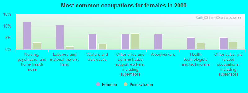
- Nursing, psychiatric, and home health aides (11.7%)
- Laborers and material movers, hand (10.4%)
- Waiters and waitresses (6.5%)
- Other office and administrative support workers, including supervisors (6.5%)
- Woodworkers (6.5%)
- Health technologists and technicians (5.2%)
- Other sales and related occupations, including supervisors (5.2%)
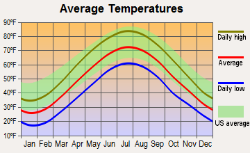
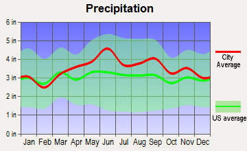
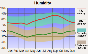
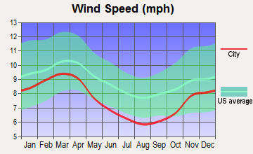
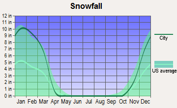
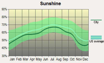
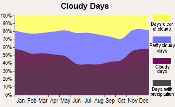
Average climate in Herndon, Pennsylvania
Based on data reported by over 4,000 weather stations
(lower is better)
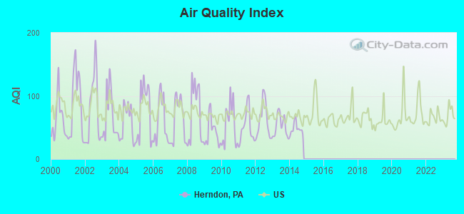
Air Quality Index (AQI) level in 2014 was 47.9. This is significantly better than average.
| City: | 47.9 |
| U.S.: | 72.6 |
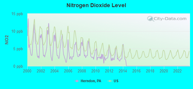
Nitrogen Dioxide (NO2) [ppb] level in 2013 was 2.78. This is significantly better than average. Closest monitor was 24.1 miles away from the city center.
| City: | 2.78 |
| U.S.: | 5.11 |
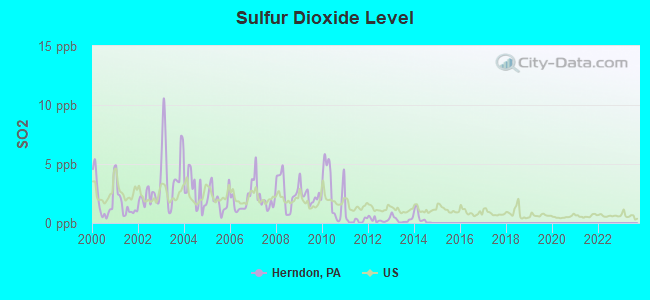
Sulfur Dioxide (SO2) [ppb] level in 2014 was 0.468. This is significantly better than average. Closest monitor was 24.1 miles away from the city center.
| City: | 0.468 |
| U.S.: | 1.515 |
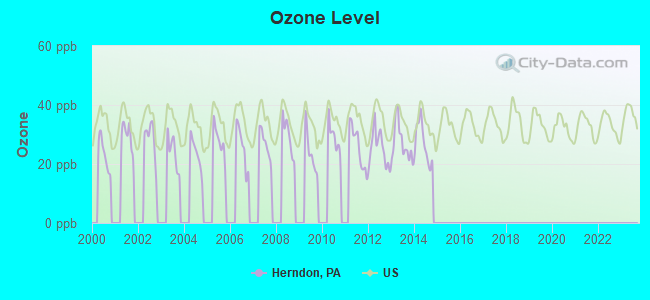
Ozone [ppb] level in 2014 was 27.1. This is better than average. Closest monitor was 24.1 miles away from the city center.
| City: | 27.1 |
| U.S.: | 33.3 |
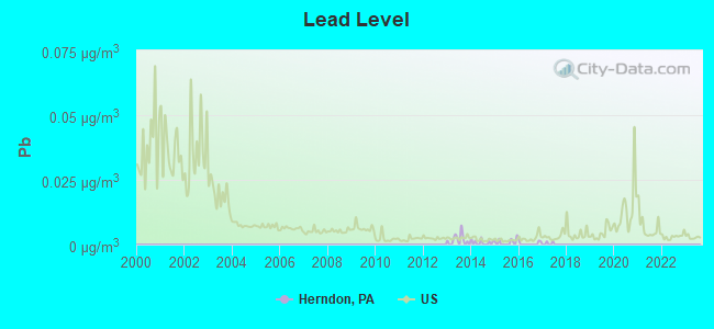
Lead (Pb) [µg/m3] level in 2016 was 0.00035. This is significantly better than average. Closest monitor was 17.5 miles away from the city center.
| City: | 0.00035 |
| U.S.: | 0.00931 |
Tornado activity:
Herndon-area historical tornado activity is near Pennsylvania state average. It is 14% smaller than the overall U.S. average.
On 5/31/1985, a category F4 (max. wind speeds 207-260 mph) tornado 43.5 miles away from the Herndon borough center caused between $5,000,000 and $50,000,000 in damages.
On 5/31/1985, a category F3 (max. wind speeds 158-206 mph) tornado 28.8 miles away from the borough center killed 6 people and injured 60 people and caused between $5,000,000 and $50,000,000 in damages.
Earthquake activity:
Herndon-area historical earthquake activity is significantly above Pennsylvania state average. It is 63% smaller than the overall U.S. average.On 8/23/2011 at 17:51:04, a magnitude 5.8 (5.8 MW, Depth: 3.7 mi, Class: Moderate, Intensity: VI - VII) earthquake occurred 201.9 miles away from Herndon center
On 1/16/1994 at 01:49:16, a magnitude 4.6 (4.6 MB, 4.6 LG, Depth: 3.1 mi, Class: Light, Intensity: IV - V) earthquake occurred 49.7 miles away from Herndon center
On 9/25/1998 at 19:52:52, a magnitude 5.2 (4.8 MB, 4.3 MS, 5.2 LG, 4.5 MW, Depth: 3.1 mi) earthquake occurred 193.0 miles away from the city center
On 10/7/1983 at 10:18:46, a magnitude 5.3 (5.1 MB, 5.3 LG, 5.1 ML) earthquake occurred 258.5 miles away from the city center
On 1/16/1994 at 00:42:43, a magnitude 4.2 (4.2 MB, 4.0 LG, Depth: 3.1 mi) earthquake occurred 51.1 miles away from Herndon center
On 1/31/1986 at 16:46:43, a magnitude 5.0 (5.0 MB) earthquake occurred 233.2 miles away from the city center
Magnitude types: regional Lg-wave magnitude (LG), body-wave magnitude (MB), local magnitude (ML), surface-wave magnitude (MS), moment magnitude (MW)
Natural disasters:
The number of natural disasters in Northumberland County (18) is near the US average (19).Major Disasters (Presidential) Declared: 13
Emergencies Declared: 4
Causes of natural disasters: Storms: 5, Floods: 4, Tropical Storms: 3, Hurricanes: 2, Tropical Depressions: 2, Winter Storms: 2, Blizzard: 1, Flash Flood: 1, Heavy Rain: 1, Mudslide: 1, Snowfall: 1, Snowstorm: 1, Tornado: 1, Wind: 1, Other: 2 (Note: some incidents may be assigned to more than one category).
Hospitals and medical centers near Herndon:
- LOVING CARE NURSING CENTER INC (Nursing Home, about 7 miles away; SELINSGROVE, PA)
- BAYADA HOME HEALTH CARE INC (Home Health Center, about 7 miles away; SELINSGROVE, PA)
- DAVITA - SELINSGROVE DIALYSIS (Dialysis Facility, about 8 miles away; SELINSGROVE, PA)
- KEPLER HOME, INC, THE (Nursing Home, about 11 miles away; ELIZABETHVILLE, PA)
- GOLDEN LIVINGCENTER-MANSION (Nursing Home, about 12 miles away; SUNBURY, PA)
- MANSION NURSING CONV HOME (Nursing Home, about 12 miles away; SUNBURY, PA)
- SUNBURY COMMUNITY HOSPITAL Acute Care Hospitals (about 12 miles away; SUNBURY, PA)
Colleges/universities with over 2000 students nearest to Herndon:
- Susquehanna University (about 7 miles; Selinsgrove, PA; Full-time enrollment: 2,495)
- Bucknell University (about 18 miles; Lewisburg, PA; FT enrollment: 3,418)
- Harrisburg Area Community College-Harrisburg (about 29 miles; Harrisburg, PA; FT enrollment: 13,276)
- Bloomsburg University of Pennsylvania (about 30 miles; Bloomsburg, PA; FT enrollment: 9,452)
- McCann School of Business & Technology (about 32 miles; Pottsville, PA; FT enrollment: 3,412)
- Pennsylvania State University-Penn State Harrisburg (about 35 miles; Middletown, PA; FT enrollment: 3,797)
- Pennsylvania College of Technology (about 39 miles; Williamsport, PA; FT enrollment: 5,291)
Public high school in Herndon:
- LINE MOUNTAIN HS (Students: 611, Location: 187 LINE MOUNTAIN ROAD, Grades: 9-12)
Public elementary/middle school in Herndon:
Points of interest:
Notable location: Herndon Fire Company 1 Station 63 (A). Display/hide its location on the map
Churches in Herndon include: Seibert Church (A), Zion Church (B). Display/hide their locations on the map
Drinking water stations with addresses in Herndon and their reported violations in the past:
DEER LODGE MOBILE HOME PARK (Serves MD, Population served: 96, Groundwater):Past health violations:WHITE OAK TAVERN (Population served: 50, Groundwater):Past monitoring violations:
- MCL, Monthly (TCR) - In AUG-2006, Contaminant: Coliform. Follow-up actions: St Public Notif requested (AUG-30-2006), St Violation/Reminder Notice (AUG-30-2006), St Public Notif received (SEP-04-2006), St Compliance achieved (NOV-10-2006)
- One routine major monitoring violation
- One minor monitoring violation
Past monitoring violations:FAMILY PRACTICE CENTER (Population served: 50, Groundwater):
- 2 routine major monitoring violations
Past health violations:PENNS TAVERN (Population served: 25, Groundwater):Past monitoring violations:
- MCL, Monthly (TCR) - Between OCT-2011 and DEC-2011, Contaminant: Coliform. Follow-up actions: St Public Notif requested (DEC-01-2011), St Public Notif received (DEC-01-2011), St Compliance achieved (DEC-01-2011), St Violation/Reminder Notice (DEC-01-2011)
- Monitoring, Source Water (GWR) - Between OCT-10-2011 and NOV-10-2011, Contaminant: E. COLI. Follow-up actions: St Violation/Reminder Notice (JAN-09-2012), St Compliance achieved (JAN-09-2012)
- One routine major monitoring violation
Past monitoring violations:
- One routine major monitoring violation
- 2 regular monitoring violations
| This borough: | 2.4 people |
| Pennsylvania: | 2.5 people |
| This borough: | 62.5% |
| Whole state: | 65.0% |
| This borough: | 7.4% |
| Whole state: | 6.6% |
Likely homosexual households (counted as self-reported same-sex unmarried-partner households)
- Lesbian couples: 0.7% of all households
- Gay men: 0.7% of all households
Banks with branches in Herndon (2011 data):
- The Gratz National Bank: Herdon Office Branch at 4231 State Route 147, branch established on 2008/06/01; Herndon Branch at Main Street, branch established on 1934/02/01. Info updated 2011/09/29: Bank assets: $175.2 mil, Deposits: $147.6 mil, headquarters in Gratz, PA, positive income, 4 total offices, Holding Company: Gnb Financial Services, Inc.
For population 15 years and over in Herndon:
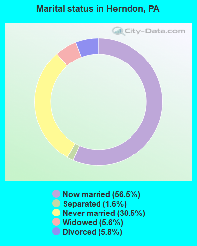
- Never married: 29.5%
- Now married: 52.7%
- Separated: 3.4%
- Widowed: 4.9%
- Divorced: 9.4%
For population 25 years and over in Herndon:
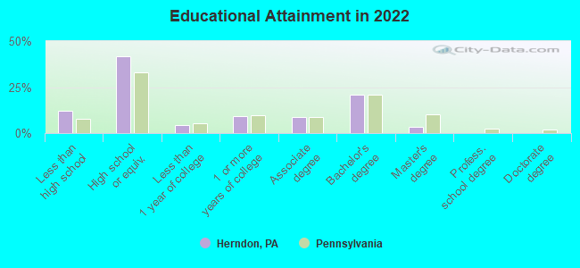
- High school or higher: 85.0%
- Bachelor's degree or higher: 20.6%
- Graduate or professional degree: 1.7%
- Unemployed: 1.0%
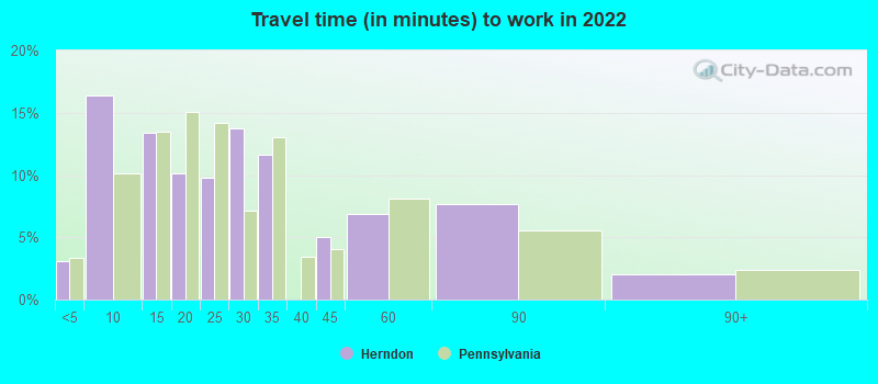
- Mean travel time to work (commute): 28.5 minutes
| Here: | 9.9 |
| Pennsylvania average: | 11.5 |
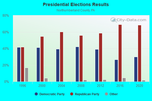
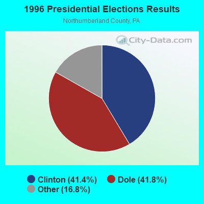
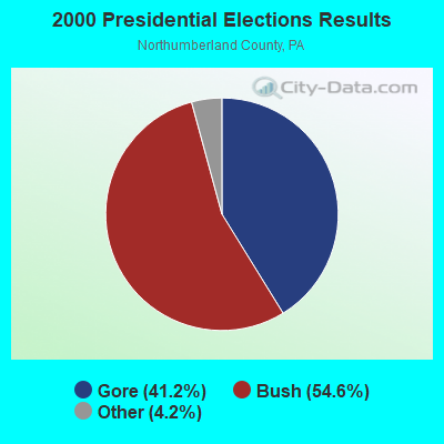
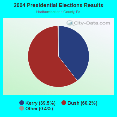
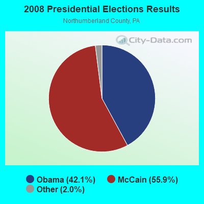
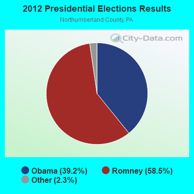


Graphs represent county-level data. Detailed 2008 Election Results
Religion statistics for Herndon, PA (based on Northumberland County data)
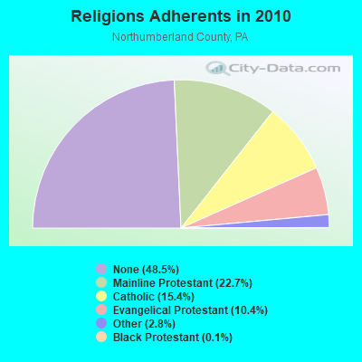
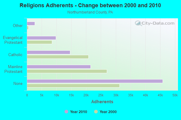
| Religion | Adherents | Congregations |
|---|---|---|
| Mainline Protestant | 21,455 | 102 |
| Catholic | 14,540 | 12 |
| Evangelical Protestant | 9,794 | 62 |
| Other | 2,662 | 9 |
| Black Protestant | 118 | 1 |
| Orthodox | 76 | 1 |
| None | 45,883 | - |
Food Environment Statistics:
| Northumberland County: | 2.09 / 10,000 pop. |
| Pennsylvania: | 2.04 / 10,000 pop. |
| Northumberland County: | 0.11 / 10,000 pop. |
| State: | 0.09 / 10,000 pop. |
| Northumberland County: | 0.66 / 10,000 pop. |
| State: | 0.88 / 10,000 pop. |
| Northumberland County: | 3.74 / 10,000 pop. |
| Pennsylvania: | 2.52 / 10,000 pop. |
| Northumberland County: | 6.92 / 10,000 pop. |
| Pennsylvania: | 7.12 / 10,000 pop. |
| Northumberland County: | 9.6% |
| Pennsylvania: | 9.1% |
| Northumberland County: | 29.3% |
| Pennsylvania: | 27.2% |
| Northumberland County: | 11.5% |
| State: | 11.5% |
Health and Nutrition:
| This city: | 44.7% |
| State: | 50.2% |
| Herndon: | 34.8% |
| State: | 47.1% |
| Herndon: | 27.7 |
| Pennsylvania: | 28.7 |
| This city: | 16.6% |
| Pennsylvania: | 20.8% |
| This city: | 6.6% |
| Pennsylvania: | 10.9% |
| Herndon: | 6.7 |
| Pennsylvania: | 6.8 |
| This city: | 28.2% |
| Pennsylvania: | 34.3% |
| Here: | 50.3% |
| Pennsylvania: | 56.2% |
| Herndon: | 72.1% |
| Pennsylvania: | 78.3% |
More about Health and Nutrition of Herndon, PA Residents
| Local government employment and payroll (March 2022) | |||||
| Function | Full-time employees | Monthly full-time payroll | Average yearly full-time wage | Part-time employees | Monthly part-time payroll |
|---|---|---|---|---|---|
| Financial Administration | 0 | $0 | 1 | $295 | |
| Totals for Government | 0 | $0 | 1 | $295 | |
Herndon government finances - Expenditure in 2022 (per resident):
- Current Operations - Regular Highways: $56,000 ($161.38)
Central Staff Services: $32,000 ($92.22)
General - Other: $19,000 ($54.76)
Local Fire Protection: $2,000 ($5.76)
Parks and Recreation: $1,000 ($2.88)
Herndon government finances - Revenue in 2022 (per resident):
- Charges - Other: $11,000 ($31.70)
- Federal Intergovernmental - Other: $5,000 ($14.41)
- Miscellaneous - Interest Earnings: $20,000 ($57.64)
Donations From Private Sources: $3,000 ($8.65)
Fines and Forfeits: $3,000 ($8.65)
- State Intergovernmental - Other: $24,000 ($69.16)
- Tax - Individual Income: $39,000 ($112.39)
Property: $36,000 ($103.75)
Occupation and Business License - Other: $2,000 ($5.76)
Public Utility License: $1,000 ($2.88)
Businesses in Herndon, PA
- Ace Hardware: 1
Strongest AM radio stations in Herndon:
- WKOK (1070 AM; 10 kW; SUNBURY, PA; Owner: SUNBURY BROADCASTING CORPORATION)
- WYGL (1240 AM; 1 kW; SELINSGROVE, PA; Owner: SUNAIR COMMUNICATIONS, INC.)
- WHP (580 AM; 5 kW; HARRISBURG, PA; Owner: CLEAR CHANNEL BROADCASTING LICENSES, INC.)
- WWJZ (640 AM; 50 kW; MOUNT HOLLY, NJ; Owner: ABC, INC.)
- WEEU (830 AM; 20 kW; READING, PA; Owner: WEEU BROADCASTING COMPANY)
- WCBM (680 AM; 50 kW; BALTIMORE, MD; Owner: WCBM MARYLAND, INC.)
- WVCH (740 AM; 50 kW; CHESTER, PA; Owner: WVCH COMMUNICATIONS, INC.)
- WRKK (1200 AM; 10 kW; HUGHESVILLE, PA; Owner: CLEAR CHANNEL BROADCASTING LICENSES, INC.)
- WZZD (990 AM; 50 kW; PHILADELPHIA, PA; Owner: PENNSYLVANIA MEDIA ASSOCIATES, INC.)
- WPEN (950 AM; 50 kW; PHILADELPHIA, PA; Owner: GREATER PHILADELPHIA RADIO, INC.)
- WBAL (1090 AM; 50 kW; BALTIMORE, MD; Owner: HEARST RADIO, INC.)
- KYW (1060 AM; 50 kW; PHILADELPHIA, PA; Owner: INFINITY BROADCASTING OPERATIONS, INC.)
- WIEZ (670 AM; daytime; 5 kW; LEWISTOWN, PA; Owner: FIRST MEDIA RADIO, LLC)
Strongest FM radio stations in Herndon:
- WQKX (94.1 FM; SUNBURY, PA; Owner: SUNBURY BROADCASTING CORPORATION)
- WEGH (107.3 FM; NORTHUMBERLAND, PA; Owner: SUNBURY BROADCASTING CORPORATION)
- WYGL-FM (100.5 FM; ELIZABETHVILLE, PA; Owner: SUNAIR COMMUNICATIONS, INC.)
- WLZS (106.1 FM; BEAVER SPRINGS, PA; Owner: STARVIEW MEDIA, INC)
- WITF-FM (89.5 FM; HARRISBURG, PA; Owner: WITF, INC.)
- WLGL (92.3 FM; RIVERSIDE, PA; Owner: SUNAIR COMMUNICATIONS, INC.)
- WQLV (98.9 FM; MILLERSBURG, PA; Owner: HEPCO COMMUNICATIONS, INC.)
- WVLY-FM (100.9 FM; MILTON, PA; Owner: MILTON-LEWISBURG BROADCASTING, INC.)
- WQSU (88.9 FM; SELINSGROVE, PA; Owner: SUSQUEHANNA UNIVERSITY)
- WWBE (98.3 FM; MIFFLINBURG, PA; Owner: B-98 BROADCASTING, INC)
- WFYY (106.5 FM; BLOOMSBURG, PA; Owner: RADIO FRIENDZ, INC.)
- WJUN-FM (92.5 FM; MEXICO, PA; Owner: STARVIEW MEDIA, INC.)
- WBLJ-FM (95.3 FM; SHAMOKIN, PA; Owner: CLEAR CHANNEL BROADCASTING LICENSES, INC.)
- WRVV (97.3 FM; HARRISBURG, PA; Owner: CLEAR CHANNEL BROADCASTING LICENSES, INC.)
- WCXR (103.7 FM; LEWISBURG, PA; Owner: SOUTH WILLIAMSPORT SABRECOM, INC.)
- W299AF (107.7 FM; CATAWISSA, PA; Owner: SALT & LIGHT MEDIA MINISTRIES, INC.)
- WRVH (107.9 FM; WILLIAMSPORT, PA; Owner: SOUTH WILLIAMSPORT SABRECOM, INC.)
- WBGM (88.1 FM; NEW BERLIN, PA; Owner: MONTROSE BROADCASTING CORP.)
- WQJU (107.1 FM; MIFFLINTOWN, PA; Owner: CENTRAL PA CHRISTIAN INSTITUTE, INC.)
- WJRC (90.9 FM; LEWISTOWN, PA; Owner: SALT AND LIGHT MEDIA MINISTRIES, INC)
TV broadcast stations around Herndon:
- WITF-TV (Channel 33; HARRISBURG, PA; Owner: WITF, INC.)
- WLYH-TV (Channel 15; LANCASTER, PA; Owner: TELEVISION STATION GROUP LICENSE SUBSIDIARY, LLC)
- WHTM-TV (Channel 27; HARRISBURG, PA; Owner: HARRISBURG TELEVISION, INC.)
- WHP-TV (Channel 21; HARRISBURG, PA; Owner: CLEAR CHANNEL BROADCASTING LICENSES, INC.)
- W18BC (Channel 18; MIDDLEBURG, PA; Owner: HEIRLOOM MINISTRIES, INC.)
Herndon fatal accident list:
Dec 20, 2004 02:35 AM, Sr-147, Lat: 40.699996, Lon: -76.849844, Vehicles: 2, Persons: 2, Fatalities: 1
Nov 14, 2000 00:10 AM, Sr-147, Lat: 40.699996, Lon: -76.849844, Vehicles: 1, Persons: 1, Fatalities: 1, Drunk persons involved: 1
Jan 1, 1996 06:45 PM, 147, Vehicles: 2, Persons: 3, Fatalities: 1, Drunk persons involved: 1
Nov 4, 1987 10:15 AM, Sr01470280, Vehicles: 2, Persons: 2, Fatalities: 1
FCC Registered Antenna Towers:
18 (See the full list of FCC Registered Antenna Towers in Herndon)FCC Registered Private Land Mobile Towers:
1- 4 Mi Se Of Selinsgrove (Lat: 40.743139 Lon: -76.833583), Structure height: 91 m, Call Sign: WPBN252,
Assigned Frequencies: 462.750 MHz, 462.750 MHz, Grant Date: 05/22/2018, Expiration Date: 06/17/2028, Registrant: Green\'s Communications, Inc., 210 West Market Street, Pottsville, PA 17901, Phone: (570) 628-5556, Fax: (570) 622-6666, Email:
FCC Registered Broadcast Land Mobile Towers:
2- Lat: 40.667500 Lon: -76.827222, Call Sign: WQSW630,
Assigned Frequencies: 457.862 MHz, 452.812 MHz, 451.512 MHz, 452.412 MHz, 452.137 MHz, 451.762 MHz, Grant Date: 11/22/2023, Expiration Date: 11/27/2033, Certifier: Keith A Harro, Registrant: Washington Radio Reports, Gettysburg, PA 17325, Phone: (717) 334-0668, Fax: (717) 334-6440, Email:
- Lat: 40.718167 Lon: -76.839639, Call Sign: WRXB641,
Assigned Frequencies: 452.512 MHz, 452.687 MHz, 452.787 MHz, 452.037 MHz, 452.712 MHz, Grant Date: 04/22/2023, Expiration Date: 04/22/2033, Certifier: Melvin Kauffman, Registrant: Washington Radio Reports, Gettysburg, PA 17325, Phone: (717) 334-0668, Fax: (717) 334-6440, Email:
FCC Registered Microwave Towers:
5- On Little Mountain 2.5 Mi Nne Of (Lat: 40.743139 Lon: -76.833556), Overall height: 25 m, Call Sign: WNTY672,
Assigned Frequencies: 6590.62 MHz, Grant Date: 05/20/2010, Expiration Date: 04/11/2020, Cancellation Date: 06/13/2020, Registrant: Mission Critical Partners, Inc., 690 Gray\'s Woods Blvd, Port Matilda, PA 16870, Phone: (888) 862-7911, Email:
- PL44HO187, Rd2, Lubold Road (Lat: 40.705389 Lon: -76.833417), Type: Ltower, Structure height: 76.2 m, Overall height: 79.2 m, Call Sign: WQYB885,
Assigned Frequencies: 10935.0 MHz, 10935.0 MHz, 10935.0 MHz, 10935.0 MHz, 10935.0 MHz, 10935.0 MHz, 10935.0 MHz, 10935.0 MHz, 10935.0 MHz, Grant Date: 08/11/2016, Expiration Date: 08/11/2026, Cancellation Date: 03/05/2018, Certifier: Kyle B Entz, Registrant: Sprint Corporation, 12502 Sunrise Valley Drive, M/S: Varesa0209, Reston, VA 20196, Phone: (800) 572-8256, Fax: (703) 433-4483, Email:
- KLINGERSTOWN, Snowdale Road (Lat: 40.689611 Lon: -76.697083), Type: Ltower, Structure height: 76.2 m, Overall height: 78 m, Call Sign: WRAU495,
Assigned Frequencies: 10815.0 MHz, Grant Date: 03/06/2018, Expiration Date: 03/06/2028, Certifier: Dave Cundiff, Registrant: At&t Services, Inc., 208 S Akard St, 20f, Dallas, TX 75202, Phone: (855) 699-7073, Fax: (214) 746-6410, Email:
- PL44HO187, Rd2, Lubold Road (Lat: 40.705389 Lon: -76.833417), Type: Ltower, Structure height: 76.2 m, Overall height: 79.2 m, Call Sign: WRCB267,
Assigned Frequencies: 17865.0 MHz, 17915.0 MHz, 17865.0 MHz, 17915.0 MHz, 17865.0 MHz, 17915.0 MHz, 17865.0 MHz, 17915.0 MHz, 17865.0 MHz, 17915.0 MHz... (+10 more), Grant Date: 08/14/2018, Expiration Date: 08/14/2028, Cancellation Date: 06/21/2024, Certifier: David Werblow, Registrant: T-Mobile Usa, Inc., 12920 Se 38th Street, Bellevue, WA 98006, Phone: (425) 383-8401, Email:
- 2NO4470A, Rd2, Lubold Road (Lat: 40.705389 Lon: -76.833417), Type: Ltower, Structure height: 76.2 m, Overall height: 79.2 m, Call Sign: WSEM466,
Assigned Frequencies: 11585.0 MHz, 11585.0 MHz, 11585.0 MHz, 11585.0 MHz, 11585.0 MHz, 11585.0 MHz, 11585.0 MHz, 11585.0 MHz, 11585.0 MHz, 11585.0 MHz... (+14 more), Grant Date: 09/04/2024, Expiration Date: 09/04/2034, Certifier: Jenny Knopf, Registrant: T-Mobile Usa, Inc., 12920 Se 38th Street, Bellevue, WA 98006, Phone: (425) 383-8401, Fax: (425) 383-4040, Email:
FCC Registered Amateur Radio Licenses:
12 (See the full list of FCC Registered Amateur Radio Licenses in Herndon)FAA Registered Aircraft:
1- Aircraft: PIPER PA-28-180 (Category: Land, Seats: 4, Weight: Up to 12,499 Pounds, Speed: 107 mph), Engine: LYCOMING O&VO-360 SER (180 HP) (Reciprocating)
N-Number: 3683R, N3683R, N-3683R, Serial Number: 28-5785, Year manufactured: 1969, Airworthiness Date: 12/04/1969, Certificate Issue Date: 03/01/2017
Registrant (Individual): Kristopher L Strance, 236 4th St, Herndon, PA 17830
| Most common first names in Herndon, PA among deceased individuals | ||
| Name | Count | Lived (average) |
|---|---|---|
| Charles | 19 | 77.6 years |
| John | 17 | 76.6 years |
| Mary | 17 | 78.8 years |
| William | 15 | 76.1 years |
| Paul | 11 | 69.4 years |
| George | 10 | 77.0 years |
| Helen | 10 | 82.4 years |
| Carrie | 9 | 85.7 years |
| Harry | 9 | 72.5 years |
| Robert | 8 | 74.0 years |
| Most common last names in Herndon, PA among deceased individuals | ||
| Last name | Count | Lived (average) |
|---|---|---|
| Troutman | 16 | 75.4 years |
| Wolfe | 11 | 75.9 years |
| Shaffer | 11 | 77.5 years |
| Snyder | 10 | 66.7 years |
| Leitzel | 9 | 70.8 years |
| Hoffman | 9 | 76.9 years |
| Herb | 8 | 82.1 years |
| Bordner | 8 | 72.5 years |
| Long | 8 | 81.4 years |
| Straub | 8 | 70.1 years |
- 66.0%Fuel oil, kerosene, etc.
- 17.9%Electricity
- 8.5%Bottled, tank, or LP gas
- 5.7%Wood
- 1.9%Coal or coke
- 37.9%Electricity
- 24.1%Fuel oil, kerosene, etc.
- 20.7%Bottled, tank, or LP gas
- 6.9%Coal or coke
- 6.9%Other fuel
- 3.4%No fuel used
Herndon compared to Pennsylvania state average:
- Median house value significantly below state average.
- Unemployed percentage significantly below state average.
- Black race population percentage significantly below state average.
- Hispanic race population percentage significantly below state average.
- Foreign-born population percentage significantly below state average.
- Length of stay since moving in significantly above state average.
- House age above state average.
- Number of college students below state average.
Herndon on our top lists:
- #46 on the list of "Top 100 cities with oldest houses"
- #61 on the list of "Top 100 cities with old houses but young residents"
- #42 on the list of "Top 101 counties with the highest number of deaths per 1000 residents 2007-2013 (pop. 50,000+)"
- #51 on the list of "Top 101 counties with the lowest ground withdrawal of fresh water for public supply (pop. 50,000+)"
- #71 on the list of "Top 101 counties with the lowest percentage of residents relocating to other counties in 2011 (pop. 50,000+)"