File:New London Map 49%.png
Jump to navigation
Jump to search
No higher resolution available.
New_London_Map_49%.png (128 × 256 pixels, file size: 3 KB, MIME type: image/png)
Captions
Captions
Add a one-line explanation of what this file represents
| Description |
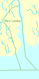
Of the 10.76 square miles of en:New London, Connecticut, 5.23 square miles (49%) is water. Derived from 2000 Census data and U.S. Census Bureau mapping utility. |
| Date | |
| Source | Own work |
| Author | User:RalphThayer on en.wikipedia |
Licensing
[edit]
| I, the copyright holder of this work, release this work into the public domain. This applies worldwide. In some countries this may not be legally possible; if so: I grant anyone the right to use this work for any purpose, without any conditions, unless such conditions are required by law. |
Original upload log
[edit]
The original description page was here. All following user names refer to en.wikipedia.
| Upload date | User | Bytes | Dimensions | Comment |
|---|---|---|---|---|
| 2006-12-30 05:54:17 | RalphThayer | 2714 | 128×256 | Derived from U.S. Census Bureau mapping utility. |
File history
Click on a date/time to view the file as it appeared at that time.
| Date/Time | Thumbnail | Dimensions | User | Comment | |
|---|---|---|---|---|---|
| current | 08:48, 28 November 2009 | | 128 × 256 (3 KB) | CommonsHelper2 Bot (talk | contribs) | {{BotMoveToCommons|en.wikipedia|year={{subst:CURRENTYEAR}}|month={{subst:CURRENTMONTHNAME}}|day={{subst:CURRENTDAY}}}} Of the 10.76 square miles of en:New London, Connecticut, 5.23 square miles (49%) is water. Derived from 2000 Census data and U.S |
You cannot overwrite this file.
File usage on Commons
There are no pages that use this file.
File usage on other wikis
The following other wikis use this file:
- Usage on en.wikipedia.org
- Usage on it.wikipedia.org
- Usage on uk.wikipedia.org