File:RegionsofAsia-Census.PNG
From Wikimedia Commons, the free media repository
Jump to navigation
Jump to search
RegionsofAsia-Census.PNG (497 × 430 pixels, file size: 28 KB, MIME type: image/png)
File information
Structured data
Captions
Captions
Add a one-line explanation of what this file represents
Summary
[edit]| DescriptionRegionsofAsia-Census.PNG |
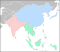
English: A flat map of Asia with country dividing lines Created in GIMP by Brian Davis Optimized Palette. Includes the Indian subcontinent in red. |
| Date | 21 August 2009 (original upload date) |
| Source | Transferred from en.wikipedia to Commons by IngerAlHaosului using CommonsHelper. |
| Author | Diego de Sequeira at English Wikipedia |
Licensing
[edit]| Public domainPublic domainfalsefalse |
| This work has been released into the public domain by its author, Diego de Sequeira at English Wikipedia. This applies worldwide. In some countries this may not be legally possible; if so: Diego de Sequeira grants anyone the right to use this work for any purpose, without any conditions, unless such conditions are required by law.Public domainPublic domainfalsefalse |
Original upload log
[edit]The original description page was here. All following user names refer to en.wikipedia.
- 2009-08-21 18:56 Elockid 497×430× (28470 bytes) Reverted to version as of 15:00, 1 January 2007 This is the correct definitions. Bangladesh is in South Asia
- 2009-08-21 17:21 KeigoH 497×430× (19763 bytes)
- 2009-08-21 17:20 KeigoH 497×430× (19756 bytes) Reverted to version as of 17:12, 21 August 2009
- 2009-08-21 17:14 KeigoH 497×430× (28470 bytes) Reverted to version as of 15:00, 1 January 2007
- 2009-08-21 17:12 KeigoH 497×430× (19756 bytes)
- 2007-01-01 15:00 Diego de Sequeira 497×430× (28470 bytes)
File history
Click on a date/time to view the file as it appeared at that time.
| Date/Time | Thumbnail | Dimensions | User | Comment | |
|---|---|---|---|---|---|
| current | 17:36, 21 April 2019 |  | 497 × 430 (28 KB) | A ba gazc (talk | contribs) | soutjeast asia |
| 19:48, 15 January 2010 |  | 497 × 430 (28 KB) | File Upload Bot (Magnus Manske) (talk | contribs) | {{BotMoveToCommons|en.wikipedia|year={{subst:CURRENTYEAR}}|month={{subst:CURRENTMONTHNAME}}|day={{subst:CURRENTDAY}}}} {{Information |Description={{en|A flat map of Asia with country dividing lines Created in GIMP by Brian Davis Optimized Palette. Includ |
You cannot overwrite this file.
File usage on Commons
There are no pages that use this file.
File usage on other wikis
The following other wikis use this file:
- Usage on ar.wikipedia.org
- شتات أرمني
- شتات عراقي
- شتات لبناني
- شتات سوري
- أمريكيون آسيويون
- شتات باكستاني
- إندونيسيون عبر البحار
- قالب:آسيويون عبر البحار
- آسيويون
- الشتات الأذربيجاني
- شتات تاميلي سريلانكي
- الشتات البنجابي
- الفلبينيون في الإمارات العربية المتحدة
- سارة بالاباجان سيرينو
- يابانيو المهجر
- شتات بنغلاديشي
- شتات هندي
- شتات سريلانكي
- شتات فلبيني
- الشتات الأفغاني
- شتات إماراتي
- مارابو
- أردنيون في أستراليا
- Usage on cs.wikipedia.org
- Usage on el.wikipedia.org
- Usage on en.wikipedia.org
- Asian people
- User:Cumi2got
- User:Wakanebe Wizard
- Template:User Asian
- User:Ariffuddin
- User:Arka.tukai
- User:Lejames18
- User:WASkier
- User:CharlesIsSMart
- User:TanahTumpuhnyaDarahku
- User:Roaringtigers17
- User:Sammyknowsitall
- User:Danipodolski
- User:Zochaian
- User:Abangjorg
- User:Kartunpedia
- User:Devansu rathod
- User:Flannel23
- User:GujaratiHistoryinDNA
- User:Hades699
- User:KratosVAsphodel
- User:Asang Lawai
- User:JamesBNE
- User:Zjin1
- User:ThatOneFilipinoExtremeist/Userboxes
View more global usage of this file.
Structured data
Items portrayed in this file
depicts
Hidden category: