Search results
Jump to navigation
Jump to search
Search categories • Skip PDFs and DjVus • View other tools
|
Help
|
|
Browse
|
Search
|
Create the page "San Andreas, California" on this wiki!
- org/licenses/by/3.0CC BY 3.0 Creative Commons Attribution 3.0 truetrue English Mormon Rocks at the San Andreas Fault, California, USA as viewed from a FPV drone....(WebM VP9 video file, 1 min 13 s) - 03:01, 25 November 2023
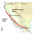
- holder of this work, hereby publish it under the following license: English Map illustrating the location of the San Andreas fault zone in California...(512 × 507 (57 KB)) - 11:13, 13 June 2024
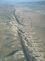
- English San Andreas Fault in the Carrizo Plain, Central California applies to jurisdiction: United States of America determination method or standard:...(300 × 439 (82 KB)) - 18:27, 17 August 2024
- English: San Andreas, California <nowiki>San Andreas; San Andreas; San Andreas; Сан-Андреас; San Andreas; Сан-Андреас; San Andreas; سن آندریاس; 聖安德烈亞斯; San Andreas;...21 members (1 subcategory, 20 files) - 10:44, 14 March 2021
- Bytes) {{Information| |Description = The San Andreas fault system and other large faults in California - different segments of the fault display different...(1,400 × 1,500 (41 KB)) - 02:44, 24 November 2022
- View of San Francisco, California, from Twin Peaks. Foto: Andreas Gronski 2001, GNU_FDL English determination method or standard: SHA-1...(500 × 375 (271 KB)) - 20:24, 17 October 2024
- illustrated fact sheet of marine terrices in California located in the administrative territorial entity: California publisher: United States Geological Survey...(1,275 × 1,650 (4.05 MB)) - 21:40, 17 August 2024
- https://creativecommons.org/publicdomain/mark/1.0/PDMCreative Commons Public Domain Mark 1.0falsefalse English San Andreas Fault 1906...(1,467 × 2,561 (1.8 MB)) - 17:13, 16 September 2022
- cutting granodiorite in core through the San Andreas fault, Mojave segment near Elizabeth Lake, California, USA. author name string: Rtwilliamsgeo Wikimedia...(4,032 × 3,024 (11.56 MB)) - 03:26, 2 June 2023
- English California Streets and Highways Code section determination method: SHA-1...(900 × 1,350 (75 KB)) - 06:15, 27 January 2024
- File:Elkhorn valley1.JPG (category Valleys of California)hills of the Diablo Range. The nearest town is Maricopa, California. Elkhorn Valley is only a few miles from the notorious San Andreas Fault. English...(2,560 × 1,920 (1.01 MB)) - 12:42, 27 September 2020
- English California Streets and Highways Code section determination method or standard: SHA-1...(900 × 1,350 (77 KB)) - 06:16, 27 January 2024
- English Captions for a map of Level IV ecoregions in California applies to jurisdiction: United States of America determination method: work of the federal...(5,400 × 7,050 (1.31 MB)) - 07:03, 20 August 2024
- Street a San Francisco in California (USA). object of statement has role: photographer author name string: Andrea Ripetta Wikimedia username: AndreaRipetta...(2,976 × 3,968 (3.36 MB)) - 10:56, 23 August 2024
- Transformní zlom v oblasti Kalifornie. http://en.wikipedia.org/wiki/Image:San_Andreas_Fault_-_Carrizo_Plains.jpg English applies to jurisdiction: United States...(250 × 338 (21 KB)) - 07:50, 20 August 2024
- org/publicdomain/mark/1.0/PDMCreative Commons Public Domain Mark 1.0falsefalse English San Andreas Valley 1867 applies to jurisdiction: United States of America determination...(3,808 × 2,856 (3.33 MB)) - 05:04, 7 October 2024
- File:BayareaUSGS.jpg (category California Coast Ranges)Satellite map of the San Francisco Bay Area of Northern California - from the U.S. Geological Survey. The effect of the San Andreas Fault on the terrain...(769 × 798 (613 KB)) - 06:48, 20 August 2024
- All following user names refer to en.wikipedia. English SMC seal highlights the Mountains, crystal springs, San Andreas lake, the bay, 101 and 280,...(382 × 382 (317 KB)) - 07:14, 5 November 2021
- Commons Public Domain Mark 1.0falsefalse English The San Felipe fault zone is within the San Andreas fault system. applies to jurisdiction: United States...(1,222 × 728 (1.55 MB)) - 18:32, 17 August 2024
- English The Big T, the yearbook of the California Institute of Technology...(1,291 × 1,795 (77.03 MB)) - 22:21, 14 May 2024


