Size of this preview: 457 × 599 pixels. Other resolutions: 183 × 240 pixels | 366 × 480 pixels | 724 × 949 pixels.
Original file (724 × 949 pixels, file size: 73 KB, MIME type: image/png)
File history
Click on a date/time to view the file as it appeared at that time.
| Date/Time | Thumbnail | Dimensions | User | Comment | |
|---|---|---|---|---|---|
| current | 14:17, 8 October 2013 |  | 724 × 949 (73 KB) | WikiEditor2004 | aesthetics |
| 10:20, 24 December 2009 |  | 717 × 944 (73 KB) | WikiEditor2004 | aesthetics | |
| 18:50, 1 June 2009 |  | 717 × 944 (73 KB) | WikiEditor2004 | ||
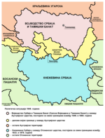
| 22:19, 13 February 2008 |  | 522 × 557 (28 KB) | Imbris~commonswiki | The image must be free of POV. The image I'am proposing is using different colours for the Principality of Serbia and Serb Voivodship and Tamiš Banate. | |
| 11:58, 1 May 2007 |  | 522 × 613 (70 KB) | Tene~commonswiki | Optimised (0) | |
| 21:40, 21 December 2006 |  | 522 × 613 (87 KB) | Electionworld | {{ew|en|PANONIAN}} Self-made map by PANONIAN {{PD-user|PANONIAN}} Category:Maps of Serbia |
File usage
The following 6 pages use this file:
Global file usage
The following other wikis use this file:
- Usage on ast.wikipedia.org
- Usage on ca.wikipedia.org
- Usage on cs.wikipedia.org
- Usage on el.wikipedia.org
- Usage on es.wikipedia.org
- Usage on et.wikipedia.org
- Usage on fr.wikipedia.org
- Usage on gl.wikipedia.org
- Usage on he.wikipedia.org
- Usage on ja.wikipedia.org
- Usage on ka.wikipedia.org
- Usage on lt.wikipedia.org
- Usage on nl.wikipedia.org
- Usage on sl.wikipedia.org
- Usage on sq.wikipedia.org
- Usage on sv.wikipedia.org
- Usage on th.wikipedia.org
- Usage on tr.wikipedia.org
- Usage on uk.wikipedia.org
- Usage on vi.wikipedia.org
- Usage on zh.wikipedia.org


