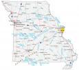
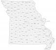
Missouri County Map and Independent City

About the map
This Missouri county map displays its 114 counties. Its tally of 114 is the fifth highest of counties in the United States. But St. Louis is actually an independent city in Missouri. Outside of Missouri, only Maryland, Nevada and Virginia also have independent cities. These government units sit outside the jurisdiction of any county.

The most populous county in Missouri is St. Louis County with close to 1 million residents. In fact, it has such a high population that it’s in the top 50 counties with the highest population. The least populated and smallest-sized county is Worth County with just over 2000 people and 266.8 square miles.
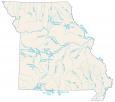
In terms of size, Texas County is the largest county and occupies an area of 1179.2 square miles. The Missouri River determines several county divisional boundaries in the center of the state. But interestingly, it’s the Mississippi River that outlines the entire eastern state boundary.

You are free to use our county map of Missouri for educational and commercial uses. Attribution is required. How to attribute?
Missouri county list
| FIPS Code | Name | Land (sq mi) | Water (sq mi) | Population (2024) |
|---|---|---|---|---|
| 29-001 | Adair County | 567.3 | 2.1 | 25,660 |
| 29-003 | Andrew County | 432.6 | 3.7 | 18,091 |
| 29-005 | Atchison County | 547.3 | 2.8 | 5,139 |
| 29-007 | Audrain County | 692.2 | 4.6 | 24,304 |
| 29-009 | Barry County | 778.3 | 12.7 | 35,618 |
| 29-011 | Barton County | 592.0 | 4.7 | 11,717 |
| 29-013 | Bates County | 836.7 | 14.7 | 16,394 |
| 29-015 | Benton County | 704.0 | 48.5 | 20,614 |
| 29-017 | Bollinger County | 617.9 | 3.3 | 10,610 |
| 29-019 | Boone County | 685.5 | 5.5 | 192,154 |
| 29-021 | Buchanan County | 408.2 | 6.9 | 83,574 |
| 29-023 | Butler County | 694.7 | 4.3 | 41,814 |
| 29-025 | Caldwell County | 426.4 | 3.2 | 9,000 |
| 29-027 | Callaway County | 834.6 | 12.8 | 45,126 |
| 29-029 | Camden County | 656.0 | 52.6 | 44,135 |
| 29-031 | Cape Girardeau County | 578.5 | 7.8 | 83,658 |
| 29-033 | Carroll County | 694.6 | 6.8 | 8,414 |
| 29-035 | Carter County | 507.4 | 1.7 | 5,359 |
| 29-037 | Cass County | 696.6 | 5.8 | 113,873 |
| 29-039 | Cedar County | 474.5 | 24.2 | 15,023 |
| 29-041 | Chariton County | 751.2 | 15.6 | 7,397 |
| 29-043 | Christian County | 562.6 | 1.2 | 96,045 |
| 29-045 | Clark County | 504.6 | 7.2 | 6,623 |
| 29-047 | Clay County | 397.7 | 11.0 | 263,370 |
| 29-049 | Clinton County | 419.0 | 4.5 | 21,721 |
| 29-051 | Cole County | 391.5 | 7.4 | 77,625 |
| 29-053 | Cooper County | 564.8 | 4.4 | 17,122 |
| 29-055 | Crawford County | 742.5 | 1.3 | 22,808 |
| 29-057 | Dade County | 490.0 | 16.2 | 7,622 |
| 29-059 | Dallas County | 540.9 | 1.9 | 17,877 |
| 29-061 | Daviess County | 563.3 | 5.8 | 8,541 |
| 29-063 | DeKalb County | 421.4 | 4.5 | 9,884 |
| 29-065 | Dent County | 752.8 | 1.7 | 14,721 |
| 29-067 | Douglas County | 813.6 | 1.0 | 12,290 |
| 29-069 | Dunklin County | 541.1 | 6.1 | 27,002 |
| 29-071 | Franklin County | 922.7 | 7.9 | 107,256 |
| 29-073 | Gasconade County | 519.0 | 7.0 | 14,655 |
| 29-075 | Gentry County | 491.4 | 0.3 | 6,298 |
| 29-077 | Greene County | 675.3 | 2.6 | 307,942 |
| 29-079 | Grundy County | 435.3 | 2.7 | 9,766 |
| 29-081 | Harrison County | 722.5 | 3.9 | 8,186 |
| 29-083 | Henry County | 696.9 | 35.4 | 22,575 |
| 29-085 | Hickory County | 398.8 | 12.9 | 8,766 |
| 29-087 | Holt County | 462.7 | 7.7 | 4,241 |
| 29-089 | Howard County | 463.8 | 7.7 | 10,150 |
| 29-091 | Howell County | 927.2 | 1.1 | 40,762 |
| 29-093 | Iron County | 550.3 | 1.8 | 9,420 |
| 29-095 | Jackson County | 604.5 | 11.8 | 727,362 |
| 29-097 | Jasper County | 638.5 | 2.8 | 126,479 |
| 29-099 | Jefferson County | 656.5 | 7.8 | 231,888 |
| 29-101 | Johnson County | 829.3 | 3.9 | 55,880 |
| 29-103 | Knox County | 504.0 | 2.8 | 3,740 |
| 29-105 | Laclede County | 764.7 | 3.3 | 36,738 |
| 29-107 | Lafayette County | 628.4 | 10.5 | 33,511 |
| 29-109 | Lawrence County | 611.7 | 1.6 | 39,151 |
| 29-111 | Lewis County | 505.0 | 5.8 | 9,852 |
| 29-113 | Lincoln County | 626.6 | 13.9 | 65,888 |
| 29-115 | Linn County | 615.6 | 5.8 | 11,910 |
| 29-117 | Livingston County | 532.3 | 6.3 | 14,658 |
| 29-119 | McDonald County | 539.5 | 0.2 | 24,054 |
| 29-121 | Macon County | 801.2 | 11.2 | 15,177 |
| 29-123 | Madison County | 494.4 | 3.2 | 12,852 |
| 29-125 | Maries County | 527.0 | 2.9 | 8,506 |
| 29-127 | Marion County | 436.9 | 7.4 | 28,425 |
| 29-129 | Mercer County | 453.8 | 1.3 | 3,452 |
| 29-131 | Miller County | 592.6 | 7.4 | 25,668 |
| 29-133 | Mississippi County | 411.6 | 17.2 | 11,750 |
| 29-135 | Moniteau County | 415.0 | 3.8 | 15,294 |
| 29-137 | Monroe County | 647.7 | 22.5 | 8,890 |
| 29-139 | Montgomery County | 535.0 | 5.4 | 11,511 |
| 29-141 | Morgan County | 597.6 | 16.4 | 22,399 |
| 29-143 | New Madrid County | 674.9 | 21.7 | 15,212 |
| 29-145 | Newton County | 624.8 | 1.8 | 61,519 |
| 29-147 | Nodaway County | 877.0 | 0.9 | 20,503 |
| 29-149 | Oregon County | 789.8 | 1.7 | 8,699 |
| 29-151 | Osage County | 606.6 | 6.8 | 13,478 |
| 29-153 | Ozark County | 745.0 | 10.3 | 9,090 |
| 29-155 | Pemiscot County | 492.6 | 20.8 | 14,407 |
| 29-157 | Perry County | 474.4 | 9.8 | 19,100 |
| 29-159 | Pettis County | 682.2 | 4.1 | 43,791 |
| 29-161 | Phelps County | 671.8 | 2.5 | 45,672 |
| 29-163 | Pike County | 670.4 | 14.3 | 17,961 |
| 29-165 | Platte County | 419.8 | 6.6 | 113,207 |
| 29-167 | Polk County | 635.5 | 6.9 | 33,070 |
| 29-169 | Pulaski County | 547.1 | 4.4 | 53,964 |
| 29-171 | Putnam County | 517.3 | 2.3 | 4,539 |
| 29-173 | Ralls County | 469.8 | 14.1 | 10,499 |
| 29-175 | Randolph County | 482.7 | 5.1 | 24,077 |
| 29-177 | Ray County | 568.8 | 5.1 | 23,199 |
| 29-179 | Reynolds County | 808.5 | 5.9 | 5,927 |
| 29-181 | Ripley County | 629.5 | 2.1 | 10,715 |
| 29-183 | St. Charles County | 560.5 | 32.2 | 423,726 |
| 29-185 | St. Clair County | 675.0 | 27.1 | 9,848 |
| 29-186 | Ste. Genevieve County | 499.2 | 7.6 | 18,546 |
| 29-187 | St. Francois County | 451.9 | 2.8 | 67,503 |
| 29-189 | St. Louis County | 507.4 | 15.5 | 992,929 |
| 29-195 | Saline County | 755.5 | 11.4 | 23,325 |
| 29-197 | Schuyler County | 307.3 | 0.9 | 4,069 |
| 29-199 | Scotland County | 436.5 | 2.8 | 4,698 |
| 29-201 | Scott County | 420.0 | 5.9 | 37,957 |
| 29-203 | Shannon County | 1003.8 | 0.2 | 7,275 |
| 29-205 | Shelby County | 500.9 | 1.5 | 5,926 |
| 29-207 | Stoddard County | 823.2 | 5.8 | 28,438 |
| 29-209 | Stone County | 464.0 | 46.7 | 32,630 |
| 29-211 | Sullivan County | 648.0 | 3.5 | 5,750 |
| 29-213 | Taney County | 632.4 | 19.3 | 56,744 |
| 29-215 | Texas County | 1177.3 | 2.0 | 25,715 |
| 29-217 | Vernon County | 826.4 | 10.4 | 19,787 |
| 29-219 | Warren County | 428.6 | 9.2 | 38,478 |
| 29-221 | Washington County | 759.9 | 2.6 | 23,583 |
| 29-223 | Wayne County | 759.2 | 14.9 | 10,820 |
| 29-225 | Webster County | 592.6 | 1.2 | 42,041 |
| 29-227 | Worth County | 266.6 | 0.2 | 1,872 |
| 29-229 | Wright County | 681.8 | 1.4 | 19,505 |
| 29-510 | St. Louis Independent City | 61.7 | 4.3 | 279,695 |


Love this