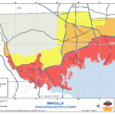
Wakulla County Evacuation Zones Map
from Wakulla County Sheriffs Office

We have heard the complaints regarding the confusion when reading the Wakulla County Evacuation Map.
Zone A (the red zone) includes all residences SOUTH of Hwy 98/Coastal Highway. By South of Hwy 98/Coastal Hwy we mean south of the road or if you are on the side nearest the coast. This zone includes all of Panacea, Ochlocknee Bay, Mashes Sands Road, Surf Road, Shell Point, Live Oak Island, St. Marks, New Port, and the southern part of Sopchoppy on Hwy 319. This also includes any low lying areas and mobile homes near these locations.
Zones B & C are everything north of those areas listed.
There is a Mandatory Evacuation Order in place for Zone A and a Voluntary Evacuation Order in place for Zones B & C.
The simple way to look at it is if you are close to Zone A or aren't quite sure if you are directly in it....EVACUATE.


