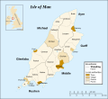
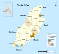
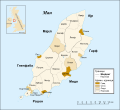
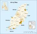
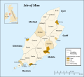
Bestand:IsleOfMan SheadingsAndParishes-en.svg
Uiterlijk

Afmetingen van deze voorvertoning van het type PNG van dit SVG-bestand: 654 × 600 pixels Andere resoluties: 262 × 240 pixels | 524 × 480 pixels | 838 × 768 pixels | 1.117 × 1.024 pixels | 2.234 × 2.048 pixels | 1.200 × 1.100 pixels.
Oorspronkelijk bestand (SVG-bestand, nominaal 1.200 × 1.100 pixels, bestandsgrootte: 222 kB)
Bestandsgeschiedenis
Klik op een datum/tijd om het bestand te zien zoals het destijds was.
| Datum/tijd | Miniatuur | Afmetingen | Gebruiker | Opmerking | |
|---|---|---|---|---|---|
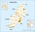
| huidige versie | 17 jan 2008 13:48 |  | 1.200 × 1.100 (222 kB) | Sémhur | Update |
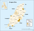
| 29 mei 2007 21:36 |  | 1.200 × 1.100 (356 kB) | Sémhur | {{Information |Description=Map in english of the Isle of Man, with bounds of sheadings, towns, villages, districts and parishes. |Source=Own work. Based on maps Image:Isle of Man map-fr.svg, [[:Image:Isle_of_Man_cities_villages.pn |
Bestandsgebruik
Dit bestand wordt op de volgende pagina gebruikt:
Globaal bestandsgebruik
De volgende andere wiki's gebruiken dit bestand:
- Gebruikt op av.wikipedia.org
- Gebruikt op en.wikipedia.org
- Gebruikt op eu.wikipedia.org
- Gebruikt op fi.wikipedia.org
- Gebruikt op frr.wikipedia.org
- Gebruikt op gd.wikipedia.org
- Gebruikt op gv.wikipedia.org
- Gebruikt op gv.wiktionary.org
- Gebruikt op it.wikipedia.org
- Gebruikt op ja.wikipedia.org
- Gebruikt op kk.wikipedia.org
- Gebruikt op ky.wikipedia.org
- Gebruikt op pl.wikipedia.org
- Gebruikt op ru.wikipedia.org
- Gebruikt op sk.wikipedia.org
- Gebruikt op stq.wikipedia.org
- Gebruikt op uz.wikipedia.org
- Gebruikt op xmf.wikipedia.org
- Gebruikt op zh.wikipedia.org

