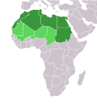
Talaksan:LocationNorthernAfrica.png
Itsura
LocationNorthernAfrica.png ((359 × 359 pixel, laki ng talaksan: 8 KB, uri ng MIME: image/png))
Nakaraan ng file
Pindutin ang araw/oras upang makita kung papaano ang itsura ng talaksan noong oras na iyon.
| Araw/Oras | Thumbnail | Mga dimensiyon | tagagamit | Kumento | |
|---|---|---|---|---|---|
| ngayon | 13:16, 11 Nobyembre 2022 |  | 359 × 359 (8 KB) | ColorfulSmoke | . |
| 11:54, 11 Nobyembre 2022 |  | 360 × 359 (8 KB) | ColorfulSmoke | ||
| 16:57, 17 Marso 2018 |  | 360 × 392 (10 KB) | Maphobbyist | Montenegro border | |
| 18:19, 10 Pebrero 2014 |  | 360 × 392 (8 KB) | Knyaz-1988 | New version | |
| 05:05, 12 Enero 2013 |  | 360 × 392 (13 KB) | Kuohatti | Reverted to version as of 21:04, 9 July 2011. According to http://unstats.un.org/unsd/methods/m49/m49regin.htm#africa UN doesn't count South Sudan in North Africa. | |
| 12:47, 20 Hulyo 2011 |  | 360 × 392 (8 KB) | Kahusi | See http://unstats.un.org/unsd/methods/m49/m49regin.htm | |
| 21:04, 9 Hulyo 2011 |  | 360 × 392 (13 KB) | Maphobbyist | South Sudan has become independent on July 9, 2011. Sudan and South Sudan are shown with the new international border between them. | |
| 18:55, 27 Mayo 2009 |  | 360 × 392 (14 KB) | Elmondo21st | Reverted to version as of 08:13, 11 December 2007 | |
| 18:13, 5 Abril 2009 |  | 360 × 392 (14 KB) | Elmondo21st | The map of the northern Africa is about 5 main countries; Morocco, Algeria, Tunisia, Libya and Egypt. The greater northern Africa includes the Sahara countries among them Sudan. | |
| 08:13, 11 Disyembre 2007 |  | 360 × 392 (14 KB) | Hoshie | added Cabinda (Angola) |
Mga ugnay
Nakaturo sa talaksan na ito ang mga sumusunod na mga pahina:
Pandaigdigang paggamit sa file
Ginagamit ng mga sumusunod na wiki ang file na ito:
- Paggamit sa ace.wikipedia.org
- Paggamit sa af.wikipedia.org
- Paggamit sa als.wikipedia.org
- Paggamit sa am.wikipedia.org
- Paggamit sa ar.wikipedia.org
- ليبيا
- جيبوتي
- موريتانيا
- تونس
- السودان
- الصحراء الغربية
- أنغولا
- أوغندا
- إسبانيا
- تشاد
- النيجر
- مالي
- السنغال
- غامبيا
- غينيا بيساو
- غينيا
- سيراليون
- ليبيريا
- غانا
- توغو
- بنين
- بوركينا فاسو
- الصومال
- كينيا
- تنزانيا
- الغابون
- زامبيا
- موزمبيق
- زيمبابوي
- البرتغال
- الكاميرون
- جمهورية الكونغو الديمقراطية
- بوتسوانا
- جنوب إفريقيا
- جمهورية إفريقيا الوسطى
- جمهورية الكونغو
- سيشل
- ناميبيا
- مدغشقر
- ليسوتو
- موريشيوس
Tingnan ang karagdagang pandaigdigang paggamit sa file na ito.


