News

- Local
- Nation & World
- ABC15 Investigates
- Offbeat
- Good Morning Carolinas
- The Surfboard
- Trabajando Por Ti
- Climate Carolinas
- Addicted Carolinas
- Back To School
- Crisis in the Classroom
- Election
- Entertainment
- Connect To Congress
- Armstrong Army Strong
- Inside Your World
- Soar
- Spotlight on America
- Healthy Home
- State
- Full Measure with Sharyl Attkisson
- Did You Know?
- Election Results
Weather
Spotlight
Traffic
Game Center
Moneynew
Chime In
About ABC 15
Sports
Lawmakers
Legal
Warmer pattern expected to end January & begin February

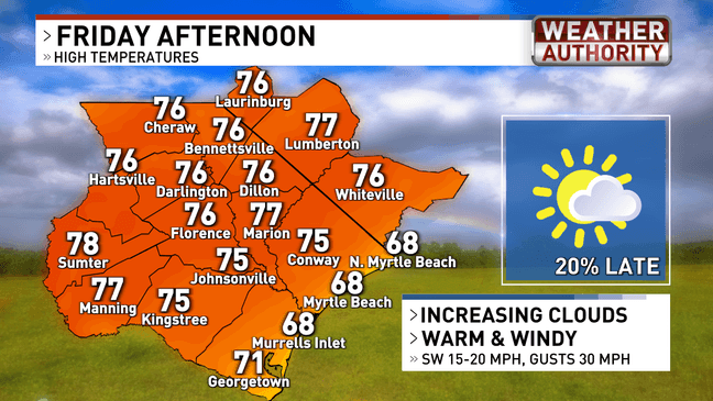
(WPDE) — The week ends on a very warm note. Friday is set to be the warmest day we've experienced so far in 2025.
The Pee Dee and Border Belt are likely to reach the mid to upper 70s Friday afternoon, with the low 70s likely in the western Border Belt and the Grand Strand. A community or two at the coast may stay in the upper 60s given cloud cover.

Rain chances will be elevated for Friday night into Saturday before dawn. Expect lows to fall to near 50 degrees with showers very likely.
NEW: Early morning earthquake recorded Monday off Maine coastline
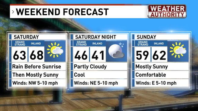
The weekend will be a bit cooler, but still mild and dry with highs in the lower 60s for both Saturday and Sunday with partly sunny skies.

TRENDING: 1 injured in Florence shooting; suspect's vehicle identified
For more local weather information, download our 'WPDE WX' App, available on iOS and Android.