A storm will bring strong winds, heavy rain, possible power outages to NC on Tuesday
N.C. Gov. Roy Cooper declared a state of emergency as a winter storm that will affect much of the East Coast over the next several days will bring heavy rain and strong winds to the state on Tuesday.
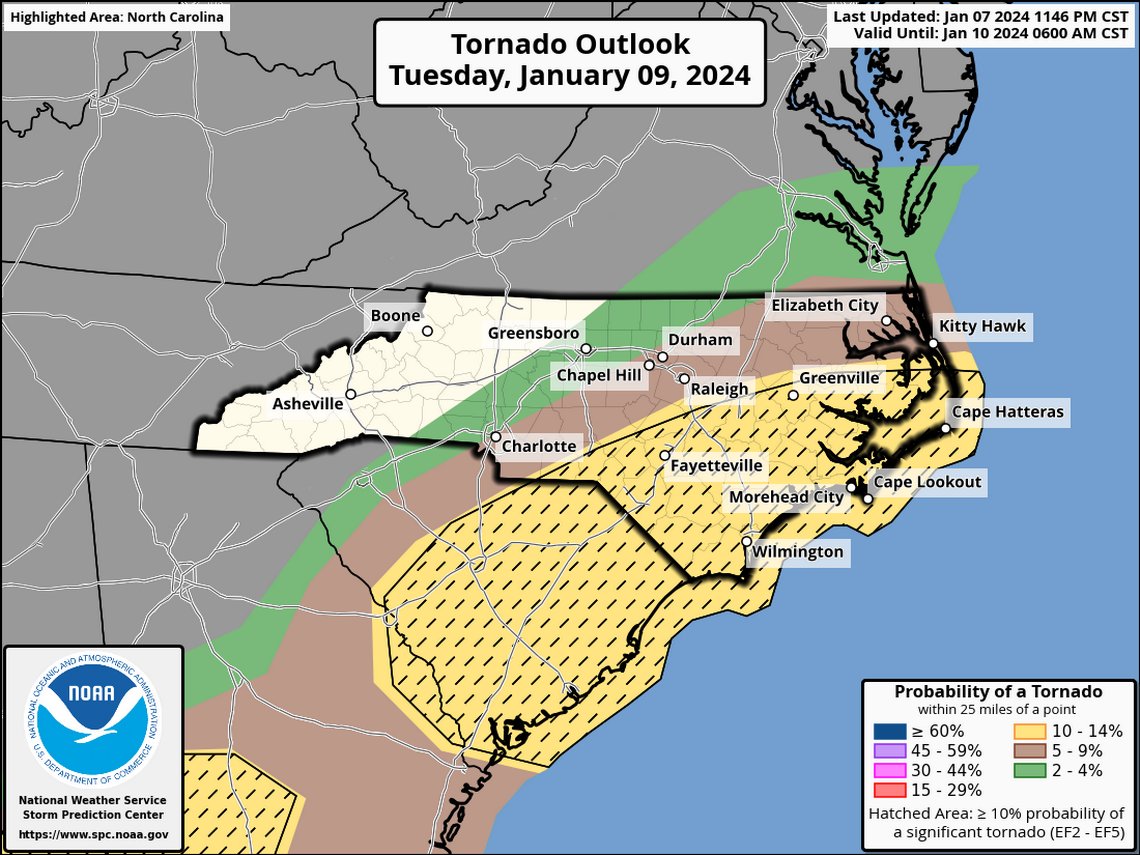
Thunderstorms are possible and in the Southeastern part of the state, from the Sandhills to the coast, there is a slight chance of tornadoes, especially Tuesday afternoon and evening.
School districts throughout the Triangle and Eastern North Carolina announced early dismissals or remote learning for Tuesday.
Cooper’s order loosens restrictions for trucks, including their weight, size and hours of service, so they can expedite their deliveries of essential supplies.

How much rain will NC get?
The area from Burlington to Goldsboro, including Raleigh, Durham and Chapel Hill, can expect at least 1.5 inches of rain from late Monday night through Tuesday night, the National Weather Service said. Flash flooding is possible in low-lying areas and those that don’t drain well.
Monday afternoon, the Weather Service issued a flood watch for the Piedmont and western Sandhills in central North Carolina, effective from Tuesday morning to Tuesday evening.
The western Piedmont, including Greensboro and Winston-Salem, is likely to see about 2 inches of rain total, according to forecasts.
The Weather Service said 3 inches total could fall in areas that get heavy local downpours.
The central and southern mountains could see even more rain, forecasters said Monday night, with 3 to 5 inches expected in the area from Haywood County, on the Tennessee border, north to Avery County and east to Gaston, which is adjacent to Mecklenburg.

Early school dismissals
Wake County Schools will release three hours early on Tuesday.
Durham County Public Schools will dismiss Tuesday on the following schedule: elementary schools at 10:45 a.m., middle and secondary schools at 11:50 a.m. and high schools at 12:45 p.m.
Chapel Hill-Carrboro City Schools will have a three-hour early dismissal Tuesday on the following schedule: elementary schools at 11:35 a.m., middle schools at 12:20 p.m. and high schools at 1 p.m. Fields trips and after-school activities and athletics are postponed or canceled. After-school care is canceled.
Orange County Schools will have a three-hour early dismissal Tuesday on the following schedule: elementary schools at 11:30 a.m., middle schools at 12:25 p.m. and high schools at 1 p.m.
Johnston County Schools will also release three hours early for all students, staff and visitors.
Cumberland County Schools announced students will be let out two hours early on Tuesday because of the potential bad weather.
Lee County Schools will shift to remote learning on Tuesday and all after-school activities for the day are postponed.
Triangle area schools will release early on Tuesday because of severe weather
Could there be snow or sleet?
In the mountains, forecasters said, the storm could start with snow, sleet or freezing rain, with accumulations up to two-tenths of an inch, but that should turn to rain in the early morning.
The rest of the state is expected to get only rain, with temperatures rising into the 60s in eastern counties through the day Tuesday.

Strong wind could cause power outages
All of central North Carolina will be under a wind advisory on Tuesday, with winds gradually increasing through the day. Winds are expected to peak between 2 p.m. and 10 p.m. Tuesday in the state’s midsection at 15 to 25 mph, with gusts up to 45 mph.
The strongest gusts are expected over the southern Piedmont, the Sandhills and the southern Coastal Plain.
Forecasters say the gusts could be strong enough to blow around unsecured objects — Christmas inflatables and uncollected holiday trash, for example — and tree limbs could be blown down.
Along the coast, the Weather Service said Monday night, the storm’s greatest impact will be high winds, with speeds that could reach or exceed records for this time of year. Areas east of U.S. Highway 17 could see gusts of 60 to 70 mph or more, possibly resulting in coastal flooding and ocean overwash. Frequent gusts of 45 o 66 mph should be expected, forecasters said.

Power outages are possible.
In the western part of the state, a wind advisory has been issued for 7 p.m. Monday until 7 p.m. Tuesday. The Weather Service predicts Southeast winds of 20 to 30 mph with gusts up to 55 mph.
Thousands remain without power after storm rolls through NC. Schools announce delays
Don’t drive through floodwaters + other tips for staying safe during heavy rain storms
