Grid reference SP4405
near to Farmoor, Oxfordshire, England
Coverage
We have
23 images
in grid square SP4405
Contribute
Explore gridsquare SP4405
Surrounding area
Maps
TIP: Click the map for more Large scale mapping
Tip: Click the map to open the coverage map
Sample images
Breakdown list
A sample of 12 photos from 23
for SP4405
- View this square in the Browser >>>

|
Raised footpath through Bushy Leaze Copse
The Countryside Walk stretches for 4.5 miles around Farmoor Reservoir.
|

|
Farmoor Reservoir |

|
Farmoor Reservoir
by Alan Ford
Taken from close by Upper Whiteley Farm on the Long Leys track, Cumnor
|

|
Farmoor Reservoir, Farmoor, Oxon
This is the southern part of the reservoir. It seems quite full at present. In the foreground is a great crested grebe. See this image for what one looks like close up: Link In the background just to the... (more)
|

|
Farmoor Reservoir
Farmoor Reservoir II, small jetty at the Southern edge
|
|
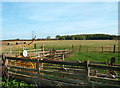
Weighing Machine in a Field
This looks like they've been weighing sheep or something.
Pasture south of Farmoor Reservoir.
The wood on the horizon is Whitley Brake.
|

|
Bushy Leaze Copse
by Tom Pullman
The "other" geographical feature in the square, as I couldn't get high enough up the embankment (due to a fence) to photograph the reservoir...
|

|
Picnic area at Farmoor Reservoir
View at the southern end of the reservoir.
|

|
Farmoor Reservoir Picnic Area under snow
by Brian Walker
This is a picture, taken from Lower Whitley Farm road, looking over the picnic area towards the sailing club.Farmoor Reservoir January 2010.
|

|
Footpath to the River Thames
The Countryside Walk stretches for 4.5 miles around Farmoor Reservoir.
|

|
Footpath to Lower Whitley Farm
The Countryside Walk stretches for 4.5 miles around Farmoor Reservoir.
|

|
The southern end of Farmoor Reservoir |
Explore more images in this square: | View Filtering options | View all 23 images page by page >>> |
|