Grid reference SX0382
near to Treligga, Cornwall, England
Coverage
We have
52 images
in grid square SX0382
Contribute
Explore gridsquare SX0382
Surrounding area
Maps
TIP: Click the map for more Large scale mapping
Tip: Click the map to open the coverage map
A sample of 12 photos from 52
for SX0382
- View this square in the Browser >>>
|
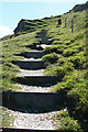
St Teath: steps in the path
On the coast path. The way out of the valley below Tregragon is steep!
|
|
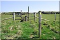
Footpath to Dannonchapel
by Tony Atkin
The footpath leaves the coast path and heads inland via Dannonchapel, eventually reaching the road.
|
|
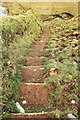
Steps on the coast path near Crookmoyle Rock
by Derek Harper
Looking back down a murderous conclusion to a strenuous climb up 60 metres from the footbridge shown in SX0382 : Footbridge near Jacket's Point. Four consecutive valleys are crossed by the coast path in just over two kilometres, quite the most brutal stretch of the... (more)
|
|
Spring on its way to the sea |
|
Cornish coast, Port Isaac Bay |
|
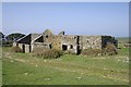
Ruined Farm Buildings at Dannonchapel
by Tony Atkin
|
|
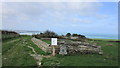
Dannonchapel |
|
Coast path near Dannonchapel
by Derek Harper
This descent and ascent is by no means the worst of the five that come in quick succession on a murderous two kilometres or so of coast path. Delabole Point is the dark headland a little ahead, with Port Isaac in the distance.
|
|
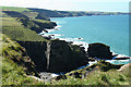
Cornish coast from above Crookmoyle Rock
Rugged Cornish coast on Port Isaac Bay.
|
|
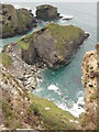
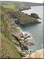
St Teath: a cove or inlet
A dramatic break in the cliffs, not named on the Ordnance Survey 1:25,000 map, seen from the coast path and inaccessible from it
|
|
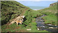
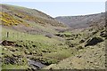
Looking Upstream
by Tony Atkin
Looking upstream from the coast path along the valley which runs to the south of Dannonchapel.
|
|
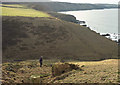
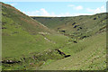
St Teath: valley below Tregragon
A link path runs up the valley to the farm and Westdowns on the B3314 road
|
Explore more images in this square: | View Filtering options | View all 52 images page by page >>> |
|