NS1966 : Flood gate
taken 18 years ago, near to Skelmorlie, North Ayrshire, Scotland
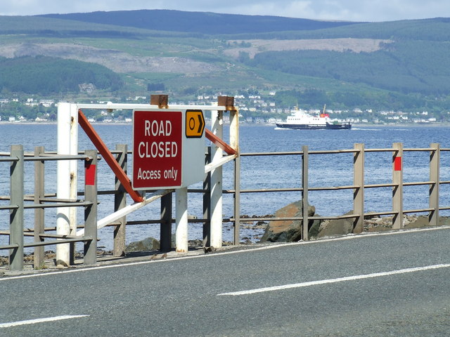
The vessel in the background is MV Argyle which is en-route from Wemyss Bay to Rothesay on the Isle of Bute.
Two sections of the A78 south of Wemyss Bay and north of Largs are prone to closure when tide and weather combine to flood the road with not just seawater, but an array of rocks, seaweed and floating debris. The affected sections run directly along the Firth of Clyde coast, with nothing but metal railings to separate the road from the sea for much of the way. High tide and storm surges can cause the road to flood occasionally, but the real threat to road safety comes when a high wind is added to the mix.
Each section has two gates, one at each end, which block the lane into the section, leaving the exit lane from the section free. The distance between the two sections is only around 700m.
Depending on the severity of the flooding, access to properties in the closed sections is sometimes possible, especially in the non-coastal sections.
The Skelmorlie Section
--------------------------
The Skelmorlie Section runs for around 1300m from The Hydro Steps in Skelmorlie to the junction with Eglinton Terrace. Around 100m of this section runs along the sea wall.
The first gate in the Skelmorlie section is encountered when heading south from Wemyss Bay, immediately beyond a small turning circle on the east side of the road in Skelmorlie. This turning circle can be used by A78 south bound traffic to return north and use the appropriate diversion (depending on the type of vehicle) if the flood gate is closed.
The second gate in the Skelmorlie section is encountered at the last house in the south end of Skelmorlie. Eglinton Terrace provides a detour route through Upper Skelmorlie to the first gate.
The North Largs Section
---------------------------
The North Largs Section runs for around 5300m from the junction with Meigle Road, south of Skelmorlie, to the junction with Routenburn Road at the former Netherhall Lodge. Not all of this section is directly on the sea, but the extents of the section are also determined by the available detour roads.
The first gate in the North Largs section is encountered when heading south from Skelmorlie. Meigle Road, which has a ninety degrees bend and 20% gradient within the first 300m, is the only available detour on this section. However, probably only small vehicles will have made it this far south through the Skelmorlie section anyway.
The second gate in the North Largs section is encountered just after the bridge over Noddsdale Water at Routenburn Road.
Routenburn Road is the south end of the diversion which begins at Meigle Road.
- Grid Square
- NS1966, 80 images (more nearby 🔍)
- Photographer
- Thomas Nugent (more nearby)
- Date Taken
- Monday, 21 May, 2007 (more nearby)
- Submitted
- Tuesday, 22 May, 2007
- Subject Location
-
OSGB36:
 NS 192 662 [100m precision]
WGS84: 55:51.3165N 4:53.3765W - Camera Location
-
OSGB36: NS 192 662
- View Direction
- Northwest (about 315 degrees)