Your search for images, within 10km of grid reference SP3073, in canonical category Industrial site, returns
30 images:
( Page 1 2 next >> last ) [refine search]
[quick refine]
[We have no images for SP3073, Submit Yours Now!]

|
Industrial units, Canley
by E Gammie geograph for square SP3077 Dist:4.4km north Category: Industrial area Tags: [top:Energy infrastructure] [top:Industry] [top:Railways] [pylons] Industrial units flank the north and south sides of the Coventry to Birmingham railway line. Those on the northern side are on the former Standard-Triumph car plant site,... (more)
|
|
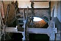
Mill wheel pit
by Colin Craig for square SP3169 Dist:4.4km south-southeast Category: Mill Remains of the wheel pit at Blackdown Mill near Leamington Spa. The building has been converted to housing but parts of the mill wheel remain in situ and are visible from the road.
|
|
Coventry-Lower Stoke
by Ian Rob geograph for square SP3478 Dist:6.3km northeast Category: Industrial area Looking along Terry Road. The factory building on the left is now a depot for industrial gas containers. The railway bridge carried the old Coventry loop line which... (more)
|

|
The gas works
by E Gammie geograph for square SP3279 Dist:6.3km north-northeast Category: Industrial area Tags: [top:City, Town centre] [top:Energy infrastructure] [top:Roads, Road transport] [gas] [bucket:Gone] [ring road] The site in the foreground has been associated with gas production/supply since 1824, when Coventry Gas Works first occupied it. Production moved to the Foleshill gas... (more)
|

|
Wheatley Street Flour Mills, Coventry, 1983
by John Brightley geograph for square SP3379 Dist:6.8km north-northeast Category: Mill This view is from Cox Street looking along Wheatley Street towards the ring road.
The former Goodwin Foster Brown flour mills had been derelict for a number of years... (more)
|

|
Behind the facade
by John Evans geograph for square SP2779 Dist:6.9km north-northwest Category: Industrial site (derelict) This is the back entrance (from Broad Lane) to the former Massey Ferguson Works, Coventry. Although the facade of the offices (and the tower block) facing Banner Lane... (more)
|

|
Leamington Brewery of Lucas, Blackwell and Arkwright
by David Stowell geograph for square SP3166 Dist:7.0km south Category: Brewery By now closed and used as a council storage depot however the name can still be seen in the stonework at the top of the main building. Compare with SP3166 : Leamington Brewery - now The Maltings
|

|
Ryton On Dunsmore
by Ian Rob geograph for square SP3774 Dist:7.3km east Category: Industrial site (derelict) Demolition at the former Peugeot Plant.
|

|
Ryton-Former Peugeot Plant
by Ian Rob geograph for square SP3774 Dist:7.4km east Category: Industrial site (derelict) Demolition of the former Car Plant is in progress. Part of the site is to be developed for warehousing.
|

|
Rock Mill
by David Stowell geograph for square SP3066 Dist:7.4km south Category: Mill In the 1790s there was a water powered cotton mill on this site beside the Avon in Milverton. This was subsequently converted to the production of flour and, to overcome... (more)
|

|
The back end of Ryton car plant
by E Gammie geograph for square SP3873 Dist:7.8km east Category: Industrial site (derelict) Tags: [top:Derelict, Disused] [top:Industry] [top:Suburb, Urban fringe] [formerly vehicle manufacturing] taken between the bars of the security fencing (see SP3873 : Defunct car plant - keep out ). This end has been scrubland like this for some years. Beyond it can be seen the car parks where new... (more)
|

|
Webster's chimney
by E Gammie geograph for square SP3480 Dist:7.9km north-northeast Category: Industrial area Tags: [top:Industry] [brickworks] [chimney] The chimney at the old Webster's brick works off Stoney Stanton Road.
|

|
Defunct car plant - keep out
by E Gammie for square SP3873 Dist:7.9km east Category: Industrial site (derelict) Tags: [top:Derelict, Disused] [top:Industry] [top:Suburb, Urban fringe] [formerly vehicle manufacturing] This is the back end of the Ryton car plant after closure by Peugeot. The sign has wording to the effect of " This land is the property of Peugeot Citroen UK Ltd.... (more)
|

|
Site of Emscote Mill
by David Stowell geograph for square SP2965 Dist:8.0km south Category: Mill The mainly bricked up arches under the towpath of the Grand Union Canal are about the only evidence that the modern block of flats occupies the site of what was once... (more)
|

|
A452 Europa Way, Warwick
by Robin Stott for square SP3165 Dist:8.4km south Category: Foundry Ford's Foundry has greeted visitors to Leamington, the Regency spa town, for decades.
Its closure in 2008 caused much heartache. See it in a better light at... (more)
|
Search took 0.02 secs, ( Page 1 2 next >> last ) [refine search]
View/Download: KML geo RSS GPX Try opening in Browser function (Experimental, may not work!)Expand Word Statistics
Found these results useful? Please Donate
|