Your search for images, within 10km of grid reference TQ3453, in canonical category View, returns
90 images:
( Page 1 2 3 4 5 6 next >> last ) [refine search]
[quick refine]
|
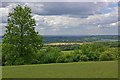
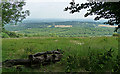
Caterham Viewpoint
by Ian Capper geograph for square TQ3453 Dist:0.3km Category: Viewpoint Looking south from Caterham Viewpoint on Gravelly Hill, with North Park Quarry prominent (producing high quality sand), beyond which is Bletchingley Golf Course and... (more)
|
|
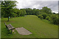
Caterham Viewpoint
by Ian Capper geograph for square TQ3453 Dist:0.3km Category: Viewpoint A small open area on Gravelly Hill with views to the south (see TQ3453 : Caterham Viewpoint).
|
|
Caterham Viewpoint
by Ian Capper geograph for square TQ3453 Dist:0.4km Category: Viewpoint A small open area on Gravelly Hill with views to the south (see TQ3453 : Caterham Viewpoint).
|
|
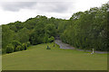
North Downs viewpoint near Caterham
by Andrew Hill geograph for square TQ3453 Dist:0.4km Category: Viewpoint Looking across Surrey from the top of the downs.
|
|
|
Enjoying the View, Near Caterham
by Hywel Williams geograph for square TQ3453 Dist:0.4km Category: Viewpoint A couple enjoy the view from this viewpoint near Caterham.
|

|
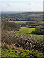
View Point on the North Downs Near Caterham
by Hywel Williams geograph for square TQ3453 Dist:0.4km Category: Viewpoint Some stunning views are seen off the edge of the North Downs from this viewing area. The line of trucks that can be seen in the middle distance is the M25, snarled up... (more)
|

|
View from North Downs Way
by Robin Webster geograph for square TQ3553 Dist:1.1km east Category: View The shed at centre middle distance belongs to Godstone Vineyards. Vines are growing in the lighter green fields nearby.
|

|
Fields and woodland in rural Surrey
by Peter S for square TQ3654 Dist:1.8km east-northeast Category: Rural scene |

|
A view across the valley from near Winders Hill
by Peter S geograph for square TQ3654 Dist:1.9km east-northeast Category: Rural scene |

|
Surrey hills near to Caterham
by Peter S for square TQ3555 Dist:2.0km north-northeast Category: Rural scene Zoom shot of fields in rural Surrey with some London landmarks on the distant horizon.
|

|
Marden Park in Surrey
by Peter S geograph for square TQ3654 Dist:2.1km east-northeast Category: Rural scene A view to the south of Woldingham School across fields and woodland.
|

|
Fields and woods south of the school
by Peter S geograph for square TQ3654 Dist:2.2km east-northeast Category: Rural scene |
|
View from Tandridge Hill
by Stephen Richards geograph for square TQ3653 Dist:2.5km east Category: View Looking down the slope of the hill, across the High Weald.
The High Weald is designed as an Area of Outstanding Natural Beauty, covering some 150,000 hectares from... (more)
|

|
Terrace view of the Woldingham area
by Peter S for square TQ3655 Dist:3.0km northeast Category: Rural scene |

|
View from the greensand ridge
by Robin Webster geograph for square TQ3151 Dist:3.7km west-southwest Category: View Towards the North Downs on the skyline. Quite close behind the trees ahead is the M23.
|
Search took 0.16 secs, ( Page 1 2 3 4 5 6 next >> last ) [refine search]
View/Download: KML geo RSS GPX Try opening in Browser function (Experimental, may not work!)Expand Word Statistics
Found these results useful? Please Donate
|