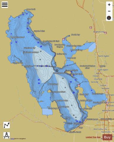
Great Salt Lake fishing map is available as part of iBoating : USA Marine & Fishing App(now supported on multiple platforms including Android, iPhone/iPad, MacBook, and Windows(tablet and phone)/PC based chartplotter.).
With our Lake Maps App, you get all the great marine chart app features like fishing spots, along with Great Salt Lake depth map. The fishing maps app include HD lake depth contours, along with advanced features found in Fish Finder / Gps Chart Plotter systems, turning your device into a Depth Finder. The Great Salt Lake Navigation App provides advanced features of a Marine Chartplotter including adjusting water level offset and custom depth shading. Fishing spots, Relief Shading, Lake Temperature and depth contours layers are available in most Lake maps. Lake navigation features include advanced instrumentation to gather wind speed direction, water temperature, water depth, and accurate GPS with AIS receivers(using NMEA over TCP/UDP). Autopilot support can be enabled during ‘Goto WayPoint’ and ‘Route Assistance’.
Now i-Boating supports Fishing Points in Great Salt Lake.
Have more questions about the Nautical Chart App? Ask us.
Fishing Info for Great Salt Lake
The Great Salt Lake is the largest saltwater lake in the Western Hemisphere and the eighth-largest terminal lake in the world. It lies in the northern part of the U.S. state of Utah and has a substantial impact upon the local climate, particularly through lake-effect snow. It is a remnant of Lake Bonneville, a prehistoric body of water that covered much of western Utah. The area of the lake can fluctuate substantially due to its low average depth of 16 feet (4.9 m). In the 1980s, it reached a historic high of 3,300 square miles (8,500 km2), and the West Desert Pumping Project was established to mitigate flooding by pumping water from the lake into the nearby desert. In 2021, after years of sustained drought and increased water diversion upstream of the lake, it fell to its lowest recorded area at 950 square miles (2,460 km²), falling below the previous low set in 1963. Continued shrinkage could turn the lake into a bowl of toxic dust, poisoning the air around Salt Lake City. The lake's three major tributaries, the Jordan, Weber, and Bear rivers together deposit around 1.1 million tons of minerals in the lake per year. Since the lake has no outlet besides evaporation, these minerals accumulate and give the lake high salinity (far saltier than seawater) and density. This density causes swimming in the lake to feel similar to floating. The lake has been called "America's Dead Sea" and provides a habitat for millions of native birds, brine shrimp, shorebirds, and waterfowl, including the largest staging population of Wilson's phalarope in the world.
More on Wikipedia...Great Salt Lake Fishing Map Stats | |
| Title | Great Salt Lake |
| Sailing Clubs in this Chart region | |
| Great Salt Lake Yacht Club | |
| The Great Salt Lake Yacht Club | |
| Scale | 1:24000 |
| Counties | Box Elder, Davis, Salt Lake, Tooele, Weber |
| Nearby Cities | Lakeside, Willard, Farmington, West Bountiful, Burmester, Centerville, Kaysville, West Point, Perry, Hooper |
| Area * | 1055863.63 acres |
| Shoreline * | 790.90 miles |
| Min Longitude | -113.06 |
| Min Latitude | 40.67 |
| Max Longitude | -111.91 |
| Max Latitude | 41.70 |
| Edition Label 1 | |
| Edition Label 2 | |
| Edition Label 3 | |
| Id | US_UT_01441459 |
| Country | US |
| Projection | Mercator |
| * some Stats may include nearby/connecting waterbodies | |
|


