City map

Discover Pinterest’s best ideas and inspiration for City map. Get inspired and try out new things.
26k people searched this
·
Last updated 1w
a city map with cars, buildings and street lights on the streets in different colors

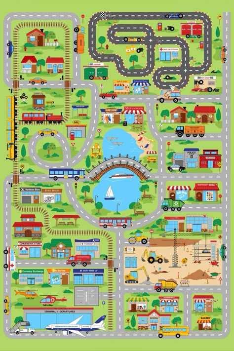
What we have here, is a city map or town map depicting the various places and locations pictorially. Different symbols or icons are used to show the locations of the places. For example, the icon of a car is used to show the car park, the icon of a building shows a police station or a museum or a cinema or city hall. It is a colorful city or town map that uses green color in order to show trees, a park, or a playground. The roads are colored grey and bear the names of the streets as well…

1.7k
a map showing the locations of different buildings and streets in this city, including shops, restaurants

GIVING DIRECTIONS IS EASY!!! BUT YOU HAVE TO GIVE THE APPROPRIATE INFORMATION AND BE CLEAR!!! Have a look at this map and read the appropriate way to give directions. The Oral Exam is already here!!!! DIALOGUE 1 Excuse me, can you tell me the way to the café, please? Yes, of course. Go straight on and turn left at the car park. Go straight on and turn right at the museum. Go straight on the Second Avenue and turn left at the hotel. The cafe is next to the cinema, opposite the hotel. Thank…

889
an aerial view of a city with lots of buildings and streets in blue ink on white paper

Hand drawn city map of Raalte (called after some Dutch town). The city is situated on two rivers, on of them being an affluent, ending in the other. It's drawn as a city as it could have grown in multiple centuries: city center, former bastions, station close to the river side, apparment buildings from the 70s and newer neighbourhoods surrounding the city. In a word: a very European city. Why it is called Raalte? Well, I just like place names ending on -e and after having made up twenty of…

18k

Related interests