Fire Presentation.pptx
- 1. Forest Fire Distribution and Risk Zonation of Province 1 A Research Proposal Presentation on Presenter : Raj Kumar Shrestha B.Sc. 4th year 1st semester Purbanchal University College of Environment and Forestry Advisor: Prabin Pandit Lecturer Department of Silviculture and Forest Biology
- 2. Outline of the Presentation Introduction Rationale of study Objectives Methodology Expected Outcomes Time and Budgeting References 2
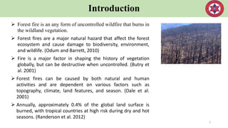
- 3. Introduction Forest fire is an any form of uncontrolled wildfire that burns in the wildland vegetation. Forest fires are a major natural hazard that affect the forest ecosystem and cause damage to biodiversity, environment, and wildlife. (Odum and Barrett, 2010) Fire is a major factor in shaping the history of vegetation globally, but can be destructive when uncontrolled. (Butry et al. 2001) Forest fires can be caused by both natural and human activities and are dependent on various factors such as topography, climate, land features, and season. (Dale et al. 2001) Annually, approximately 0.4% of the global land surface is burned, with tropical countries at high risk during dry and hot seasons. (Randerson et al. 2012) 3
- 4. Introduction In Nepal, forest fires are a common and significant threat to the forest cover. The highest density of forest fire in Nepal was in the Terai region with 6.4 hectares burnt per km2. (Bhujel et al. 2017) In 2016, there was a high incidence of forest fires in Nepal resulting in a loss of 268,618 ha of forest cover during January-May. (Mandal 2019) Remote Sensing and GIS are quick, cheap, and reliable tools for monitoring and detecting forest fires. There have been limited studies on the spatial and temporal distribution and risk assessment of forest fires in Nepal. This study aims to map the forest fire prone areas in Province One of Nepal using Remote Sensing and GIS. 4
- 5. Rationale of Study The Department of Forests has recognized fire as a threat to ecosystems and biodiversity and has allocated budget for fire control. The mean annual temperature is increasing across the Terai and all four seasons are also warming up (Jones et al., 2004). The year 2009 was exceptionally disastrous with regard to forest fires in Nepal, with 358 fires occurring in a single day in April 25, 2009. A total of 49 persons, including 13 army personnel, died in 2009. In 2016, forest fires destroyed 1.3 million hectares of forest, and killed eleven people. Thousands of hectares of forest are destroyed by fire every year and produce more carbon monoxide than automobile traffic. Wildfire is emerging as burning issues in the present days of Province 1. 5
- 6. Rationale of Study Illam and Udayapur district are very high-risk forest fire zone (Martin et al, 2016). There is a lack of systematic and complete studies regarding forest fires within the province One. The purpose of this study is to establish baseline data on forest fire information and understand the causes, hotspots, and seasonality. The results of the study will assist in prediction of future forest fires, reducing damage and cost of firefighting, and preparation of fire strategies and plans. The study will also help ensure the preservation of wild vegetation and prevent introduction of invasive plants or diseases through fire suppression. 6
- 7. Rationale of Study General objective: The general objective of this study is to analyse spatial and temporal forest fire trends and susceptibility of Province One, Nepal. Specific objective: To compare the magnitude and temporal distribution pattern of forest fires in Province 1. To identify the driving factors of forest fire incidence. To prepare forest fire risk zonation map. Research question What is the distribution pattern, trend, factors responsible and major consequences of forest fire? What are the challenges in controlling forest fire? 7
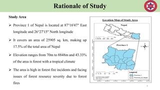
- 8. Rationale of Study Study Area Province 1 of Nepal is located at 87°16'47" East longitude and 26°27'15" North longitude It covers an area of 25905 sq. km, making up 17.5% of the total area of Nepal Elevation ranges from 70m to 8848m and 43.33% of the area is forest with a tropical climate The area is high in forest fire incidents and facing issues of forest resource severity due to forest fires 8
- 9. Methodology Data collection Primary data collection The primary data collection will be done through Focus Group Discussion, Key informant, and direct field observation. Checklist and questionnaires will be prepared to achieve the research objectives and will be pre-tested for accuracy. Biophysical data will be collected through randomly chosen sample plots in the forest using the biomass inventory guideline. Field samples will be chosen in areas with homogeneous land-use and the sample size will be 100*100 meters. 9 Secondary data collection: The secondary data collection will be done through Fire Information for Resource Management System (FIRMS) MODIS data from NASA’s Terra and Aqua earth monitoring satellites will be used to extract the location, range, and distribution of fires. Nepal’s digital map, digital topographic map, elevation map, aspect map, slope map, proximity to road and settlement, land cover map, and forest types will be obtained from various departments. Meteorological data like rainfall, humidity, and temperature will be obtained from the Department of Hydrology and Meteorology.
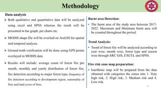
- 10. Methodology Data analysis Both qualitative and quantitative data will be analyzed using excel and SPSS whereas the result will be presented in bar graph, pie charts etc. MODIS shape file will be overlaid on ArcGIS for spatial and temporal analysis. Ground truth verification will be done using GPS points overlayed in MODIS data Results will include: average count of forest fire per month, monthly and yearly distribution of forest fire, fire detection according to major forest type, frequency of fire detection according to development region, seasonality of fires and land cover of fires. 10 Burnt area Detection: • The burnt area of the study area between 2017- 2022. Maximum and Minimum burnt area will be counted throughout the period. Trend Analysis: • Trend of forest fire will be analyzed according to year wise, month wise, forest type and season wise through ARC GIS, EXCEL and SPSS. Fire risk zone map preparation: • Isarithmic map will be prepared from the data obtained with categories the zones into 1. Very high risk, 2. High risk, 3. Medium risk and 4. Low risk.
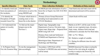
- 11. Methodology 11 Specific Objective Data Needs Data Collection Method(s) Method(s) of Data Analysis 1.To Identify trend and burnt area patterns of fire incidents. FIRMS Provide information on active fire using MODIS and ICIMOD provide information of active forest fire in Nepal ( Arc GIS 10.8) Will be used. Total burnt area and total count will be determined and trend will be analysis 2.To identify the Perception of People towards Forest Fire. To know which factor is creating more or less forest fire in the district. Primary (Focus Group Discussion including local representatives and CFUGS Members). Likert Scale will be used. 3 .To Understand risk pattern in Locality factors. To find out the major hotspot area in the Province 1. Digital map, Topographic map – Department of survey. Elevation map , Aspect map ,Slope map – Prepared from DEM Using GIS 10.8 Distance from road and Settlement – ICIMOD and Department of Survey. Metrological data- Department of Hydrology and Metrology. Martin et al 2017, will be used. In this study we use vegetation type, elevation , slope, temp., distance from road and settlement to calculate the Fire Risk Index. FRI= wi *Ci Where, Wi= Relative weight of variable. Ci= Rating for different class for each variables. 4 .To Prepare Forest Fire risk Zonation Map. To run the management plan accordingly. Secondary ( GPS Point will be overlayed in MODIS data and accuracy will be tested. MODIS historical Fire data is reclassify based on fire risk rating & weighted overlay to analysis the forest fire risk zonation map.
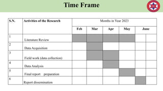
- 12. Time Frame S.N. Activities of the Research Months in Year 2023 Feb Mar Apr May June 1 Literature Review 2 Data Acquisition 3 Field work (data collection) 4 Data Analysis 5 Final report preparation 6 Report dissemination
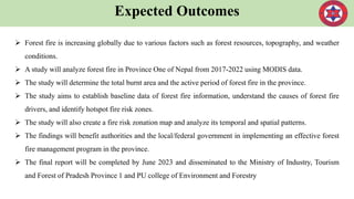
- 13. Expected Outcomes Forest fire is increasing globally due to various factors such as forest resources, topography, and weather conditions. A study will analyze forest fire in Province One of Nepal from 2017-2022 using MODIS data. The study will determine the total burnt area and the active period of forest fire in the province. The study aims to establish baseline data of forest fire information, understand the causes of forest fire drivers, and identify hotspot fire risk zones. The study will also create a fire risk zonation map and analyze its temporal and spatial patterns. The findings will benefit authorities and the local/federal government in implementing an effective forest fire management program in the province. The final report will be completed by June 2023 and disseminated to the Ministry of Industry, Tourism and Forest of Pradesh Province 1 and PU college of Environment and Forestry
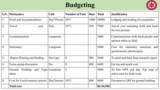
- 14. Budgeting S.N. Particulars Unit Number of Unit Rate Total Justification 1. Food and Accommodation Day*Person 20*1 1000 20000 Lodging and fooding for researcher. 2. Travel cost Trip 15*1 500 7500 Travel cost including field and local for two persons 3. Communication Lumpsum 1000 Communication with local people and advisor while in field. 4. Stationery Lumpsum 3000 Cost for stationery materials and questionnaire photocopies. 5. Report Printing and binding Set/copy 4 900 3600 To print and bind final research report 6. Focus group discussion No. 8 800 6400 For tea and snack cost 7. Ground Truthing and Topo sheet Lumpsum 5 5000 To hire GPS and buy Top map of entire area for field work 8. Cost for Local resource person Day*person 10*1 800 8000 Payment to LRP for ground truthing Total cost Rs.54,500
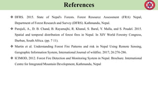
- 15. References DFRS. 2015. State of Nepal's Forests. Forest Resource Assessment (FRA) Nepal, Department of Forest Research and Survey (DFRS). Kathmandu, Nepal. Parajuli, A., D. B. Chand, B. Rayamajhi, R. Khanal, S. Baral, Y. Malla, and S. Poudel. 2015. Spatial and temporal distribution of forest fires in Nepal. In XIV World Forestry Congress, Durban, South Africa. (pp. 7 11). Martin et al. Understanding Forest Fire Patterns and risk in Nepal Using Remote Sensing, Geographic Information System, International Journal of wildfire. 2017; 26:276-286. ICIMOD, 2012. Forest Fire Detection and Monitoring System in Nepal. Brochure. International Centre for Integrated Mountain Development, Kathmandu, Nepal
