


River processes and landforms
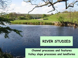
- 1. Channel processes and features Valley slope processes and landforms RIVER STUDIES
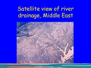
- 2. Satellite view of river drainage, Middle East
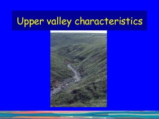
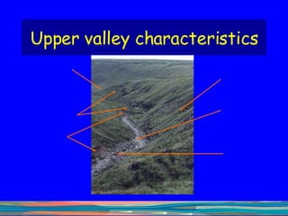
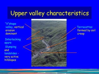
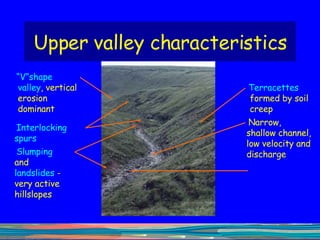
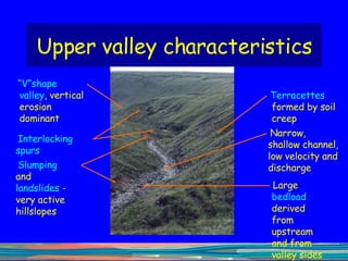
- 6. Upper valley characteristics “ V”shape valley , vertical erosion dominant
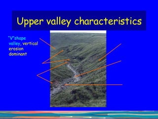
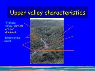
- 7. Upper valley characteristics “ V”shape valley , vertical erosion dominant Interlocking spurs
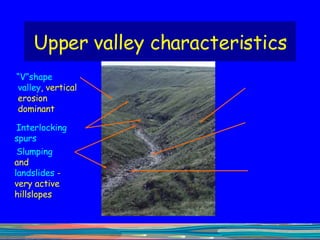
- 8. Upper valley characteristics “ V”shape valley , vertical erosion dominant Interlocking spurs Slumping and landslides - very active hillslopes
- 9. Upper valley characteristics “ V”shape valley , vertical erosion dominant Interlocking spurs Slumping and landslides - very active hillslopes Terracettes formed by soil creep
- 10. Upper valley characteristics “ V”shape valley , vertical erosion dominant Interlocking spurs Slumping and landslides - very active hillslopes Terracettes formed by soil creep Narrow, shallow channel, low velocity and discharge
- 11. Upper valley characteristics “ V”shape valley , vertical erosion dominant Interlocking spurs Slumping and landslides - very active hillslopes Terracettes formed by soil creep Narrow, shallow channel, low velocity and discharge Large bedload derived from upstream and from valley sides
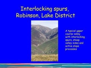
- 12. Interlocking spurs, Robinson, Lake District A typical upper course valley with interlocking spurs, steep valley sides and active slope processes
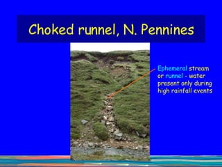
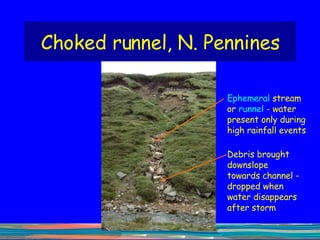
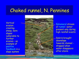
- 13. Choked runnel, N. Pennines Ephemeral stream or runnel - water present only during high rainfall events
- 14. Choked runnel, N. Pennines Debris brought downslope towards channel - dropped when water disappears after storm Ephemeral stream or runnel - water present only during high rainfall events
- 15. Choked runnel, N. Pennines Debris brought downslope towards channel - dropped when water disappears after storm Ephemeral stream or runnel - water present only during high rainfall events Vertical erosion creating steep, bare slopes vulnerable to further erosion - an example of positive feedback in a slope system
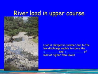
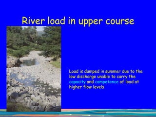
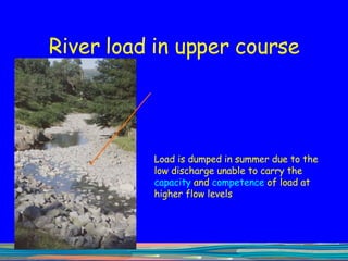
- 16. River load in upper course Load is dumped in summer due to the low discharge unable to carry the c ________ and c __________ of load at higher flow levels
- 17. River load in upper course Load is dumped in summer due to the low discharge unable to carry the capacity and competence of load at higher flow levels
- 18. River load in upper course Load is dumped in summer due to the low discharge unable to carry the capacity and competence of load at higher flow levels
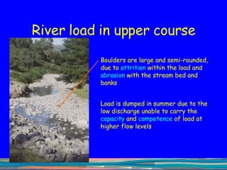
- 19. River load in upper course Boulders are large and semi-rounded, due to attrition within the load and abrasion with the stream bed and banks Load is dumped in summer due to the low discharge unable to carry the capacity and competence of load at higher flow levels
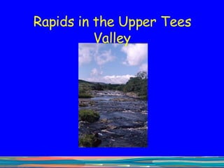
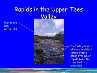
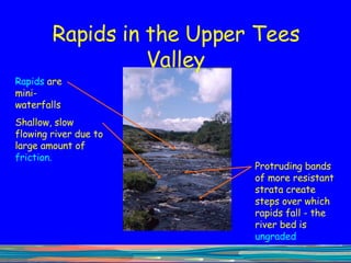
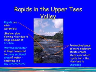
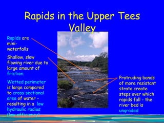
- 20. Rapids in the Upper Tees Valley
- 21. Rapids in the Upper Tees Valley Rapids are mini-waterfalls Protruding bands of more resistant strata create steps over which rapids fall - the river bed is ungraded
- 22. Rapids in the Upper Tees Valley Rapids are mini-waterfalls Protruding bands of more resistant strata create steps over which rapids fall - the river bed is ungraded Shallow, slow flowing river due to large amount of friction.
- 23. Rapids in the Upper Tees Valley Rapids are mini-waterfalls Protruding bands of more resistant strata create steps over which rapids fall - the river bed is ungraded Shallow, slow flowing river due to large amount of friction. Wetted perimeter is large compared to cross sectional area of water - resulting in a low ????????????
- 24. Rapids in the Upper Tees Valley Rapids are mini-waterfalls Protruding bands of more resistant strata create steps over which rapids fall - the river bed is ungraded Shallow, slow flowing river due to large amount of friction. Wetted perimeter is large compared to cross sectional area of water - resulting in a low hydraulic radius (low efficiency)
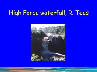
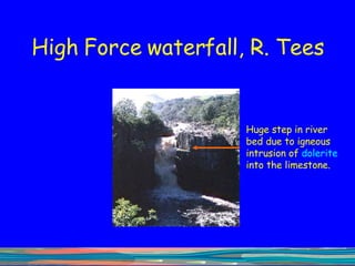
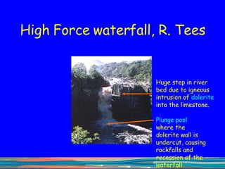
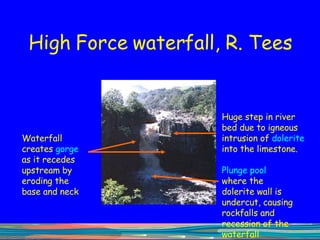
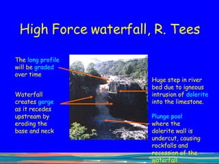
- 25. High Force waterfall, R. Tees
- 26. High Force waterfall, R. Tees Huge step in river bed due to igneous intrusion of dolerite into the limestone.
- 27. High Force waterfall, R. Tees Huge step in river bed due to igneous intrusion of dolerite into the limestone. Plunge pool where the dolerite wall is undercut, causing rockfalls and recession of the waterfall upstream
- 28. High Force waterfall, R. Tees Huge step in river bed due to igneous intrusion of dolerite into the limestone. Waterfall creates gorge as it recedes upstream by eroding the base and neck Plunge pool where the dolerite wall is undercut, causing rockfalls and recession of the waterfall upstream
- 29. High Force waterfall, R. Tees Huge step in river bed due to igneous intrusion of dolerite into the limestone. The long profile will be graded over time Waterfall creates gorge as it recedes upstream by eroding the base and neck Plunge pool where the dolerite wall is undercut, causing rockfalls and recession of the waterfall upstream
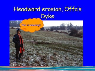
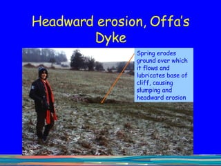
- 30. Headward erosion, Offa’s Dyke This is amazing!!
- 31. Headward erosion, Offa’s Dyke Spring erodes ground over which it flows and lubricates base of cliff, causing slumping and headward erosion
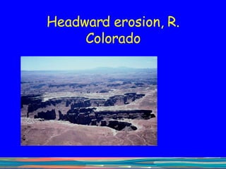
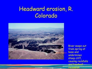
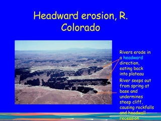
- 32. Headward erosion, R. Colorado
- 33. Headward erosion, R. Colorado River seeps out from spring at base and undermines steep cliff, causing rockfalls and headwall recession
- 34. Headward erosion, R. Colorado Rivers erode in a headward direction, eating back into plateau River seeps out from spring at base and undermines steep cliff, causing rockfalls and headwall recession
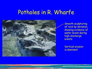
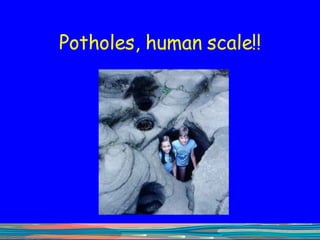
- 35. Potholes in R. Wharfe Smooth sculpturing of rock by abrasion, showing evidence of water levels during high discharge events Vertical erosion is dominant
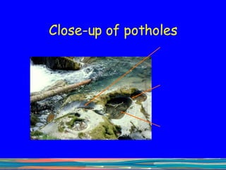
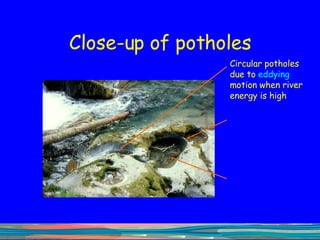
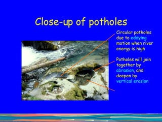
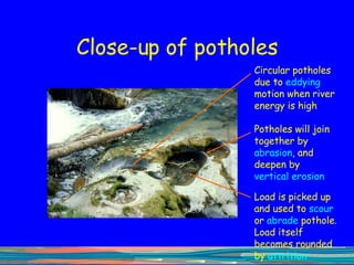
- 38. Close-up of potholes Circular potholes due to eddying motion when river energy is high
- 39. Close-up of potholes Circular potholes due to eddying motion when river energy is high Potholes will join together by abrasion , and deepen by vertical erosion
- 40. Close-up of potholes Circular potholes due to eddying motion when river energy is high Load is picked up and used to scour or abrade pothole. Load itself becomes rounded by attrition Potholes will join together by abrasion , and deepen by vertical erosion
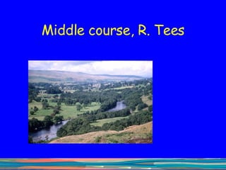
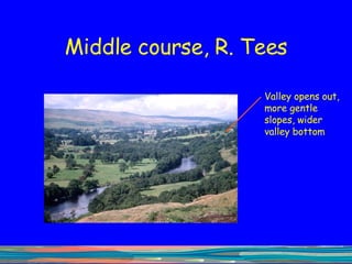
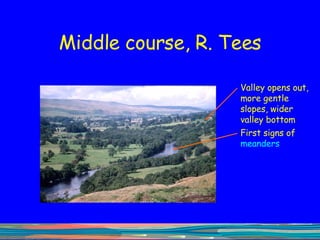
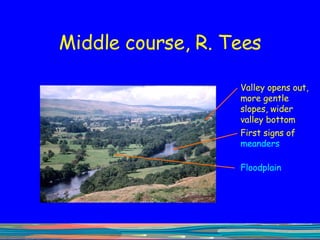
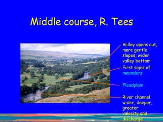
- 42. Middle course, R. Tees
- 43. Middle course, R. Tees Valley opens out, more gentle slopes, wider valley bottom
- 44. Middle course, R. Tees Valley opens out, more gentle slopes, wider valley bottom First signs of meanders
- 45. Middle course, R. Tees Valley opens out, more gentle slopes, wider valley bottom First signs of meanders Floodplain
- 46. Middle course, R. Tees Valley opens out, more gentle slopes, wider valley bottom First signs of meanders Floodplain River channel wider, deeper, greater velocity and discharge
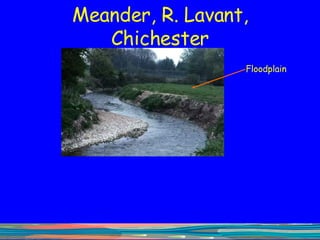
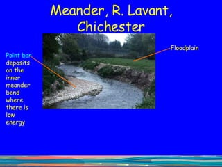
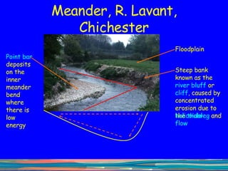
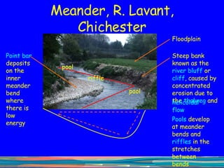
- 47. Meander, R. Lavant, Chichester
- 48. Meander, R. Lavant, Chichester Floodplain
- 49. Meander, R. Lavant, Chichester Floodplain Point bar deposits on the inner meander bend where there is low energy
- 50. Meander, R. Lavant, Chichester Floodplain Steep bank known as the river bluff or cliff , caused by concentrated erosion due to the Point bar deposits on the inner meander bend where there is low energy
- 51. Meander, R. Lavant, Chichester Floodplain Steep bank known as the river bluff or cliff , caused by concentrated erosion due to the thalweg Point bar deposits on the inner meander bend where there is low energy
- 52. Meander, R. Lavant, Chichester Floodplain Steep bank known as the river bluff or cliff , caused by concentrated erosion due to the thalweg and Point bar deposits on the inner meander bend where there is low energy helicoidal flow
- 53. Meander, R. Lavant, Chichester Floodplain Steep bank known as the river bluff or cliff , caused by concentrated erosion due to the thalweg and Point bar deposits on the inner meander bend where there is low energy helicoidal flow pool riffle pool Pools develop at meander bends and riffles in the stretches between bends
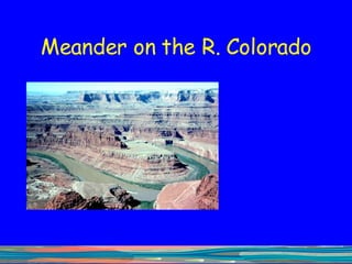
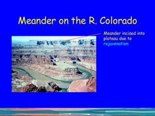
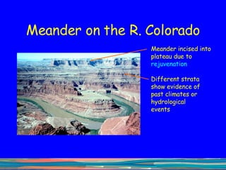
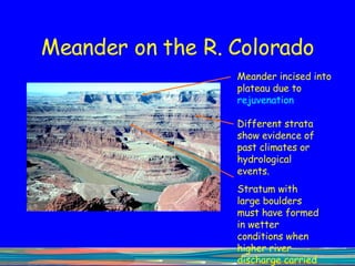
- 54. Meander on the R. Colorado
- 55. Meander on the R. Colorado Meander incised into plateau due to rejuvenation
- 56. Meander on the R. Colorado Meander incised into plateau due to rejuvenation Different strata show evidence of past climates or hydrological events
- 57. Meander on the R. Colorado Meander incised into plateau due to rejuvenation Different strata show evidence of past climates or hydrological events. Stratum with large boulders must have formed in wetter conditions when higher river discharge carried a greater competence of load
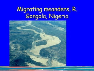
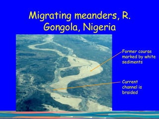
- 58. Migrating meanders, R. Gongola, Nigeria
- 59. Migrating meanders, R. Gongola, Nigeria Former course marked by white sediments Current channel is braided
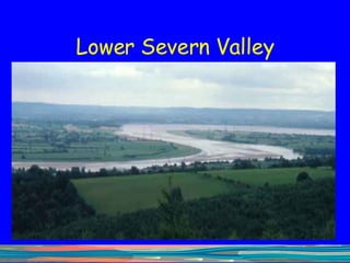
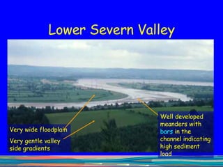
- 61. Lower Severn Valley Well developed meanders with bars in the channel indicating high sediment load Very wide floodplain Very gentle valley side gradients
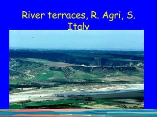
- 62. River terraces, R. Agri, S. Italy
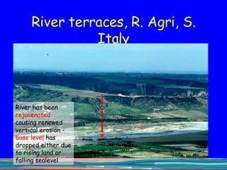
- 63. River terraces, R. Agri, S. Italy River has been rejuvenated causing renewed vertical erosion - base level has dropped either due to rising land or falling sealevel
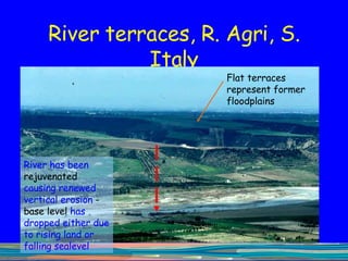
- 64. River terraces, R. Agri, S. Italy Flat terraces represent former floodplains River has been rejuvenated causing renewed vertical erosion - base level has dropped either due to rising land or falling sealevel
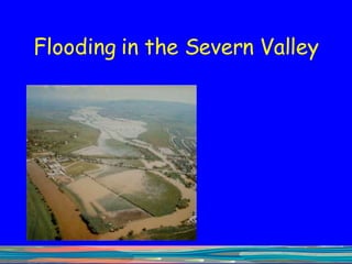
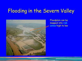
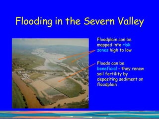
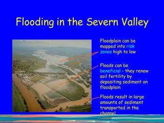
- 65. Flooding in the Severn Valley
- 66. Flooding in the Severn Valley Floodplain can be mapped into risk zones high to low
- 67. Flooding in the Severn Valley Floodplain can be mapped into risk zones high to low Floods can be beneficial - they renew soil fertility by depositing sediment on floodplain
- 68. Flooding in the Severn Valley Floodplain can be mapped into risk zones high to low Floods can be beneficial - they renew soil fertility by depositing sediment on floodplain Floods result in large amounts of sediment transported in the channel
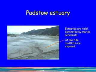
- 69. Padstow estuary Estuaries are tidal, dominated by marine sediments At low tide, mudflats are exposed
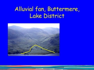
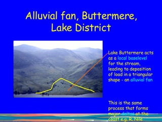
- 70. Alluvial fan, Buttermere, Lake District
- 71. Alluvial fan, Buttermere, Lake District
- 72. Alluvial fan, Buttermere, Lake District Lake Buttermere acts as a local baselevel for the stream, leading to deposition of load in a triangular shape - an alluvial fan This is the same process that forms major deltas at the coast e.g. R. Nile
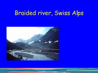
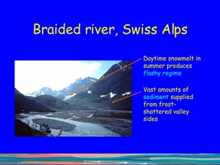
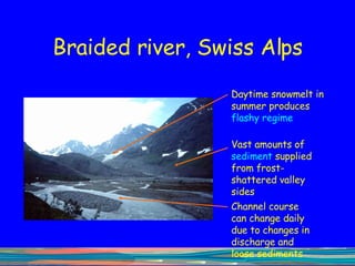
- 73. Braided river, Swiss Alps
- 74. Braided river, Swiss Alps
- 75. Braided river, Swiss Alps Daytime snowmelt in summer produces flashy regime Vast amounts of sediment supplied from frost-shattered valley sides
- 76. Braided river, Swiss Alps Daytime snowmelt in summer produces flashy regime Vast amounts of sediment supplied from frost-shattered valley sides Channel course can change daily due to changes in discharge and loose sediments
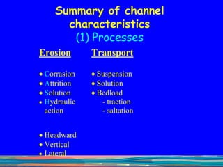
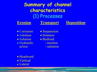
- 77. Summary of channel characteristics (1) Processes
- 78. Summary of channel characteristics (1) Processes
- 79. Summary of channel characteristics (1) Processes
- 80. Summary of channel characteristics (1) Processes
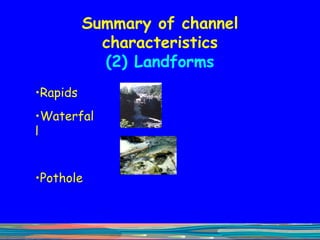
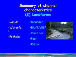
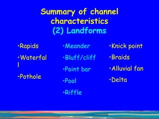
- 81. Summary of channel characteristics (2) Landforms
- 82. Summary of channel characteristics (2) Landforms Rapids Waterfall Pothole
- 83. Summary of channel characteristics (2) Landforms Rapids Waterfall Pothole Meander Bluff/cliff Point bar Pool Riffle
- 84. Summary of channel characteristics (2) Landforms Rapids Waterfall Pothole Meander Bluff/cliff Point bar Pool Riffle Knick point Braids Alluvial fan Delta
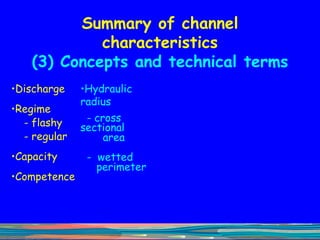
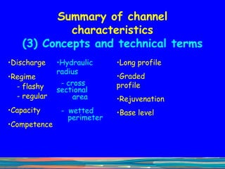
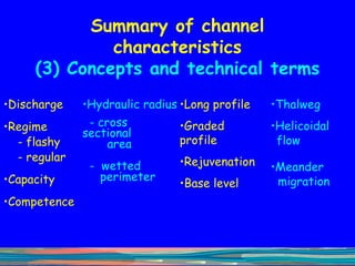
- 85. Summary of channel characteristics (3) Concepts and technical terms
- 86. Summary of channel characteristics (3) Concepts and technical terms Discharge Regime - flashy - regular Capacity Competence
- 87. Summary of channel characteristics (3) Concepts and technical terms Discharge Regime - flashy - regular Capacity Competence Hydraulic radius - cross sectional area - wetted perimeter
- 88. Summary of channel characteristics (3) Concepts and technical terms Discharge Regime - flashy - regular Capacity Competence Hydraulic radius - cross sectional area - wetted perimeter Long profile Graded profile Rejuvenation Base level
- 89. Summary of channel characteristics (3) Concepts and technical terms Discharge Regime - flashy - regular Capacity Competence Hydraulic radius - cross sectional area - wetted perimeter Long profile Graded profile Rejuvenation Base level Thalweg Helicoidal flow Meander migration
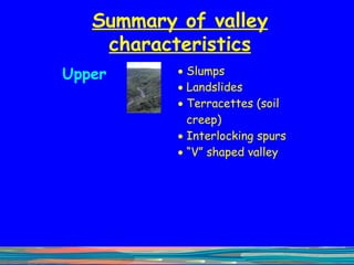
- 90. Summary of valley characteristics
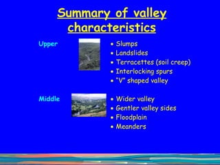
- 91. Summary of valley characteristics
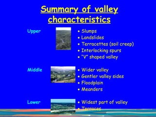
- 92. Summary of valley characteristics
- 93. Summary of valley characteristics