Rivers Year 11
- 1. Understanding GCSE Geography - Chapter 3, River Processes and Features King Edward VI Camp Hill School for Boys
- 2. - Rivers begin in upland areas and flow downhill. The point at which the river starts is called the source . - On the river's course other smaller rivers called tributaries join with the main river. The joining points are called confluences . - The water in rivers and tributaries is obtained by the surrounding land. This area is called the drainage basin . The boundary of this area is the watershed . - This is part of the Hydrological Cycle .
- 5. - A river flows within a channel . These channels become wider as the river flows downstream. - The shape of the channel changes as the river flows downstream. - This is mainly due to the potential energy of the river causing hydraulic action . Extra energy is used to erode sideways as the river is wider because it is closer to its base level. - The long profile of a river is steep and concave . The changes in the river and it's features allow us to sub-divide the river into three sections.
- 7. pg 33
- 8. Upper Course of a River
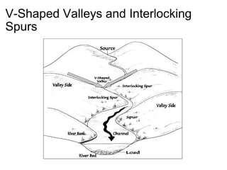
- 9. V-Shaped Valleys and Interlocking Spurs
- 10. Interlocking Spurs formed when rivers wind their way around hard rock. valley gradient is steep are not to be confused with meanders
- 11. Interlocking spurs at Ashes Hollow, tributary to the River Severn
- 12. V-Shaped River valleys caused by vertical erosions in river valleys erosion can be caused by hydraulic power, corrosion, abrasion and attrition steep-sided and narrow soil and loose rock moved downhill by soil creep or slopwash
- 13. Cwm Doethie 5km from Ystradffin , Carmarthenshire/Sir Gaerfyrddin, Great Britain
- 14. The River Channel narrow and shallow often lined with angular boulders gradient may be steep high velocity
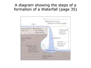
- 15. A diagram showing the steps of a formation of a Waterfall (page 35)
- 16. Iguaza Falls Panorama of the Argentina side of the falls from Brazil
- 17. A diagram showing the formation of a Gorge (page 35)
- 18. The Middle course of a river
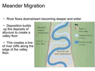
- 19. Meanders Meanders are bends in the river`s course Force of water erodes and undercuts the outside bend by corrasion, forming a river cliff. Sand and small pebbles are deposited creating slip-off slope Lateral erosion on the outside bend of the meander widens valley floor
- 20. Meander Migration River flows downstream becoming deeper and wider Deposition builds up the deposits of alluvium to create a valley floor This creates a line of river cliffs along the edge of the valley floor.
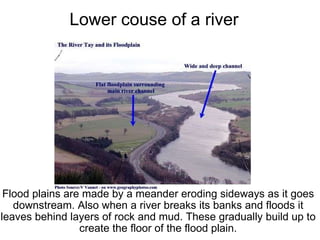
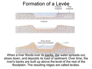
- 22. Lower couse of a river Flood plains are made by a meander eroding sideways as it goes downstream. Also when a river breaks its banks and floods it leaves behind layers of rock and mud. These gradually build up to create the floor of the flood plain.
- 23. When a river floods over its banks, the water spreads out, slows down, and deposits its load of sediment. Over time, the river's banks are built up above the level of the rest of the floodplain. The resulting ridges are called levées. Formation of a Levée
- 24. The Rhone Delta
- 25. Southern France. WHERE IS IT?
- 26. WHAT IS IT? The Rhone Delta is an area of land where the Rhone flows into the Mediterranean. Anyway, once the Rhone escapes France, it surrenders all the sediment that it has picked up. Having surrendered, the river leaves behind all this sediment in a triangular formation, which gives rise to the name. The Camargue, as it's known by our continental friends, is home to a vast array of wildlife. Also, the étangs are a distinct feature.
- 27. HOW ABOUT NOW? Nowadays , the Rhone Delta provides various opportunities for human involvement: Farmers! Tourists! Civil Engineers! Salt lovers! Wildlife Conservationists! Geography Textbooks! Cyclists! Seagulls!
- 28. The Uplands of the river Tees. The River Tees' source is on Cross Fell in the Pennines, where rainfall is around 2000mm a year, and run-off is high, due to steep slopes and impermeable rock. The High Force is a large waterfall along the route of the River Tees, one of the largest in Britain. It has a cap rock made of Whinstone, an igneous rock that is highly resistant to erosion. The rock beneath the cap rock is sandstone and so is eroded a lot by the running water, leaving a large overhang. The waterfall receding upriver has left a large gorge of recession, a steep sided valley caused by waterfall retreat.
- 29. Industry use in the River Tees Pastoral Agriculture Used for grazing for sheep in upper areas where soil is inadequate. Above 400m is free roaming herds while below 400m is dry-stoned walled fields and occasional herds of dairy cattle and hay or barley Tourism Open moorland, nature walks and market towns all lead to visitors coming to Upper Teesdale Brings employment and revenue to the area but also causes litter, congestion and damage to natural environments Large scale industry Used to have may lead mines which now act as attractions. An international pharmacutical company, forestry employments and craft/textiles outlets act as employers. Additionally quarrying of Whinstone due to its great resistance.
- 31. Other land uses in the River Tees Water supply and storage Extremely high quality of water so the land is used for a water suppy to local homes. The reservoirs used for water storage help to control the river even when flooding as the River Tees is notorious for flash floods Settlements and communications The difficult conditions and harsh landscape of the valley make it difficult for communications, and therefore has a knock on effect on employment. This means the population density is very low. Small farms and hamlets make up the majority of settlement sites.
- 32. As the valley widens downstream, the river starts to meander, as seen above. As it comes to the estuary, wide mud flats form, that are important wildlife areas for migratory birds and seals. p42
- 33. The lower course of the river tends to be much more urbanised. Factories and towns form in the lower plains near the estuaries, from which arises the need for management, due to flooding. Reservoirs are made. Light green = 0 - 60 metres Green = 61 - 120 metres Yellow = 121 - 300 metres Light Brown = 301 - 600 metres Brown = over 600 metres p42
- 34. The Tees Barrage P.43
- 35. What and Why? A barrage completed in 1995, which keeps the water between Yarm and Stockton consistantly at a high tide. Cost £54 million. The water is fresher and cleaner. It reduces the risk of flooding after high tides or storms. Has caused large-scale investment in the area due to the increased safety of surrounding land from flooding.
- 36. Decreasing Flood Risk Dredging This maintains a deep water channel, reducing flood risk. Sediment is dug from the bottom of the river, increasing the depth. Cutting of Meanders In 1810, a large meander was cut at the Mandale Loop, straightening the river and shortening it by 4km. The water moves faster along the channel, reducing flood risk.
- 37. Yarm's Flood Defences Reinforced concrete walls. Earth Embankments. Gabions. As well as creating these defences the planners used aesthetically pleasing enhancements such as landscaped gardening as well as leisure facilities such as fishing platforms.
- 38. Other Examples of Flood Defence The Yangtze River - China Frequent repairing and improving existing levees. Diverting water into a large nearby lake - Lake Dongting Creating flood diversion areas. These are generally in rural areas, although many people still live there, making the idea controversial. The Three Gorges Dam , which will store huge volumes of water.
- 39. River Regimes Velocity of a river is the speed of it, and is measured in meters per second. Volume of a river is the amount of water measured in square meters. Discharge is the amount of water passing through a given point in a set amount of time It is calculated by multiplying the velocity and volume for the river.
- 40. Graphs to show the differences in discharges in different regions
- 41. Flooding Flooding occurs in the lower course of the river and occur because: long periods of rainfall a cloudburst in a thunderstorm, causing a large amount of run off a sudden increase in temperatures, causing ice and snow to melt. During a rain storm, the discharge increases. The discharge of the river can cause it to be flood prone.
- 42. Flood Management Schemes
- 43. Hydrograph
- 44. The Mississippi river floods of 1993 (pg.46) Why did the floods form? During the spring snow melted This followed by 50 days of heavy rain
- 46. Results of the flood 28 Lives lost. 36,000 homes were lost. 6,000,000 acres of farmland were flooded. Millions of tonnes of silt and sand were deposited. An estimated US $10,000,000,000,000 0 were required to repair flood damage.
- 47. Flood Protection pg 47
- 48. Flood Protection US Corps of Engineers try to reduce flood risk, to prevent damage to land and property. Levées have been strengthened and raised, excavated cut-offs which straightens meanders, revetments built and river bed dredged. The levées were meant to prevent flood water from spilling onto land as they were built up material on either side of river valley increasing height river must raise to flood it’s bank. In 1993 for e.g., in Mississippi, floods were so high that they rose over levées and boulders were piled on top of them in some areas to help. Sandbags are used to help protect houses, for e.g., in Sainte Genevieve, 750,000 sandbags were used.
- 49. Flood Protection Controversy After floods, some questioned flood protection schemes. Argued that if water is gradually allowed to flood as it rises, it would cause less damage then when levées are used to contain a great amount of water meaning that when floods finally break these barriers, more damage is caused. Some say that flood plains will absorb the floods which are allowed to spill over gradually, and then the water will flow back into channel when the floods recede. Therefore, some argue that flood plains should be left untouched so it can absorb water as it is permeable, instead of inhabiting this area with tarmac and concrete which is impermeable so the floods cannot be absorbed.
- 51. Summary How does a river change as it flows downstream? We will look at 3 stages: Upper course Middle course Lower course
- 52. Upper course of the river. Shape of the valley: V-shaped with inter-locking spurs and a steep gradient. Processes at work: Mainly vertical erosion, cutting downwards. Features of the river: Narrow and turbulent river which is often clear with pools, potholes and boulders in river bed. Human land uses: Dams for water supply and tourism, rough grazing for sheep farming and some coniferous plantations.
- 53. Middle course of the river. Shape of the valley: A more open U-shape with a flatter valley floor and sloping valley sides. Processes at work: Sideways erosion widening the valley with still some vertical erosion. Features of the river: The river begins to meander and the river channel as broader and flatter. Human land uses: Smaller fields for crops and animals and occasionally market towns and villages.
- 54. Lower course of the river. Shape of the valley: The valley is now wide and flat - the flood plain emerges with levees and meander scars. Processes at work: Some erosion on outside bends of meanders but little vertical erosion. Deposition increases on the river bed and on the flood plain during floods. Features of the river: Meanders may become cut off to form ox-bow lakes and levees may form. At the mouth of the river a delta is a possibility or mud flats in estuaries. Human land uses: Flat flood plains provide ideal sites for farming, towns, cities and ports. The land uses are urban as the sea is closer.
Editor's Notes
- page 34
- page 34
- page 34
- page 34
- page 34
- Page 34
- Page 34
- PAGE 40 :)
