Sataf
Village in Jerusalem, Mandatory Palestine From Wikipedia, the free encyclopedia
Sataf (Arabic: صطاف, Hebrew: סטף) was a Palestinian village in the Jerusalem Subdistrict depopulated during the 1948 Arab–Israeli War. It was located 10 km west of Jerusalem, with Sorek Valley (Arabic: Wadi as-Sarar) bordering to the east.
Sataf
صطاف | |
|---|---|
Village | |
 Remains of Sataf village | |
| Etymology: from a personal name[1] | |
.jpg) 1870s map 1870s map .jpg) 1940s map 1940s map.jpg) modern map modern map .jpg) 1940s with modern overlay map 1940s with modern overlay mapA series of historical maps of the area around Sataf (click the buttons) | |
 Sataf Location within Mandatory Palestine | |
| Coordinates: 31°46′9″N 35°7′38″E | |
| Palestine grid | 162/130 |
| Geopolitical entity | Mandatory Palestine |
| Subdistrict | Jerusalem |
| Date of depopulation | July 13–14, 1948[2] |
| Area | |
• Total | 3,775 dunams (3.775 km2 or 1.458 sq mi) |
| Population (1945) | |
• Total | 540[4][3] |
| Cause(s) of depopulation | Military assault by Yishuv forces |
Two springs, Ein Sataf and Ein Bikura flow from the site into the riverbed below.
A monastery located across the valley from Sataf, i.e. south of Wadi as-Sarar, known by local Arabs as Ein el-Habis (the "Spring of the Hermitage"), is officially called Monastery of Saint John in the Wilderness.
Today it is a tourist site showcasing ancient agricultural techniques used in the Jerusalem Mountains.
History
Summarize
Perspective
Chalcolithic period
Remains of a 4,000 BCE Chalcolithic village were discovered at the site. The related traces of agricultural activities number among the oldest in the region.[5]
Byzantine period
Most ancient remains date to the Byzantine period.[5]
Mamluk period
The first written mention of the site is from the Mamluk era.[5]
Ottoman period
Sataf was noted in the Ottoman tax records of 1525-1526 and 1538–1539, as being located in the Sanjak of Al-Quds.[6] According to archaeological work, the village originated in the late 16th century, with the use of several cave−dwellings. Later, houses were erected in front of the caves.[7]
In 1838 it was described as a Muslim village, located in the Beni Hasan district, west of Jerusalem.[8]
In 1863, Victor Guérin found a village of one hundred and eighty people. He further noted that their houses were standing on the slopes of a mountain, and that the mountainside was covered by successive terraces.[9] An Ottoman village list from about 1870 counted 38 houses and a population of 115, whereby only men were counted.[10][11]
In 1883, the Palestine Exploration Fund's Survey of Western Palestine described Setaf as "a village of moderate size, of stone houses, perched on the steep side of a valley. It has a spring lower down, on the north."[12]
In 1896 the population of Sataf was estimated to be about 180 persons.[13]
British Mandate period
By the 1922 census of Palestine conducted by the British Mandate authorities, Sataf had a population of 329; 321 Muslims and 8 Christians.[14] All the Christians were Roman Catholic.[15] The 1931 census lists 381 inhabitants; 379 Muslim and 2 Christian, in a total of 101 houses.[16]
In the 1945 statistics the population of Sataf was 540, all Muslims,[4] and the total land area was 3,775 dunams, according to an official land and population survey.[3] Of this, 928 dunams were plantations and irrigable land, 465 for cereals,[17] while 22 dunams were built-up land.[18]
1948, aftermath
On July 13–14, 1948 the Arab village was depopulated by the Har'el Brigade, during Operation Danny.[19] Sataf and the surrounding area became part of the newly created State of Israel.
A short time after the 1948 War, a small group of Jewish immigrants from North Africa settled for a few months in the village area, calling it Bikura.[20] The village, which lasted only until the fall of 1950, was founded on the initiative of former Lehi commanded Natan Yellin-Mor.[20] Subsequently, the IDF's Unit 101 and paratroopers used the site for training purposes.[5]
In the 1980s the Jewish National Fund began the restoration of ancient agricultural terraces, and the area around the springs has been turned into a tourist site. A forest around the site was also planted by the Jewish National Fund.[21]
In 1992, Sataf was described as follows: "Many half-destroyed walls still stand, and some still have arched doorways. The walls of a few houses with collapsed roofs are almost intact....The area around the village spring, which is located to the east next to the ruins of a rectangular stone house, has been turned into an Israeli tourist site. A Jewish family has settled on the west side of the village, and have fenced in some of the village area."[19]
Shrine of 'Ubayd
The shrine (maqam) of 'Ubayd, southwest of the village site, contains a courtyard and three rooms.[7] According to Tawfiq Canaan, Sheikh 'Ubayd "is said to kill any goat or sheep who enters his cave."[22]
Gallery
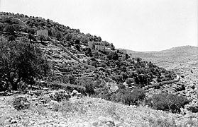 The hill (jabal) across from Sataf. September 1, 1945.
 Ein Sataf (Ein El-Balad), 2022
 Ein Sataf, 2009
 Ein Bikura (Ein E-Sharkia), 2022
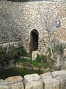 Ein Bikura, 2009
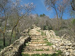 Sataf reconstruction
 Agriculture in Sataf, 2009
 Remains of Sataf village


References
Bibliography
External links
Wikiwand - on
Seamless Wikipedia browsing. On steroids.