Category:Maps-for-free images
Jump to navigation
Jump to search
English: Some maps from www.maps-for-free.com are freely licensed, see About (License and Copyright). Please note the following:
- Only Relief Maps and all Map Layers (except the labeling layer and contour layer) are free, the other views are copyrighted.
- The free license on maps-for-free.com was changed from CC-by-sa-3.0 to GFDL somewhen in spring 2008, cf. [1].
Subcategories
This category has the following 2 subcategories, out of 2 total.
Media in category "Maps-for-free images"
The following 185 files are in this category, out of 185 total.
-
 01-Figuès.png 1,688 × 1,540; 265 KB
-
 A topographic map of the Region of Ali Sabieh.png 931 × 816; 934 KB
-
 A topographic map of the Region of Arta.png 1,461 × 688; 1,006 KB
-
 A topographic map of the Region of Dikhil.png 1,401 × 1,573; 2.65 MB
-
 Adour basin.png 395 × 401; 326 KB
-
 Bahnstrecke Jaffa-Jerusalem.jpg 800 × 767; 424 KB
-
 Basque Mountains Topographic Map.png 760 × 543; 790 KB
-
 Battle of Actium-he.jpg 2,000 × 1,489; 942 KB
-
 Belgium relief.png 3,072 × 2,560; 3.52 MB
-
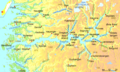
 Bergen Hardangerfjord.png 511 × 506; 97 KB
-
 Bergen Stavanger Fjorde.png 511 × 787; 140 KB
-
 Bitwy Rugia 1168, Darß 1184.png 1,409 × 908; 218 KB
-
 Bristol Bay.png 625 × 472; 389 KB
-
 Carta geografica fisica America nord e sud.png 542 × 677; 158 KB
-
 Carte topographique du Massif Central.png 422 × 540; 506 KB
-
 Central Serbia relief map.png 745 × 792; 1.49 MB
-
 Chamagudao (no names).png 1,183 × 869; 1.77 MB
-
 Chamagudao.png 1,183 × 869; 1.74 MB
-
 Châteaux de la Loire - Karte.jpg 4,057 × 1,545; 5.23 MB
-
 CO-Pipeline.png 931 × 1,065; 1.05 MB
-
 Darß bitwa 1184.png 1,409 × 908; 219 KB
-
 De-wittlicher-senke.png 475 × 415; 438 KB
-
 Doerenther Klippen im Osning.png 974 × 649; 719 KB
-
 Donautalbahn Karte.jpg 1,500 × 841; 801 KB
-
 Drehstromuebertragung Lauffen-Frankfurt.png 615 × 1,332; 1.31 MB
-
 Elm-Asse-Karte.png 739 × 591; 364 KB
-
 Europa Fisica e confine Europa Asia.png 1,316 × 846; 522 KB
-
 Fallstein-Huy-Karte.png 908 × 715; 527 KB
-
 Fleurieu Group, Tasmania, Relief.jpg 731 × 794; 53 KB
-
 Flusssystemkarte Rhein 02.jpg 3,197 × 4,342; 11.75 MB
-
 Flusssystemkarte Rhein 03.jpg 3,198 × 4,342; 11.75 MB
-
 Flusssystemkarte Rhein 04.jpg 3,198 × 4,344; 11.72 MB
-
 Flusssystemkarte Rhein 05.jpg 3,199 × 4,341; 12.35 MB
-
 Flusssystemkarte Rhein 06.jpg 3,198 × 4,343; 11.74 MB
-
 France atlantic coast with large South West highlighted.png 301 × 381; 178 KB
-
 France Golfe du Lion with Large South-West highlighted.png 683 × 548; 568 KB
-
 Frankreich Relief.png 685 × 660; 837 KB
-
 Førdefjord.png 937 × 449; 109 KB
-
 Garonne Adour 2.png 586 × 554; 676 KB
-
 Gascogne.png 248 × 181; 110 KB
-
 Geografia Fisica Oceania.jpg 969 × 641; 79 KB
-
 Golfe du Lion.png 683 × 548; 529 KB
-
 Hamadan Topography.PNG 458 × 475; 419 KB
-
 Hessen phys Karte.gif 566 × 692; 310 KB
-
 Hong River and Tributaries.png 689 × 636; 1.11 MB
-
 Infotafel Reitergrab Hankenbostel-20240228.jpg 4,402 × 2,904; 16.72 MB
-
 Iruñeko faila.png 1,244 × 1,288; 3.96 MB
-
 Italy Topography Map.jpg 2,456 × 3,508; 1.84 MB
-
 Ith-Hils-Karte.png 840 × 800; 882 KB
-
 Jastrebac relief.png 675 × 479; 839 KB
-
 Jintang island.png 319 × 348; 112 KB
-
 Jylland Fjorder SH Förden.png 816 × 2,524; 202 KB
-
 Jylland Fyn Schleswig Holstein basis.png 1,300 × 2,963; 290 KB
-
 Kalmius river map hu.svg 448 × 611; 540 KB
-
 Karibik 21.png 1,332 × 794; 496 KB
-
 Karibik 27.png 1,350 × 781; 767 KB
-
 Karte Gemeinde Vintl.png 1,085 × 1,463; 1.72 MB
-
 Karte Hilsmulde A - Sackmulde B.png 530 × 531; 629 KB
-
 Karte Kleinwalsertal SRTM3.png 1,000 × 959; 1.23 MB
-
 Karte Lueneburger Heide.png 1,089 × 1,007; 1.34 MB
-
 Karte Mount Everest - Route Hillary und Norgay.png 1,000 × 931; 873 KB
-
 Karte Mount Everest.png 1,000 × 1,000; 1.1 MB
-
 Karte Neckar-Enz-Stellung.png 1,000 × 2,000; 3.02 MB
-
 Karte Rheinhessischer Jakobsweg.png 1,047 × 1,200; 1.5 MB
-
 Karte Uebersicht Vintl.png 1,534 × 1,417; 2.99 MB
-
 Kish map.png 946 × 677; 139 KB
-
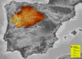
 La Safor within Spain.PNG 904 × 413; 281 KB
-
 Leipzig Lowlands.png 515 × 501; 330 KB
-
 Littoral atlantique français.png 301 × 381; 170 KB
-
 Locaation map Denmark Zealand.png 909 × 854; 699 KB
-
 Location map Canada Vancouver Downtown.png 1,116 × 828; 687 KB
-
 Location map Canada Vancouver Richmond.png 1,262 × 856; 812 KB
-
 Location map Canada Vancouver.png 1,265 × 852; 997 KB
-
 Location map Denmark Funen.png 1,227 × 859; 1.02 MB
-

-
 Map of Boknafjorden.PNG 412 × 383; 68 KB
-
 Map Rhine and catchment area deutsch.jpg 2,132 × 2,891; 2.86 MB
-
 Mapa Topográfico da Serra do Caparaó.png 353 × 519; 404 KB
-
 Mapa Topográfico da Serra dos Pacaás Novos.png 1,350 × 629; 2.04 MB
-
 Mapa Topográfico de Ilhabela, Ilha de Búzios e Ilha da Vitória.png 835 × 468; 418 KB
-
 Mapa Topográfico do Maciço de Baturité.png 747 × 761; 1.18 MB
-
 Maps-for-free Sierra Nevada.png 497 × 399; 377 KB
-
 Marianengraben.svg 250 × 300; 93 KB
-
 Mecklenburg-Vorpommern.gif 1,562 × 1,190; 360 KB
-
 Mittelsachsen.gif 439 × 350; 76 KB
-
 Mittelsachsen.png 438 × 314; 185 KB
-
 MountEverestRelief.png 1,280 × 620; 1.82 MB
-
 München Flughafen Lage.png 800 × 800; 411 KB
-
 Münchner Schotterebene.png 1,877 × 1,530; 825 KB
-
 Naturpark Südheide Radtouren.jpg 1,852 × 2,003; 2.95 MB
-
 Naturpark Südheide-Reittour (1).JPG 3,933 × 2,975; 8.98 MB
-
 Naurpark Südheide Karte@20210629.jpg 2,606 × 2,246; 5.46 MB
-
 Naxos Relief Maps for free.jpg 456 × 571; 202 KB
-
 Network Chemin de Fer Jonction Salonique–Constantinople.png 3,011 × 1,344; 4.46 MB
-
 Nordwestbulgarien.png 1,342 × 835; 2.01 MB
-
 Ostural-Spur.png 1,070 × 790; 1.38 MB
-
 Ostural-Spur.xcf 1,070 × 790; 2.7 MB
-
 P Luxembourg topo.jpg 692 × 558; 42 KB
-
 Peene & Trebel.png 689 × 737; 105 KB
-
 Peene.png 938 × 737; 135 KB
-
 Pelop roh.png 1,110 × 670; 1.44 MB
-
 Peloponnisos-b2.png 1,180 × 962; 1.51 MB
-
 Piémont pyrénéen.png 710 × 357; 624 KB
-
 Proposed Bhutan Rail Connections.png 1,605 × 1,028; 2.24 MB
-
 Précipitation dept56.png 616 × 505; 26 KB
-
 Pyrenees Relief France Large South-West highlighted.png 1,266 × 786; 2.1 MB
-
 Pyrenees Relief.png 1,266 × 786; 2.05 MB
-
 Radøy, Meland og Lindås.PNG 782 × 584; 938 KB
-
 Recknitz.png 1,413 × 2,238; 2.95 MB
-
 Relevo da Pedra da Mina.png 500 × 359; 571 KB
-
 Relief World Map by maps-for-free.jpg 16,384 × 12,544; 39.4 MB
-
 Reliefkarte Alfeld Umgebung.png 900 × 900; 1.6 MB
-
 Reliefkarte Homburg, Elfas, Holzberg, Amtsberge.png 527 × 344; 394 KB
-
 ReliefKilimanjaro.png 1,095 × 634; 972 KB
-
 Reliefmap of Australia.png 996 × 914; 1.18 MB
-
 Reserva de la biosfera intercontinental del Mediterráneo.svg 997 × 997; 3.1 MB
-
 Rheinhessen Relief Karte.png 1,031 × 1,183; 1.23 MB
-
 Rheinsystem blanco.jpg 3,196 × 4,342; 10.46 MB
-
 Rheinsystem small blanco.jpg 2,133 × 2,889; 2.19 MB
-
 Rheinsystem small DE Main.png 2,133 × 2,885; 9.82 MB
-
 Rheinsystem small deutsch.jpg 2,133 × 2,885; 2.8 MB
-
 Rheinsystem small english.jpg 2,133 × 2,888; 2.85 MB
-
 Rheinsystem small francais.jpg 2,133 × 2,888; 2.86 MB
-
 Rheinsystem small internat.jpg 2,133 × 2,890; 2.87 MB
-
 Rheinsystem small nederlands.jpg 2,133 × 2,885; 2.85 MB
-
 Rif mountains.png 766 × 479; 586 KB
-
 Rio Apurímac.png 872 × 970; 1.71 MB
-
 Rio Ene.png 894 × 1,122; 2.42 MB
-
 Rio Tambo.png 948 × 1,098; 2.28 MB
-
 Rivers of Madre de Dios.png 1,406 × 884; 2.24 MB
-
 Rivières gersoises.png 625 × 557; 629 KB
-
 Rl3c la laos map illdtmcolgw30s ja hres.jpg 2,444 × 3,508; 2.11 MB
-
 RSG SRTM raw.png 3,200 × 2,143; 10.99 MB
-
 Sachsen.gif 1,249 × 1,068; 657 KB
-
 Schleswig-Holstein.png 1,123 × 1,133; 165 KB
-
 Selztal-Radweg.png 436 × 664; 321 KB
-
 SH16+fl+gr.png 1,123 × 1,133; 126 KB
-
 Shudao ZH.png 845 × 881; 1.48 MB
-
 Shudao.png 845 × 881; 1.45 MB
-
 Sognefjord.png 1,246 × 746; 324 KB
-
 South Alpine lakes.png 1,240 × 765; 599 KB
-
 SpainDueroBasin.png 1,748 × 1,249; 2.55 MB
-
 SpanienDuero.jpg 1,316 × 940; 552 KB
-
 Tea-Horse-Road.png 1,183 × 869; 1.73 MB
-
 Tee-Pferde-Straße.png 1,183 × 869; 1.73 MB
-
 The geography of the Republic of Djibouti.png 2,815 × 3,023; 14.07 MB
-
 The Romantic Road in Germany (blank map).png 1,368 × 1,581; 2.24 MB
-
 Three-gorges-map.png 927 × 379; 967 KB
-
 Topographic Map of Bir Tawil.png 1,832 × 828; 2.21 MB
-
 Topographic map of Chimantá Massif.png 816 × 780; 1.29 MB
-
 Topographic map of Garonne and Adour.svg 642 × 627; 2.9 MB
-

-
 Topographic map of South-West France with main rivers and cities.svg 1,028 × 885; 2.9 MB
-
 Treno corridoio Lienz - Innsbruck.jpg 914 × 734; 612 KB
-
 Tsavo national park map en.png 1,000 × 967; 1.15 MB
-
 Tysnes.png 345 × 417; 266 KB
-
 Ucker–Uecker, Randow, Welse.png 480 × 752; 80 KB
-
 Verlaufskarte Ablach.png 800 × 624; 600 KB
-
 Verlaufskarte Brenzbahn.png 1,000 × 1,796; 2.05 MB
-
 Verlaufskarte der Romantischen Strasse.png 1,368 × 1,581; 2.33 MB
-
 Verlaufskarte Dreiseenbahn 2.png 1,000 × 904; 955 KB
-
 Verlaufskarte Enztalbahn.png 1,000 × 1,113; 1,014 KB
-
 Verlaufskarte Gäubahn (Stuttgart-Singen).png 1,200 × 2,248; 3.79 MB
-
 Verlaufskarte Gäubahn Eutingen im Gäu-Freundenstadt.png 1,200 × 718; 872 KB
-
 Verlaufskarte Hegau-Ablachtal-Bahn (Seehäsle).png 1,150 × 1,200; 1.72 MB
-
 Verlaufskarte Höllentalbahn 2.png 1,500 × 841; 1.71 MB
-
 Verlaufskarte Kinzigtalbahn.png 777 × 800; 1.04 MB
-
 Verlaufskarte Main.gif 1,500 × 806; 374 KB
-
 Verlaufskarte Murgtalbahn.png 1,265 × 1,500; 1.94 MB
-
 Verlaufskarte Nagoldtalbahn.png 839 × 1,500; 1.46 MB
-
 Verlaufskarte Ostrach.png 619 × 800; 662 KB
-
 Verlaufskarte Schlesische Gebirgsbahn.jpg 2,000 × 1,209; 1.71 MB
-
 Verlaufskarte Schwarzwaldbahn (Baden).png 1,036 × 1,200; 2.35 MB
-
 Verlaufskarte Selz.png 800 × 759; 786 KB
-
 Verlaufskarte Weschnitz Hintergrund-hell.jpg 1,037 × 696; 233 KB
-
 Verlaufskarte Weschnitz.png 1,000 × 608; 646 KB
-
 Vienna Basin physical.png 926 × 1,066; 1.81 MB
-
 Vorpommern physisch.png 951 × 1,051; 175 KB
-
 World Flag Map Version 2.1.png 4,500 × 2,234; 1.44 MB
-
 World Map blank.PNG 1,427 × 628; 30 KB
-
 Zhs München Flughafen Lage.png 800 × 800; 880 KB
-
 Zht München Flughafen Lage.png 800 × 800; 879 KB
-
 Zollernalbbahn Karte.png 1,158 × 1,200; 1.9 MB
-
 Ökopolis Tiberkul.png 1,200 × 803; 1.03 MB
-
 نهر ينسي.png 812 × 956; 1.3 MB


.png)


.JPG)


.png)

.png)


.png)


.png)