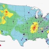
Huge swaths of the US, around three-quarters, could potentially experience a noteworthy earthquake within a hundred years, but the risk is not spread evenly. The scientists at the USGS have worked hard to develop a model, for the first time in history, that assesses the risk of each and every US state.
While they're careful to note that "no one can predict earthquakes," having a good understanding of your risk can help individuals, and our local institutions, plan for the future.
Of course, it's worth noting that small earthquakes happen regularly, and are largely meaningless for humans. As such, the minimum threshold used in this map for "potentially damaging earthquakes" is the intensity VI ("Strong") on the Modified Mercalli Intensity Scale. However, this includes the risk for even stronger quakes.
Key Findings:
-
Alaska, California and Hawaii all have a significant portion of their states with more than a 95 percent chance of a "Strong" earthquake.
-
Large portions of The Great Plains, The Midwest and The Southwest fit the lowest-risk category, with under a five percent chance.
-
While the majority of The East Coast fits in the 25 percent or less categories, portions of South Carolina, North Carolina, Virginia and New York have an increased risk in the 25 to 50 percent range.
Click the image to enlarge.
Looking to move to state with less earthquake risk? We hear that North Dakota is paying the big bucks for orthopedic surgeons.
Via USGS.

