blankblank blank


Archive for the 'GPX' Category

Free Marine Chart Views, Plus An Online Waypoint/Route Editor With GPS Export

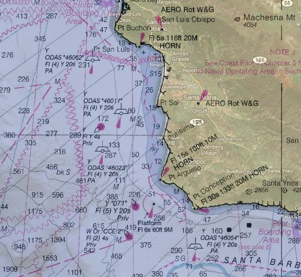
The Marine GeoGarage site offers free online views of marine charts from the following countries:

  • USA
  • Bahamas
  • Argentina
  • Brazil
  • Netherlands

A  10-euro monthly subscription (free 14-day trial) gets rid of the ads, and adds charts for the following countries:

  • UK and vicinity
  • Canada
  • Australia

Choose the country from the list at upper-right:

gg_1

The slider controls the transparency of the marine chart overlay in Google Maps; slide it all the way to the right, and the map disappears completely (more on this shortly). Map detail level scales with the zoom, so if you start zoomed out:

gg_2

And then zoom in :

gg_3

Map detail scales accordingly, if maps are available at different scales.

There are three checkboxes in the control section:

  • photos – shows geotagged panoramio photos. There’s usually so many of them near coastal areas that this feature is pretty useless.
  • fullscreen – Blows up the map interface to full size (but doesn’t get rid of ads in the free version).
  • coverage – Shows the coverage areas for all marine charts available at different scales, useful for seeing whether you can zoom in for more information:

coverage


There’s a scalebar at lower left, with the option to set the distance units used, and view the cursor coordinates (though the latter is a bit slow to update):

scalebar

So far, useful mainly for mariners. But the site also has editing tools that let you create GPS waypoints and routes; while these are useful for marine navigators, setting the map transparency to 100% lets you create terrestrial GPS waypoints and routes anywhere in the world. For example, by using the waypoints and routes toolbar:

tools

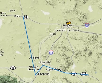
Plus setting the marine charts invisible, and setting Google Maps to Terrain view, I can create/edit waypoints and routes:
wr

And then export them to a GPX file for use on my GPS:

export

If you own a Garmin GPS unit, and you have the free Garmin Communicator plugin installed on your browser, you can even export the data directly from the website to a connected Garmin GPS.  Logging in with either free registration, OpenID, Google login, or other credentials, lets you save this data online for future editing and use.


Where’s The Path – UK OS Mapping Viewer And Tool

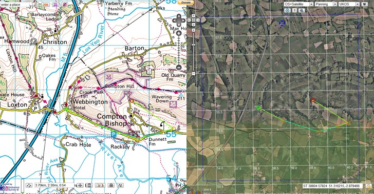
Where’s The Path lets you display UK Ordnance Survey 1:50K topographic maps side by side with other kinds of maps, including:

  • Google roads/satellite/terrain/hybrid
  • OpenStreetMap
  • 1930s and 1940s OS maps

Cursor movement on one map is mirrored in another; you can import  GPX/KML files, and also draw features on the map and export them to in GPX/KML format. Overlay multiple types of grids (lat/long and UKOS); toggle a Panoramio layer to see photos taken at locations within the map view:

wheresthepath

Most annoying aspect is that it’s only for the UK; wish someone could put something similar together for the US.

HT to Trev Broomfield.


Displaying GPS Data On A Website

Got an email a few weeks ago from someone who wanted to post data taken with a GPS, in GPX file format, and display it as an embeddable map on his blog; he couldn’t find anything on that on the web. I offered one possibility, and he in turn suggested that I might put up a brief post on the topic. Here’s a few ways to do it, off the top of my head.

Some of these will require you to convert your GPX data into an alternate format, like KML or shapefile. A search of this website will bring up lots of programs that can do these conversions, but probably the simplest way is to load your GPX file into Google Earth, then export the data in KML or KMZ format. Note: All of these sites require you to create a free account.

Google Maps My Maps – The alternative I suggested; not a lot of features, but very easy to use. Import KML/KMZ files from your computer or a web link, use the built-in editor to add additional features. You can then display the map on your website using a widget.

Google Docs Spreadsheet – If you convert your GPX files to CSV files using a program like DNRGarmin or GPXToPOI, you can import the data into a Google Docs spreadsheet; Google offers a tutorial on converting that data into a KML network link for display in Google Maps or the Google Earth plugin.

GeoCommons – Just posted about this yesterday; upload your data and display it in widget format. All data you upload will be available for anyone to use or download.

MapChannels – Lots of map creation features, and embeddable maps.

ScribbleMaps Pro – Similar to Google Maps My Maps, but offers lots more import options and drawing tools. Highly recommended.

Feel free to add your own recommendations in the comments section.


Distances And Calories Burned With The Gmaps Pedometer

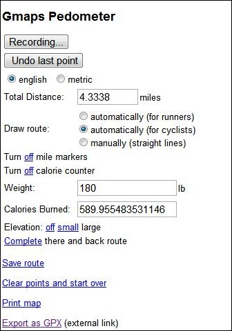
Another route-drawing app for Google Maps, but with some unusual features. The Gmaps Pedometer lets you create a route by clicking in a Google Maps interface, as do many other similar apps. Some of its features are:

  • The route can be straight lines between points, or be automatically routed for either running-friendly or cycling-friendly routes
  • Optional mile markers can be drawn along the route
  • Total route distance is calculated on the fly
  • You can display a graph of elevation change over the route
  • You can automatically do an out-and-back calculation for a return trip by the same route
  • Enter your weight and get an estimate of how many calories you’ll burn
  • Save the route as a permanent link
  • Print the map
  • Export the route to GPX (this is an external link to the GMapToGPX site)

Map/route and elevation display:

mapandelevationdisplay

Control panel and info readout:

cp

Tips:

  • Set all parameters (units, calorie counting, mile markers, etc.) before you start adding points; there doesn’t seem to be a way to change those after you’ve created the route and have those changes reflected in the map/display
  • Press the “Start Recording” button to start entering points, and double-click on the map to enter a point
  • If you want to export the route as a GPX, you should visit the GmapToGPX site first, and configure your browser as indicated to allow GPX export.
  • I modified the Gmaps Pedometer link slightly so that it would start out centered on the US; to customize it for your own center point, take the link URL (http://www.gmap-pedometer.com/?centerX=-90&centerY=35&zl=13&fl=m) and substitute your desired longitude for the centerX value, and latitude for the centerY.


Removing Time Data Out Of A GPX Or KML File To Make It Work Right In Google Earth

In the process of writing yesterday’s post on Garmin Basecamp, I found an annoying flaw on how Google Earth handles GPX files. In a recent GPS talk I gave, I surprised some people when I told them that Google Earth can open some GPS-related formats like GPX, LOC and others directly; you just need to select the type of files you want to open with the drop-down in the lower-right corner:

open_gpx

But if the waypoints in GPX files come time-stamped, either with the time you created them in the field or in a program, Google Earth assumes that you want to use this time-related data, and brings up a time slider in the upper-left-hand corner:

timeslider

The first time you open the file, the time slider will run from start to finish, with waypoints popping up and disappearing as the time indicator hits their creation time. You only see all the waypoints when the time slider has run all the way through to the end. Very annoying.

But it gets worse. If you uncheck the GPS data box in the Places pane to hide the data, then check it again, you’ll see nothing at all except the time slider:

timeslider1

Hitting the play button on the time slider will make the waypoints appear and disappear quickly, and at the end the only waypoint visible will be the last one created; the time slider will look like this:

timeslider2

To see all the waypoints, you’ll need to move the “start-time-extent” slider all the way to the left:

timeslider3

Same behavior if you save the data permanently to “My Places”. This is pretty retarded behavior; I hope Google adds the option to turn off time-related data display when it’s not wanted. Until then, I banged together a simple Windows-only program called GPXTimeStripper that will remove all time-related data from a GPX file (KML files, too, although this may not work in every case).  Download the file at this link; it’s a zipped stand-alone executable. Run the program (won’t win any interface awards):

Click on the main button, choose the GPX or KML file you want to process, and the program will remove the time data from the file, and save it with “_TS” appended to the filename. You’ll get a pop-up box with the name and location of the new file, which should always be the same location as the input file.  If the pop-up becomes annoying (which it will), check the box in the lower-left-hand corner to turn it off. Help button takes you to this page; Exit does what you’d expect.

No real checks for overwriting older files, and may not work on every file correctly (report bugs). Use at your own risk. BTW,  Google, would it kill you to have KML files created in Google Earth terminate in CR-LF instead of just LF?  It would simplify the job of reading them in correctly.


Garmin Basecamp Revisited

It’s been a bit more than a year since I first looked at Garmin’s free Basecamp software, and wasn’t terribly impressed. I did say, “Hopefully future versions will be snappier, and add more features.”  I just did a GPS presentation to a local hiking group, and in preparation for that took a full look at the latest version of Basecamp (3.05). In short, it’s a major improvement over the first release; it’s now better than Garmin’s classic MapSource program for uploading/downloading/managing data. It’s so improved that it wouldn’t be a bad basic choice for creating data for use with non-Garmin GPS models; just export the data to GPX format, then use a program like EasyGPS to send it to your model. As an added bonus, it’s available in both PC and Mac versions.

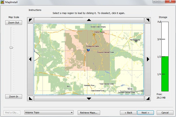
Probably the most important addition is an associated tool called MapInstall, that lets you upload Garmin-compatible maps to your GPS unit. Prior to this, the only complete tool for doing this was Garmin’s MapSource program, only available if you purchased a Garmin mapset, or Garmin’s Trip and Waypoint Planner software, sold for $30. If you wanted to use free mapsets like those available at the GPS File Depot, you were out of luck; now, you’re not. MapInstall isn’t as good for uploading and managing maps as MapSource, but it should be good enough for most people:

mapinstall

But there are lots of other useful new features:

  • Faster and less buggy than earlier versions
  • Tiled (poster) printing of installed mapsets
  • Support for Garmin Custom Maps and Birdseye Imagery
  • Better route management
  • Conversion of tracks to simplified routes
  • Better waypoint, track and route management
  • Better export to Google Earth
  • Ability to import mapsets pre-installed on some GPS models

Still some issues left, some kind of weird:

  • Import of KML files is iffy
  • Help file is still incomplete
  • Only supports USB-interface models; older serial models are out of luck (though you can still export data and use EasyGPS to upload it
  • There are features listed on the update/download page that don’t seem to exists, e.g. “Added printing of USGS Quads and other public land survey areas.”
  • Be nice to be able to simplify tracks and still keep them as tracks; now, you can only save a simplified route.
  • Basecamp insists on exporting waypoints to GPX, Google Earth format with a timestamp even if you’ve created them in the program (and don’t want a timestamp).

I did some Basecamp demo videos as a reference to what I presented at my talk, and have put them up on YouTube; not terribly exciting, but maybe you’ll find them useful.


Archive Of Old GPS Firmware And Software Updates

If you ever feel the need to roll your GPS back to an older version of the system firmware, you likely won’t find it on the manufacturer’s website; they typically only have the latest version. The Garmin Software Archives has a pretty extensive collection of  older firmware updates that covers most Garmin units released over the past dozen years, as well as some for other makers as well (Bushnell, deLorme and Magellan). The collection is most comprehensive for handheld units (need an update for your 12XL?), but includes some marine, aviation and automotive units as well. The archive also had older software updates for Garmin programs like MapSource, Basecamp, WebUpdater, POILoader , nRoute, even the old USB programmer for Garmin’s proprietary memory card format. Some programs (e.g. MapSource) don’t let you downgrade to an older version, so you’ll need to uninstall your current version, then install a valid older version from one of your map discs before using one of the updaters from the archive.

Almost forgot: there’s a link at the archive to a great Garmin PDF from 2005 on using your GPS with paper maps; also includes a page of map tools that you can print on a transparent sheet and use with USGS 1:24K topo maps (map grid for UTM and compass rose, and two scale rulers).


Draw GPX Data Directly On Web Maps Using The GPS Visualizer Freehand Drawing Tool

I’ve posted recently about ScribbleMaps and ScribbleMaps Pro, web apps that let you draw features on a number of web maps (like Google Maps, OSM, and ESRI), and export the data in GPX format for upload to a GPS. Stopped by the GPS Visualizer website the other day, and just noticed that they have a similar application now, the GPS Visualizer Freehand Drawing Tool. On the down side, it doesn’t have nearly as many tools, editing options and output options as ScribbleMaps; on the plus side, because it doesn’t have a large number of tools and options, it’s easy and intuitive to use. And in addition to Google Maps and OSM Maps, it offers a number of background map options that ScribbleMaps doesn’t:

Continue reading ‘Draw GPX Data Directly On Web Maps Using The GPS Visualizer Freehand Drawing Tool’