Public Tags
Showing images tagged with near:Red Moss tag.

|
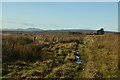
The Cumbria Way near Red Moss
by Adrian Taylor geograph for square SD2791 The Cumbria Way long distance footpath from Ulverston to Carlisle near Red Moss... (more)
Tags:
subject:BogX
Coniston Old ManX
CumbriaX
long distance footpath:Cumbria WayX
Cumbria WayX
ldp:Cumbria WayX
type:GeographX
top:Heath, ScrubX
top:Lakes, Wetland, BogX
top:PathsX
near:Red Moss
long distance footpath:The Cumbria WayX
The Cumbria WayX
ldp:The Cumbria WayX
long distance path:The Cumbria WayX
top:UplandsX
Westmorland and FurnessX
|

|
The Cumbria Way near Red Moss
by Adrian Taylor geograph for square SD2790 The Cumbria Way long distance footpath below the slopes of Beacon Fell near Red... (more)
Tags:
BogX
long distance path:Cumbria WayX
Cumbria WayX
ldp:Cumbria WayX
type:GeographX
top:Lakes, Wetland, BogX
subject:PathX
top:PathsX
near:Red Moss
top:Rocks, Scree, CliffsX
Stony PathX
long distance footpath:The Cumbria WayX
The Cumbria WayX
ldp:The Cumbria WayX
The Lake District National ParkX
top:UplandsX
|

|
The Cumbria Way above Red Moss
by Adrian Taylor geograph for square SD2790 The Cumbria Way follows a well-defined path north from Beacon Tarn, before... (more)
Tags:
BogX
BrackenX
Coniston Old ManX
ldp:Cumbria WayX
Cumbria WayX
type:GeographX
subject:PathX
top:PathsX
near:Red Moss
long distance footpath:The Cumbria WayX
The Cumbria WayX
ldp:The Cumbria WayX
long distance path:The Cumbria WayX
top:UplandsX
WetherlamX
|
|
Moorland Track at Roster, Caithness
by Andrew Tryon geograph for square ND2739 A seldom used and boggy moorland track at Roster in Caithness. On the horizon... (more)
|