Geograph - photograph every grid square
About tags on Geograph
Tags
Geographical Context
Subjects
Types
Other Prefixes
Public Tags
Related Tags
|
Coverage Map
Prefix:
place
Tag:
Midlands
Other tags:
Midlands
Showing images tagged with
place:
Midlands
tag.
View all tagged images
-
In Browser
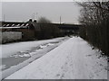
Snowy way to Fazeley - Aston, Birmingham
by
Martin Richard Phelan
geograph for square
SP0990
Work on the Fazeley section of the Canal began in 1786 and was finally completed... (
more
)
Tags:
place:
Aston
X
place:
Birmingham
X
Birmingham - Fazeley Canal
X
Birmingham Canal Navigations
X
Canal
X
Canal and River Trust
X
Canal Towpath
X
top:
Canals
X
Cycle Route
X
place:
Fazeley
X
top:
Industry
X
place:
Midlands
NCN 535
X
top:
Paths
X
top:
Rivers, Streams, Drainage
X
top:
Sport, Leisure
X
top:
Suburb, Urban Fringe
X
Sustrans
X
Walking Route
X
place:
West Midlands
X
Hollins Cross and many ways - Edale, Derbyshire
by
Martin Richard Phelan
geograph for square
SK1384
This is a junction of paths on the ridge between the Hope Valley and the Vale of... (
more
)
Tags:
top:
Boundary, Barrier
X
place:
Dark Peak
X
place:
Derbyshire
X
top:
Geological Interest
X
place:
Hollins Cross
X
place:
Hope Valley
X
place:
Midlands
top:
Moorland
X
National Trust
X
top:
Paths
X
place:
Peak District
X
Ridge Walk
X
top:
Sport, Leisure
X
top:
Uplands
X
place:
Vale of Edale
X
Viewpoint
X
How Lane - Castleton, Derbyshire
by
Martin Richard Phelan
geograph for square
SK1583
A view of a corner of this Peak District village, popular year-round with... (
more
)
Tags:
top:
Business, Retail, Services
X
place:
Castleton
X
Caverns
X
place:
Dark Peak
X
place:
Derbyshire
X
place:
Midlands
Peak Cavern
X
place:
Peak District
X
top:
Roads, Road Transport
X
top:
Sport, Leisure
X
Tourist Attractions
X
top:
Uplands
X
Village
X
top:
Village, Rural Settlement
X
War memorial - Castleton, Derbyshire
by
Martin Richard Phelan
geograph for square
SK1582
The War Memorial stands in the former market place. It was unveiled by Major... (
more
)
Tags:
place:
Castleton
X
place:
Dark Peak
X
place:
Derbyshire
X
Grade II Listed Structures World War I
X
J Beresford & Sons
X
L G Whitehead
X
place:
Midlands
place:
Peak District
X
top:
Uplands
X
Village
X
top:
Village, Rural Settlement
X
War Memorials
X
Peveril Castle - Castleton, Derbyshire
by
Martin Richard Phelan
geograph for square
SK1482
The castle has looked down from its high perch since it was built by William... (
more
)
Tags:
11th Century Castle
X
place:
Castleton
X
place:
Dark Peak
X
top:
Defence, Military
X
place:
Derbyshire
X
English Heritage
X
Henry II
X
top:
Historic Sites and Artefacts
X
place:
Midlands
place:
Peak District
X
place:
Peveril Castle
X
top:
Rocks, Scree, Cliffs
X
top:
Sport, Leisure
X
Tourist Attractions
X
top:
Uplands
X
top:
Village, Rural Settlement
X
William Peverel
X
From the path to Cave Dale - Castleton, Derbyshire
by
Martin Richard Phelan
geograph for square
SK1582
Looking back from the path through the ravine leading to Cave Dale. Castleton is... (
more
)
Tags:
place:
Castleton
X
place:
Cave Dale
X
Caverns
X
place:
Dark Peak
X
place:
Derbyshire
X
top:
Housing, Dwellings
X
place:
Midlands
top:
Paths
X
Peak Cavern
X
place:
Peak District
X
top:
Rocks, Scree, Cliffs
X
top:
Sport, Leisure
X
Tourist Attractions
X
top:
Uplands
X
Village
X
top:
Village, Rural Settlement
X
Mam Tor one way to the top - Castleton, Derbyshire
by
Martin Richard Phelan
geograph for square
SK1283
There is car parking alongside this road heading towards Rushup Edge and Chapel... (
more
)
Tags:
A625
X
place:
Castleton
X
place:
Dark Peak
X
place:
Derbyshire
X
top:
Geological Interest
X
top:
Grassland
X
Hillfort
X
top:
Historic Sites and Artefacts
X
place:
Mam Tor
X
place:
Midlands
National Trust Property
X
top:
Paths
X
place:
Peak District
X
Ridge Walk
X
top:
Rocks, Scree, Cliffs
X
Shivering Mountain
X
top:
Sport, Leisure
X
top:
Uplands
X
A cold December day - Castleton, Derbyshire
by
Martin Richard Phelan
geograph for square
SK1583
This photo was taken on the day of a Railway Ramblers walk from Mam Tor to... (
more
)
Tags:
top:
Business, Retail, Services
X
Cafe
X
place:
Castleton
X
place:
Dark Peak
X
place:
Derbyshire
X
Derbyshire Village
X
place:
How Lane
X
place:
Midlands
place:
Peak District
X
Railway Ramblers
X
top:
Sport, Leisure
X
Street Scene
X
Tourism
X
Village
X
Village Street
X
top:
Village, Rural Settlement
X
View more in the Image Search
or
in Browser
View images matching 'Midlands' anywhere
in
the tags
Don't click these:
PotMel 1
PotMel 2
☰
Home
View
Search
Marked Images
Maps
Browser
Explore
Showcase
New Images
Collections
Interact
Games
Discussions
Blog
Contributors
Submit
Statistics
Leaderboards
General
FAQ
Help Pages
Sitemap
Contact Us
Support Us
sponsored by
🔍
What to search:
Photos
Enter keywords or a location/postcode to search nearby images
Enter a Grid Reference
Placenames
Collections
Website Pages
Everything
Others:
Advanced Search
|
Image Browser
Or:
Coverage Map
|
Searchable Map
You are not logged in
|
login
|
register