Public Tags
Showing latest 50 of 183 images tagged with place:Tipton tag.

|
Tipton Station Bridge
by Chris Allen geograph for square SO9592 Over the Birmingham Canal
Navigations (Main Line) at Tipton. Seen from the... (more)
|

|
The Tipton Millennium Anchor
by Chris Allen geograph for square SO9592 Erected in the year 2000 by the Tipton Civic Society to commemorate the chain... (more)
Tags:
subject:AnchorX
top:City, Town CentreX
type:GeographX
Health CentreX
top:Historic Sites and ArtefactsX
place:Tipton
|

|
Tipton Canal View
by Gordon Griffiths geograph for square SO9493 The view near the Bean Road Industrial Estate on the Birmingham Canal in Tipton.
|

|
Tipton Path
by Gordon Griffiths geograph for square SO9593 The view of the path off Regent Street in Tipton, West Midlands.
|
|
Now for leisure - Rotton Park, Birmingham
by Martin Richard Phelan geograph for square SP0487 Here in Rotton Park on that November afternoon, two narrowboats have passed... (more)
Tags:
place:AldersleyX
place:BirminghamX
Birmingham New Main Line CanalX
Birmingham Old Main Line CanalX
subject:CanalX
top:CanalsX
place:Gas Street BasinX
James BrindleyX
top:LowlandsX
top:Rivers, Streams, DrainageX
place:Rotton ParkX
place:Rotton Park JunctionX
top:Sport, LeisureX
top:Suburb, Urban FringeX
Thomas TelfordX
place:Tipton
West MidlandsX
place:WolverhamptonX
|

|
Neptune Health Park, Tipton
by Chris Allen geograph for square SO9592 A large health centre complex by the Birmingham Canal Navigations in Tipton. The... (more)
Tags:
Birmingham CanalX
type:GeographX
top:Health and Social ServicesX
Health CentreX
subject:SurgeryX
place:Tipton
|

|
Factory Locks, bottom lock, Tipton
by Chris Allen geograph for square SO9592 The bottom of 3 locks on the Birmingham Canal Navigations (main line) at Tipton.... (more)
|

|
Blue plaque on Neptune Health Park, Tipton
by Chris Allen for square SO9592 Commemorating Tipton's industrial past in manufacturing chains, anchors,... (more)
Tags:
Blue PlaqueX
type:Close LookX
top:Health and Social ServicesX
Health CentreX
top:Historic Sites and ArtefactsX
subject:PlaqueX
place:Tipton
|

|
Tipton Telephone Exchange (3)
by David Hillas geograph for square SO9792 Taken in Horseley Road near the A461 Horseley Heath, this photo shows the TE... (more)
Tags:
BT Telecoms BuildingX
BT Telephone ExchangeX
top:CommunicationsX
type:GeographX
top:Suburb, Urban FringeX
Telephone ExchangeX
subject:Telephone ExchangeX
place:Tipton
Urban Telephone ExchangeX
|

|
Tipton Telephone Exchange (1)
by David Hillas geograph for square SO9792 Located at 1a Horseley Road, this redbrick TE would appear to date from the... (more)
Tags:
BT Telecoms BuildingX
BT Telephone ExchangeX
top:CommunicationsX
type:GeographX
top:Suburb, Urban FringeX
Telephone ExchangeX
subject:Telephone ExchangeX
place:Tipton
Urban Telephone ExchangeX
|

|
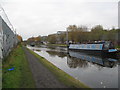
Tipton Mooring
by Gordon Griffiths geograph for square SO9592 The view of the Birmingham Canal in Tipton.
Tags:
canal:BirminghamX
region:Black CountryX
subject:Canal TowpathX
top:CanalsX
type:GeographX
NarrowboatX
place:Tipton
|

|
Network Explorer
by Gordon Griffiths geograph for square SO9492 The view near the Bean Road Industrial Estate on the Birmingham Canal in Tipton.
|

|
Derelict Factory
by Gordon Griffiths geograph for square SO9492 The view into the Bean Road Industrial Estate across the Birmingham Canal in Tipton.
Tags:
canal:BirminghamX
region:Black CountryX
Derelict BuildingX
Derelict FactoryX
place:DudleyX
type:GeographX
subject:Industrial SiteX
top:IndustryX
place:Tipton
|

|
Brum Canal Bend
by Gordon Griffiths geograph for square SO9492 The view near the Bean Road Industrial Estate on the Birmingham Canal in Tipton.
|

|
Canal Scene
by Gordon Griffiths geograph for square SO9492 The view near the Bean Road Industrial Estate on the Birmingham Canal in Tipton.
Tags:
canal:BirminghamX
region:Black CountryX
subject:Canal TowpathX
top:CanalsX
place:DudleyX
type:GeographX
place:Tipton
|

|
Wednesbury Oak Scene
by Gordon Griffiths geograph for square SO9694 The view of the path towards Wednesbury Oak Road in Tipton, West Midlands.
|

|
School Path
by Gordon Griffiths geograph for square SO9694 The view of Wednesbury Oak Primary School in Tipton, West Midlands.
Tags:
region:Black CountryX
top:Educational SitesX
type:GeographX
Primary SchoolX
place:SandwellX
subject:SchoolX
place:Tipton
|

|
Asda Scene
by Gordon Griffiths geograph for square SO9694 The view of the supermarket in Tipton, West Midlands.
Tags:
supermarket:ASDAX
region:Black CountryX
top:Business, Retail, ServicesX
type:GeographX
place:SandwellX
subject:SupermarketX
place:Tipton
|

|
Oval Road Scene
by Gordon Griffiths geograph for square SO9592 The view in Tipton, West Midlands.
Tags:
region:Black CountryX
type:GeographX
subject:Housing EstateX
place:SandwellX
Street SceneX
top:Suburb, Urban FringeX
place:Tipton
|

|
Oval Road View
by Gordon Griffiths geograph for square SO9592 The view in Tipton, West Midlands.
Tags:
region:Black CountryX
type:GeographX
subject:Housing EstateX
place:SandwellX
Street SceneX
top:Suburb, Urban FringeX
place:Tipton
|

|
Oval Road
by Gordon Griffiths geograph for square SO9592 The view in Tipton, West Midlands.
Tags:
region:Black CountryX
type:GeographX
subject:Housing EstateX
place:SandwellX
Street SceneX
top:Suburb, Urban FringeX
place:Tipton
|

|
Oval Road Bend
by Gordon Griffiths geograph for square SO9592 The view in Tipton, West Midlands.
Tags:
Bend in RoadX
region:Black CountryX
type:GeographX
subject:Housing EstateX
place:SandwellX
Street SceneX
top:Suburb, Urban FringeX
place:Tipton
|

|
Summerhill School
by Gordon Griffiths geograph for square SO9592 The view of the Primary School off Central Avenue in Tipton, West Midlands.
Tags:
region:Black CountryX
top:Educational SitesX
type:GeographX
Primary SchoolX
place:SandwellX
subject:SchoolX
place:Tipton
|

|
Belmont Close
by Gordon Griffiths geograph for square SO9692 The view of the Close in Tipton, West Midlands.
Tags:
region:Black CountryX
CloseX
type:GeographX
subject:Housing EstateX
place:SandwellX
Street SceneX
top:Suburb, Urban FringeX
place:Tipton
|

|
Ivy Road
by Gordon Griffiths geograph for square SO9593 The view in Tipton, West Midlands.
Tags:
region:Black CountryX
type:GeographX
subject:Housing EstateX
place:SandwellX
Street SceneX
top:Suburb, Urban FringeX
place:Tipton
|

|
Chestnut Avenue View
by Gordon Griffiths geograph for square SO9593 The view in Tipton, West Midlands.
Tags:
region:Black CountryX
type:GeographX
subject:Housing EstateX
place:SandwellX
Street SceneX
top:Suburb, Urban FringeX
place:Tipton
|

|
Central Avenue View
by Gordon Griffiths geograph for square SO9593 The view in Tipton, West Midlands.
Tags:
AvenueX
region:Black CountryX
type:GeographX
subject:Housing EstateX
place:SandwellX
Street SceneX
top:Suburb, Urban FringeX
place:Tipton
|

|
Warren Close
by Gordon Griffiths geograph for square SO9693 The view in Tipton, West Midlands.
Tags:
region:Black CountryX
CloseX
type:GeographX
subject:Housing EstateX
place:SandwellX
Street SceneX
top:Suburb, Urban FringeX
place:Tipton
|

|
Upper Church Lane View
by Gordon Griffiths geograph for square SO9693 The view in Tipton, West Midlands.
Tags:
region:Black CountryX
type:GeographX
subject:LaneX
place:SandwellX
Street SceneX
top:Suburb, Urban FringeX
place:Tipton
|

|
Upper Church Lane Path
by Gordon Griffiths geograph for square SO9693 The view in Tipton, West Midlands.
|

|
Central Avenue Steps
by Gordon Griffiths geograph for square SO9592 The view in Tipton, West Midlands.
|

|
Belmont Close Path View
by Gordon Griffiths geograph for square SO9592 The view in Tipton, West Midlands.
|

|
Robert Road
by Gordon Griffiths geograph for square SO9592 The view in Tipton, West Midlands.
Tags:
region:Black CountryX
type:GeographX
subject:RoadX
place:SandwellX
Street SceneX
top:Suburb, Urban FringeX
place:Tipton
|

|
Central Avenue
by Gordon Griffiths geograph for square SO9592 The view in Tipton, West Midlands.
Tags:
subject:AvenueX
region:Black CountryX
type:GeographX
place:SandwellX
Street SceneX
top:Suburb, Urban FringeX
place:Tipton
|

|
Summerfield Road
by Gordon Griffiths geograph for square SO9593 The view towards St Johns Road in Tipton, West Midlands.
Tags:
region:Black CountryX
type:GeographX
subject:Housing EstateX
place:SandwellX
Street SceneX
top:Suburb, Urban FringeX
place:Tipton
|

|
Salter Road
by Gordon Griffiths geograph for square SO9593 The view in Tipton, West Midlands.
Tags:
region:Black CountryX
type:GeographX
subject:RoadX
place:SandwellX
Street SceneX
top:Suburb, Urban FringeX
place:Tipton
|

|
Salter Road Junction
by Gordon Griffiths geograph for square SO9593 The view of the junction with Central Avenue in Tipton, West Midlands.
Tags:
region:Black CountryX
type:GeographX
subject:Road JunctionX
place:SandwellX
Street SceneX
top:Suburb, Urban FringeX
place:Tipton
|

|
Sycamore Road Junction
by Gordon Griffiths geograph for square SO9593 The view of the junction with Central Avenue in Tipton, West Midlands.
Tags:
region:Black CountryX
type:GeographX
subject:Road JunctionX
place:SandwellX
Street SceneX
top:Suburb, Urban FringeX
place:Tipton
|

|
Sycamore Road Bend
by Gordon Griffiths geograph for square SO9593 The view in Tipton, West Midlands.
Tags:
Bend in RoadX
region:Black CountryX
type:GeographX
subject:Housing EstateX
place:SandwellX
Street SceneX
top:Suburb, Urban FringeX
place:Tipton
|

|
Sycamore Road Scene
by Gordon Griffiths geograph for square SO9593 The view in Tipton, West Midlands.
Tags:
region:Black CountryX
type:GeographX
subject:Housing EstateX
place:SandwellX
Street SceneX
top:Suburb, Urban FringeX
place:Tipton
|

|
Fern Avenue
by Gordon Griffiths geograph for square SO9593 The view from Laurel Road in Tipton, West Midlands.
Tags:
region:Black CountryX
type:GeographX
subject:Housing EstateX
place:SandwellX
Street SceneX
top:Suburb, Urban FringeX
place:Tipton
|

|
Laurel Road
by Gordon Griffiths geograph for square SO9593 The view in Tipton, West Midlands.
Tags:
region:Black CountryX
type:GeographX
subject:Housing EstateX
place:SandwellX
Street SceneX
top:Suburb, Urban FringeX
place:Tipton
|

|
Ivy Road Scene
by Gordon Griffiths geograph for square SO9593 The view in Tipton, West Midlands.
Tags:
region:Black CountryX
type:GeographX
subject:Housing EstateX
place:SandwellX
Street SceneX
top:Suburb, Urban FringeX
place:Tipton
|

|
Ivy Road View
by Gordon Griffiths geograph for square SO9593 The view in Tipton, West Midlands.
Tags:
region:Black CountryX
type:GeographX
subject:Housing EstateX
place:SandwellX
Street SceneX
top:Suburb, Urban FringeX
place:Tipton
|

|
Ivy Road
by Gordon Griffiths geograph for square SO9593 The view in Tipton, West Midlands.
Tags:
region:Black CountryX
type:GeographX
subject:Housing EstateX
place:SandwellX
Street SceneX
top:Suburb, Urban FringeX
place:Tipton
|

|
Sycamore Road
by Gordon Griffiths geograph for square SO9593 The view in Tipton, West Midlands.
Tags:
region:Black CountryX
type:GeographX
subject:Housing EstateX
place:SandwellX
Street SceneX
top:Suburb, Urban FringeX
place:Tipton
|

|
Tozer Street
by Gordon Griffiths geograph for square SO9593 The view from St Johns Road in Tipton, West Midlands.
Tags:
region:Black CountryX
type:GeographX
subject:Housing EstateX
place:SandwellX
Street SceneX
top:Suburb, Urban FringeX
place:Tipton
|

|
Turner Street
by Gordon Griffiths geograph for square SO9593 The view from St Johns Road in Tipton, West Midlands.
Tags:
region:Black CountryX
type:GeographX
subject:Housing EstateX
place:SandwellX
Street SceneX
top:Suburb, Urban FringeX
place:Tipton
|

|
Field Road View
by Gordon Griffiths geograph for square SO9693 The view in Princes End, Tipton.
Tags:
region:Black CountryX
type:GeographX
place:SandwellX
subject:StreetX
Street SceneX
top:Suburb, Urban FringeX
place:Tipton
|

|
John Stokes Ltd
by Gordon Griffiths geograph for square SO9593 The view of the works on the A4037 road in Tipton.
|