
|
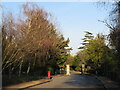
Entrance gates, South Hill Estate, near Harrow
by Malc McDonald
geograph for square TQ1486
South Hill Estate is a private residential estate near Harrow, in the outer... (more)
|

|
Rose Walk, Webb Estate, near Purley
by Malc McDonald
geograph for square TQ3061
A gate at the entrance to Rose Walk on the private Webb Estate.
|
|
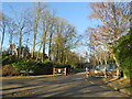
Silver Lane, near Purley
by Malc McDonald
geograph for square TQ3061
Silver Lane forms part of the Webb Estate, a private residential estate near... (more)
|

|
Southfield Place, Weybridge
by Malc McDonald
geograph for square TQ0763
Southfield Place is a private road on the outskirts of Weybridge, in Surrey.
|

|
Upper Woodcote Village, near Purley
by Malc McDonald
geograph for square TQ2961
Upper Woodcote Village is the name of the green on the Webb Estate, a private... (more)
|

|
Seymour Road, Buntingford
by Malc McDonald
geograph for square TL3530
Seymour Road is a private road in a modern housing development on the outskirts... (more)
|

|
Gate on the Webb Estate near Purley
by Malc McDonald
geograph for square TQ3061
An entrance gate on The South Border, a road leading into the Webb Estate in... (more)
|

|
Swissland Hill, Dormans Park near East Grinstead
by Malc McDonald
geograph for square TQ3940
Swissland Hill in Dormans Park estate, a private housing estate in Surrey.... (more)
|
|
Silver Lane, near Purley
by Malc McDonald
geograph for square TQ2961
A gate on Silver Lane, part of the Webb Estate in the outer suburbs of south London.
|

|
Nevill Court, near Tunbridge Wells
by Malc McDonald
geograph for square TQ5638
Nevill Court is a private road in a residential estate on the outskirts of... (more)
|

|
Homesteads Private Estate
by Des Blenkinsopp
geograph for square TQ5793
A sizeable neighbourhood of prosperous housing along private roads.
|

|
Lodge Road, Sundridge, near Bromley
by Malc McDonald
geograph for square TQ4170
Lodge Road is a privately-owned road in Sundridge, near Bromley in the outer... (more)
|

|
South Approach, Moor Park
by Marathon
geograph for square TQ0892
The Moor Park Estate is around six square miles in size, with gated, private... (more)
|

|
South Approach, Moor Park
by Marathon
geograph for square TQ0892
South Approach, Moor Park
The Moor Park Estate is around six square miles in... (more)
|

|
Lodge Road, Sundridge, near Bromley
by Malc McDonald
geograph for square TQ4070
Lodge Road is a privately-owned and privately-maintained road in Sundridge, near... (more)
|

|
Lodge Road, Sundridge, near Bromley
by Malc McDonald
geograph for square TQ4170
Lodge Road is a privately-owned road in Sundridge, near Bromley in the outer... (more)
|

|
Lodge Road, Sundridge, near Bromley
by Malc McDonald
geograph for square TQ4170
Lodge Road is a privately-owned road in Sundridge, near Bromley in the suburbs... (more)
|

|
Private jetty, Port La Salle, Bouldnor
by Paul Coueslant
geograph for square SZ3790
A public path runs through the estate from the main Yarmouth road.
|

|
Slipway and sea wall near Bouldnor
by Paul Coueslant
geograph for square SZ3690
The tiny piece of land in the south-east corner of this square, with the... (more)
|

|
Houses on Lawn Road, Rowley Park Estate, Stafford
by Rod Grealish
geograph for square SJ9122
There is a mixture of modern and older houses on Lawn Road. The metal fencing on... (more)
|

|
The Haydens
by Marathon
geograph for square TQ5947
The Haydens is a very upmarket housing development in North Tonbridge, south of... (more)
|

|
The Haydens
by Marathon
geograph for square TQ5947
The Haydens is a very upmarket housing development in North Tonbridge, south of... (more)
|

|
Junction of Barnoldby Road and Birkdale
by Martin Dawes
geograph for square TA2503
A large housing development to the north of the main road. Waltham like many... (more)
|