Is YOUR country at risk from El Niño? Maps plot the regions most likely to be affected by floods and extreme weather
- El Niño - a heating of sea temperatures in the Pacific - affects winds and can trigger both floods and droughts
- Scientists have now mapped how flood risks change when an El Niño and its opposite, La Niña, hit the oceans
- They found 44 per cent of river basins around world saw changes in 100-year flood risks during these events
- Biggest increases in flood risk were found in southwest US, parts of southern South America and Horn of Africa
- But it also found that the Sahel region of Africa and most of Australia saw the biggest decreases in flood risks
Warm water is brewing in the Pacific, resurrecting claims that a much-anticipated El Niño may be on its way.
El Niño - a heating of sea-surface temperatures in the Pacific - affects wind patterns and can trigger both floods and droughts in different parts of the globe.
Now, for the first time, scientists have mapped how flood risks change across the world when an extreme El Niño hits the oceans.
Scroll down for video

For the first time, scientists have mapped how flood risks change when an extreme El Niño hits the oceans. Pictured is the percentage of land experiencing changes in flood volume with return periods of 100 years, during El Niño years (top) and La Niña years (bottom)
Their study shows how some areas are exposed to dangerous floods that can damage buildings, put people's lives at danger, while other areas get a reprieve from drought.
'A lot of scientific effort has been put into modelling physical hazards themselves,' Philip Ward, who led the new study told Discovery News.
'Only much more recently have we started looking at the damage and being able to model that damage.'
According to a report by Roz Pidcock at Carbon Brief, the latest map was created using detailed hydrological models.

Pictured is the percentage of land experiencing changes in economic damages during El Nino years (top) and La Nina years (bottom). In El Niño years, 10 per cent of the globe sees higher than normal damages, while 19 per cent sees lower than normal
Researchers at Amsterdam's Global Change Institute compared the amount of flooding in El Niño and La Niña years to the average from all years between 1958 to 2000.
The study also looked at its opposite phase, La Niña, which occurs when winds in the equatorial Pacific causes a shift to cooler than normal ocean temperatures.
It found that 44 per cent of river basins around the world saw changes in 100-year flood risks during El Niño or La Niña years.
In one map, around 34 per cent of the world's land area experiences a change in the amount of flooding in El Niño years, compared to 38 per cent in La Niña years.
The biggest increases in flood risk were found in southwest United States, parts of southern South America and the Horn of Africa.
Meanwhile, the Sahel region of Africa and most of Australia saw the biggest decreases in flood risks.
The researchers also looked at how the weather pattern cause economic damage caused by flooding.
In El Niño years, 10 per cent of the globe sees higher than normal damages, while 19 per cent sees lower than normal.
The red colour in the map below shows regions where flooding decreases in El Niño or La Niña years. A darker the red, the lower the risk compared to normal.
'There have been studies [showing] that some areas get more rainfall during El Niño years, but more rainfall doesn't necessarily mean more floods,' Professor Ward said.
'So we're looking at the actual flooding and damages caused by flooding.'
These don't always match an increase in rainfall. For instance, the southeast of the US is often cooler and wetter during an El Niño, but the impact of flooding as a whole wasn't severe.
Scientists recently suggested that Ecuador is about to be hit by eastward-moving waves of warm water, suggesting that El Niño may be on its way.
The most recent waves increase the chances that parched California could be in for some relief - albeit small - if weather patterns take a turn later this year.
But Nasa has warned that 'fickle' El Niño will likely be weak if it does appear, providing only limited relief for a drought-ridden west coast.


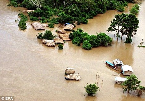
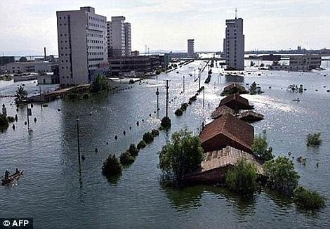
Strong El Niño events occur every 20 years or so. On the left, the village of Puerto Maldonado, Peru, is seen flooded in January 2003 as a result of El Niño rains, which drove 16,000 people from their homes. The worst El Niño on record in 1997 to 1998 was blamed for massive flooding along China's Yangtze river, right, that killed over 1,500 people

Kelvin waves of high sea level (red/yellow) are seen crossing the Pacific Ocean at the equator. The waves may be due to El Niño events. Green indicates normal sea level, and blue/purple areas are lower than normal
Most watched News videos
- Fatal Christmas crash plane's terrible nose dive before crashing
- Passenger on Azerbaijan flight sends wife video moments before crash
- Wild video shows 'UFO' accelerating instantly in New Jersey
- Cop walks past woman set on fire on subway as suspect watches
- Horrific moment plane with 72 onboard crashes in Kazakhstan
- Drunk Brit woman fights police in Thailand streets on Christmas
- Teenage girl washed away by wave while taking selfie in Indonesia
- MAGA candidate shares shocking video of 'migrant execution'
- King and family arrive for Christmas service at Sandringham
- Shocking footage shows miracle survivors of devastating plane crash
- Did Russians shoot down jet that crashed and killed 42?
- Teamsters boss blows the lid on Kamala Harris


Is this supposed to be a story'???
by Jonah 21