

Rapids between cypress knees? That’s what you’ll see along the loop around Camp Branch when “surf’s up” along the Suwannee after a good rain.
This region has spectacular geology thanks to its karst topography. Karst occurs when water and mild acid from tree leaves and other natural detritus seeps into porous rock.
 A karst window adjoins the campsite
West of White Springs, Camp Branch tumbles through a narrow gorge over a series of cascades and vanishes into a sinkhole.
Its waters emerges as a spring in the Suwannee River just as invisibly.
The 3.6 mile Disappearing Creek Loop has a loop within a loop, the outer third of which is a scenic stretch of the Florida Trail on the river bluffs.
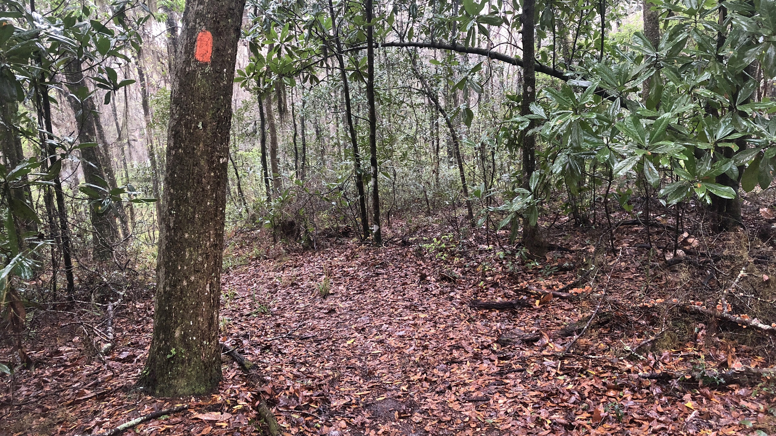
 Along the bluffs of the Suwannee on the Florida Trail
Our Florida Trail Books & Guides


Disclosure: As authors and affiliates, we receive earnings when you buy through our links. This helps us provide public information on this website.
Overview
Location: White Springs
Length: 3.6 miles
Trailhead: 30.3778, -82.8789
Address: SE 89th Way, White Springs
Fees: Free
Restroom: None
Land manager: Suwannee River Water Management District
Phone: 386-362-1001
Trailhead open dawn to dusk. No camping at the trailhead. Camp at a designated campsite near the Florida Trail.
Leashed dogs are welcome, but we caution against bringing them on the inner loop due to the steepness of the terrain. The same goes for small children. If you have balance issues, this isn’t a trail for you.
Do not hike into any flowing water on this loop. If the Suwannee or Camp Branch is flooding, water rises through surrounding sinkholes, making the landscape treacherous.
Directions
30.3778, -82.8789
From White Springs, follow US 41 north past the gate of Stephen Foster Folk Culture State Park. Turn left on CR 25A. Drive 8 miles. CR 25A crosses an overpass over Interstate 75. The turnoff is on the left onto a narrow double-track single lane road signposted SE 89th Way. Follow it a quarter mile, with a sharp jog left and a steep descent to the trailhead.
Hike
A map at the trailhead kiosk gives an overview of the route. From the gap in the trailhead fence, take the graveled double-track access road behind the gate.
It makes a rapid steep, deep plunge into a ravine created by a side channel eroding its way to the twists and turns of Camp Branch through a bluff forest.
 Start by dipping through a ravine
After the substantially steep climb out of the ravine, the road levels out. With shiny leaves looking much like rhododendron, horsesugar greens up the edges.
This upland forest is relict sandhill, oaks and pines ravaged and thinned by recent hurricane seasons, the understory a thick puzzle of textures.
 Horsesugar beyond the crest of the ravine
White blazes provide confidence markers along the curving forest road. Deer moss sprouts in seafoam-colored puffs on a leafy sandbank.
A brief ascent into a curve is followed by a descent through tufted grasses. Buried under the road at 0.6 mile, a culvert conveys an intermittent stream.
 Among pines and oaks
Graze close to a property line marked by a fence before the understory opens up beneath the pines. A soft fog often lies across this landscape on cool mornings.
Climb through a curve to a junction with a double white blaze. Although the worn two-track curves sharply right, continue straight ahead into a broad clearing.
 Continue straight ahead instead of curving
At treeline, a narrow, leafy path wiggles through an unfortunate collection of downed trees, one of which sports a blue blaze for this short connector.
Meet the Florida Trail at a T intersection, turning right at 0.8 mile to join its footpath.
 Trail junction
Heavily decorated with Spanish moss, the dense river bluff forest has a haunting feel. For the next tenth of a mile there is a lot of damage to the forest.
Follow a grassy ribbon between the trees, using the orange blazes as a guide when it isn’t obvious where to turn next.
 Seepage slope
A seepage spring creates a soggy, muddy spot at one grassy uphill curve. It’s a relief to exit the corridor of the worst of the crumpled, chainsawed trees.
Thickly carpeted with pine needles, the footpath curves past a dropoff into a large forested sinkhole. The curving continues, mimicking an unseen curve of the river.
 Forested sinkhole
Climb into a corridor defined by an expanse of saw palmetto under the oaks. Open sky on the left makes it obvious the river isn’t far.
At a mile, grab a glimpse of the frothy waters through a screen of trees. In another tenth of a mile, descend to a low clearing with a blazed tree in its middle.
 Worn pathway
Make a left on a spur trail to climb over the river bluff, a ribbon of sandy beach along swift, tannic waters your introduction to the Suwannee River.
As obvious on its far shore, eroded rocky bluffs are the norm for this floodplain river, which drains the Okefenokee Swamp and hundreds of springs to the Gulf of Mexico.
 Beach on the Suwannee River
Return to the Florida Trail to continue your journey. Climbing out of the depression, the trail corridor broadens.
A double blaze marks a sharp left dropping between walls of saw palmetto. Edging towards the bluffs again, glimpse the river from spots where fronds frame the view.
 River view
Sand banks are now obvious on the far shore by how they gleam in the light. Building up along curves, they come and go at the whim of the floodwaters.
Following the gentle curves of the trail, pass low depressions and make short climbs through the undulating terrain of the river bluff forest.
 Curve in the trail
Along with the understory itself, more views of the river open up by 1.5 miles. Rejoin the palmetto-lined corridor, reaching another spur trail at 1.7 miles.
Its furrowed approach to the river bank makes it a good stop for backpackers to filter water before reaching the designated campsite ahead.
 Side path to river level
The footpath broadens to a width of a road before it meets the well-signposted junction for Disappearing Creek.
Turn right, leaving the Florida Trail behind at 1.8 miles to walk towards the campsite.
 Trail junction
On the blue blazed trail, its benches and fire ring are perched on a natural crown above a steep dropoff into inky waters at the bottom of a sinkhole.
Follow the worn path edging around this gaping pit, with better views into it on the climb along its edge.
 Entry to the campsite and south approach to the loop
Continue up and over a ridge and into a depression with numerous depressions in its floor.
The blue blazes lead up a sandy slope covered in leaves to what looks like a puzzle of rock beyond a bluff. Approach it slowly.
 Climbing towards the bluff
The dropoff and the waterfall beyond it aren’t obvious until you reach the edge of the bluff. Camp Branch pours towards you through the rocky chasm straight ahead.
Its origins remain unseen from this angle as it cascades into a swirling current that simply vanishes below your feet.
This is the south end of the inner blue-blazed loop that traces its journey upstream.
 Camp Branch cascading to where it disappears
Turn right, walking around the oddly shaped oak to follow the narrow footpath along the chasm.
Pause to look back to see the tea-colored pool where the creek vanishes into a rocky bluff in a layer of foam.
This karst formation is called a swallet, a sinkhole that gulps a waterway directly into the aquifer.
 The swallet that disappears the creek
The footpath climbs as it traces the deep cleft beside it, with views of the water racing through and over the rocks, foamy after it burbles through narrow cascades.
Over the years, the trail has been nudged away from the eroding sides for safety’s sake, so there are multiple parallel footpaths in several spots.
 The upper cascades into the narrow gorge
Cypress trees rise from the upper reaches of the creek, with oaks closer to the path. Note the watermarks on them.
When the Suwannee rises in response to heavy rains upstream, the aquifer does as well, filling this entire gorge with water.
 Watermarks climb ten feet high or more
Descending an extremely narrow and canted sandy path, approach and cross a simple plank footbridge with a single railing.
At 2.1 miles, it hovers well over Camp Branch, with a very steep scramble up the bluff on the other side to continue along the loop.
 Footbridge with one railing
A brief walk in the woods opens to the flatter floodplain on this side of the creek, still elevated on a bluff.
Walking downstream, follow the narrow footpath as it guides you through a different set of views.
 Drawing close to Camp Branch in its floodplain
Tannic waters sluice through the teeth of cypress knees into curves that appear more sinuous from this angle.
Once the stream drops into its chasm, it’s no longer visible.
Clamber over a limestone ridge, blue blazes leading back around to the start of the loop on the bluff above the swallet.
 At lower water levels, the creek cascades through the knees
At 2.3 miles, continue past the odd tree and climb the path straight up the hill beyond it, which curves and broadens before reaching a T junction.
At the clearing with the forest road connecting the trailhead and the river, turn left.
 Follow the path straight up the bluff to exit the loop
The remainder of the hike is simply a walk along the forest road back to the trailhead. White blazes appear once more.
There is a slow ascent from river bluff forest into the relict sandhills with their pines and oaks.
 Forest road heading back to Camp Branch trailhead
Within a tenth of a mile, a double blaze marks a turn in the road where you might otherwise be tempted to take a path straight ahead.
Older sand live oaks lend character to this corner of the forest before a short climb. More ascents follow, the road becoming grassier underfoot.
 Grassy curve
A patch of horsesugar draws attention to the understory just before the junction at 2.9 miles where you close the outer loop.
Follow the curve to the left, retracing the start of the hike to the plunging ravine and steep climb, reaching the trailhead at 3.6 miles.
 Moses and lichens on sand live oaks
Trail Map

Explore More!
Learn more about the Suwannee section of the Florida Trail
 Florida Trail, Suwannee For 78 miles along the Suwannee River, the Florida Trail clings to bluffs and scrambles through ravines for physical challenges and great scenery.
Video
Hiking Disappearing Creek Loop
Slideshow
See our photos from the Disappearing Creek Loop
Nearby Adventures
 Florida Trail, Camp Branch to Suwannee Springs 7.8 miles. Rugged climbs through abandoned river channels and along the highest elevations along the Suwannee River make this hike a roller-coaster through river bluff forests and sandy beaches.
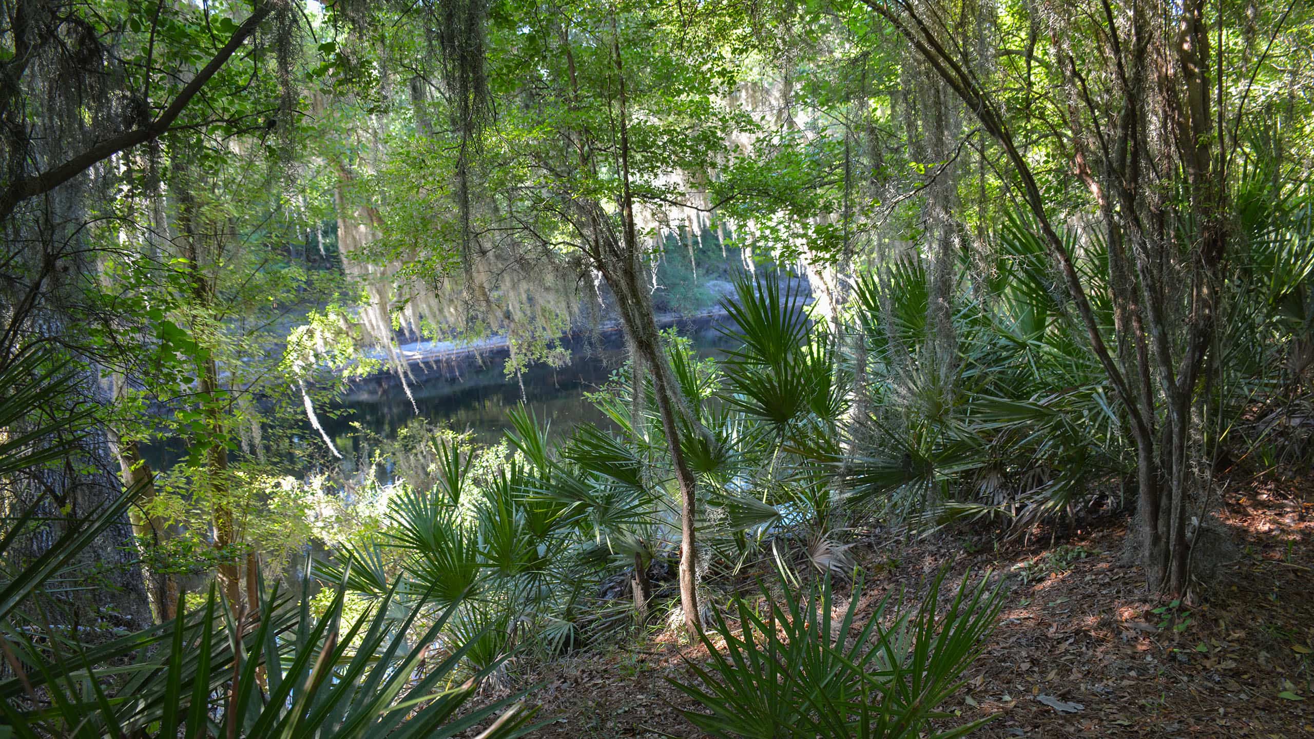 Florida Trail, Stephen Foster to CR 25A 4.7 miles. Roly-poly and rugged, the Florida Trail across Stephen Foster Folk Culture Center State Park showcases the beauty of the Suwannee River from its bluffs.
 Stephen Foster Folk Culture Center State Park At Stephen Foster Folk Culture Center State Park, Florida pioneer crafts and Florida folk music are as important as the lovely setting on the Suwannee River.
 Florida Trail, White Springs 3.6 miles. Spanning from one end of White Springs to the other along a bend in the Suwannee River, this Florida Trail segment is an easy day hike through a historic community.
- Brooker Creek Preserve - April 20, 2025
- Disappearing Creek Loop - April 9, 2025
- Tippecanoe Environmental Park - April 3, 2025