

An easy walk in the woods from either trailhead provides access to one of the most popular destinations along the Cross Florida Greenway, the Land Bridge.
From Interstate 75, it looks somewhat odd, topped with trees, and is certainly a notable landmark for visitors driving south through Ocala.
But America’s first Land Bridge is only one of the highlights of this short but scenic section of trail.
Major terrain changes come from the piles left behind – and now carpeted with scrub forest – during the digging of two different canals in two different eras.
Mushrooms flourish in the damp leaf litter during the fall months, and orchids bloom each summer. But it’s the ancient oaks that capture the glory of the forest.

Our Florida Trail Books & Guides


Disclosure: As authors and affiliates, we receive earnings when you buy through our links. This helps us provide public information on this website.
Overview
Location: Ocala
Length: 3.6 miles linear
Trailhead: 29.040913, -82.201004
Fees: Free
Restroom: at both trailheads
Land manager: Cross Florida Greenway
Phone: 352-236-7143
Leashed dogs welcome. The trail crosses a paved bike path. Watch out for cyclists whizzing past. The Florida Trail shares the paved bike path as it crosses the Land Bridge.
If you are backpacking, contact the Cross Florida Greenway for a free permit. There are two designated campsites along this section.
Florida Trail members do not need a permit to camp along the Cross Florida Greenway if carrying their Florida Trail membership card, but in this urban corridor, it’s safer if you check in and let them know your camping plans.
Directions
29.059735, -82.154948
29.040913, -82.201004
SW 49th Ave Trailhead: From Interstate 75 Belleview/Dunnellon Exit 324, head west on CR 484 for 2.3 miles. Turn right on Marion Oaks Course at the traffic light. Follow it 0.8 miles as it curves and becomes Marion Oaks Trail. Turn right onto SW 49th Ave and continue 0.4 mile to the trailhead on the right.
Land Bridge Trailhead: Along CR 475A 2 miles north of CR 484 off the I-75 exit for Belleview / Dunnellon. Head east from I-75 to the first traffic light, turn left and drive north. The trailhead entrance has a turnout lane. Drive past the equestrian parking area and around to the large parking area near the restrooms.
Hike
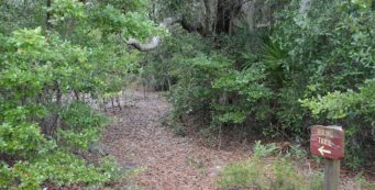
At the SW 49th Avenue trailhead, enter the gate and stay to the right of the paved bike path to find the footpath. It descends through the pines before crossing the main paved bike path.
Just after this crossing is the junction with the Florida Trail at a sign. Turn right.
Beyond a tunnel of pines, a steep climb awaits. At the top, a designated primitive campsite sits on the flat hilltop surrounded by pines. It’s down a short blue blaze.
The orange blazes lead to a plateau of sandhill habitat, where turkey oaks show off blazing colors in the fall.

After a mile, cross the paved bike path, and after a short stretch through the pines, cross it again. The remains of a building foundation sit in a clearing.
Taller longleaf pines surround the trail, with sand pines creeping in from the surrounding scrub forest.
Tall sand pines top a dense understory of young scrub where the trail ascends and descends hidden terraces within the old canal diggings.
At a bench, take the time to follow the side path downhill. It steeply descends the bluff and crosses the paved bike path and a horse trail.
In front of you is a massive sand dune sweeping towards the sky. This is the most showy bit of erosion along the length of the Cross Florida Greenway.
It was created by crews hand-digging a canal across Florida during the Great Depression. One of the horse trails climbs the dune and you can, too.

Return to the bench to continue northbound on the Florida Trail. It emerges at the paved bike path.
There is a kiosk and a watering trough for horses (useful in a pinch for hikers who need to filter water) within sight of the Land Bridge.
It’s here that all four trails meet – mountain bike, carriage, equestrian, and hiking – and according to the game cameras, wildlife uses it to cross the interstate too.

Peek down and wave to the traffic through the two portals along this giant planter that spans the interstate.
Walking down the paved slope to the next trail junction, you’ll find pathways headed every which way.
The orange blazes lead northwest into the woods at 10-o-clock from the bench.
Behind the kiosk at the bench is a blue-blazed footpath that marks the original Florida Trail route on the Greenway. It provides a different route to the Land Bridge trailhead.
The scrub forest here is denser than the one on the other side of the bridge, with taller oaks and sand pines.
Violet cort mushrooms grow in the leaf litter, and shelf fungi persist on fallen oak logs.

The older oaks are sand live oaks, and they grow to significant size in this forest. With each footfall, the sound of the traffic recedes.
A bench is provided at one intersection with an equestrian trail, where you can sit and enjoy the cool shade.
Rounding the corner of a ranch fence after it passes a side trail to a backpacker’s campsite, the trail meanders through a more open area before crossing the carriage road one last time.

This final half mile of trail showcases enormous live oaks that were once planted in a row, probably to mark a property boundary.
On the right is one that split apart but continues to grow. Another live oak reaches out with spider-like limbs, inviting an easy climb and a photo op.
Reaching the second junction with the blue-blazed trail, the Florida Trail emerges from the denser woods to the Land Bridge trailhead through a gap in the fence.
Within sight are horse corrals, picnic tables, the parking area, and restrooms. Northbound, the trail continues into the next segment by staying under the oaks.
NORTHBOUND: Land Bridge Trailhead to Santos
SOUTHBOUND: Ross Prairie to SW 49th Ave
 Florida Trail, Land Bridge Trailhead to Santos 6.7 miles. Between the Land Bridge Trailhead and Santos, the Florida Trail winds its way around horse farms to meander through stands of oaks and pines.
 Florida Trail, Ross Prairie to SW 49th Ave 6.5 miles. With hilly terrain to traverse past fern-covered boulders and large sinkholes beneath the pines, this is a rugged and interesting segment of the Florida Trail on the Cross Florida Greenway.
Suggested Articles
 Florida Trail Backpacking Backpackers will appreciate the many places the Florida Trail provides a pleasant overnight, three-day-weekend, or multi-day hiking experience to escape to the outdoors.
 Cross Florida Greenway History: Bridge to the Future The history of the Cross Florida Greenway's birth and the building the Land Bridge - and the Florida Trail - across this new stretch of public land in Central Florida in 1999.
 Cross Florida Greenway History: The Land Bridge A landmark along Interstate 75 near Ocala, the Land Bridge remains one of the more popular destinations for hikers, bikers, and equestrians on the Cross Florida Greenway.
 Explore More!
Learn more about the Cross Florida Greenway section of the Florida Trail
 Florida Trail, Cross Florida Greenway 43.8 miles. A prime destination for backpacking and day hiking south of Ocala, the Florida Trail follows the Cross Florida Greenway through woodlands between the Withlacoochee and Ocklawaha Rivers.
Slideshow
See our photos from this hike
Nearby Adventures
More worth exploring nearby
 Holly Hammock Hiking Trail A 2.4 mile loop showing off the habitat diversity of Ross Prairie State Forest, this easy hike provides scenic panoramas across the prairie on a mostly shaded trail.
 Sholom Park Privately owned, Sholom Park in Ocala is a place for meditative walking among gardens and a labyrinth along meandering trails through its well-manicured 45 acres.
Official Map (PDF) Interactive App Reserve a Campsite Official Website

- Brooker Creek Preserve - April 20, 2025
- Disappearing Creek Loop - April 9, 2025
- Tippecanoe Environmental Park - April 3, 2025