Burundi
News •
Burundi, country in east-central Africa, south of the Equator. The landlocked country, a historic kingdom, is one of the few countries in Africa whose borders were not determined by colonial rulers.
The vast majority of Burundi’s population is Hutu, traditionally a farming people. Power, however, has long rested with the Tutsi minority, which historically has controlled the army and most of the economy, particularly the lucrative international export of coffee. Few real cultural differences are distinguishable between the two peoples, and both speak Rundi (Kirundi). Such linguistic homogeneity is rare in sub-Saharan Africa and emphasizes the historically close cultural and ethnic ties among the peoples in Burundi.
- Head Of Government4:
- Prime minister: Gervais Ndirakobuca
- Capital:
- Gitega5
- Population:
- (2024 est.) 13,439,000
- Head Of State:
- President: Evariste Ndayishimiye3, assisted by Vice President: Prosper Bazombanza
- Form Of Government:
- republic with two legislative bodies (Senate [431]; National Assembly [1212])
- Official Languages:
- Rundi; French
- Official Religion:
- none
- Official Name:
- Republika y’u Burundi (Rundi); République du Burundi (French) (Republic of Burundi)
- Total Area (Sq Km):
- 27,834
- Total Area (Sq Mi):
- 10,747
- Monetary Unit:
- Burundi franc (FBu)
- Population Rank:
- (2023) 79
- Population Projection 2030:
- 13,123,000
- Density: Persons Per Sq Mi:
- (2024) 1,250.5
- Density: Persons Per Sq Km:
- (2024) 482.8
- Urban-Rural Population:
- Urban: (2024) 15.2%
- Rural: (2024) 84.8%
- Life Expectancy At Birth:
- Male: (2021) 62 years
- Female: (2021) 68 years
- Literacy: Percentage Of Population Age 15 And Over Literate:
- Male: (2021) 81%
- Female: (2021) 68%
- Gni (U.S.$ ’000,000):
- (2023) 3,033
- Gni Per Capita (U.S.$):
- (2023) 230
- Thirty-six seats are indirectly elected; additional seats are designated for the Twa ethnic group (3) and former presidents (4).
- Includes 21 appointed or co-opted seats.
- After the unexpected death of Pres. Pierre Nkurunziza on June 8, 2020, the inauguration of president-elect Evariste Ndayishimiye was moved up to June 18.
- The position of prime minister was reinstated under a 2018 constitutional amendment and was filled after the president elected in 2020 took office.
- The future move of the capital from Bujumbura to Gitega was announced by the president in March 2007. A law passed by Parliament in January 2019 and promulgated by the president the next month formally designated Gitega as the country’s political capital and Bujumbura as the economic capital. The government’s move to Gitega was expected to be concluded in or about 2022; as of September 2024, it was not complete.
Even so, ethnic conflict between the Hutu and Tutsi has plagued the country since it gained independence from Belgium in 1962, at a great cost in human life and property. Few Burundians escaped the ensuing anarchy into which the country was plunged when this interethnic violence flared anew in the 1990s, a bloody conflagration that well illustrated the Rundi proverb “Do not call for lightning to strike down your enemies, for it also may strike down your friends.” Neither the presence of an international peacekeeping force beginning in the late 1990s nor the ratification of an agreement to share power between Hutu and Tutsi were immediately effective in curbing interethnic violence, which also spilled into the neighbouring countries of Rwanda and the Democratic Republic of the Congo. Burundians are now faced with the task of quelling ethnic dissent, promoting unity, and rebuilding the country.
Burundi’s political capital, Gitega, is also its cultural capital, containing the national museum and several schools. Gitega lies in the center of the country, near the southernmost source of the Nile River and a spectacular waterfall, Chutes de la Kagera. The country’s largest city, Bujumbura, was the capital until 2019, at which point it was designed the economic capital. It lies at the northeastern end of Lake Tanganyika. The old section of the city comprises buildings from the German and Belgian colonial periods, as well as a central market filled with hundreds of vendors’ booths.
Land
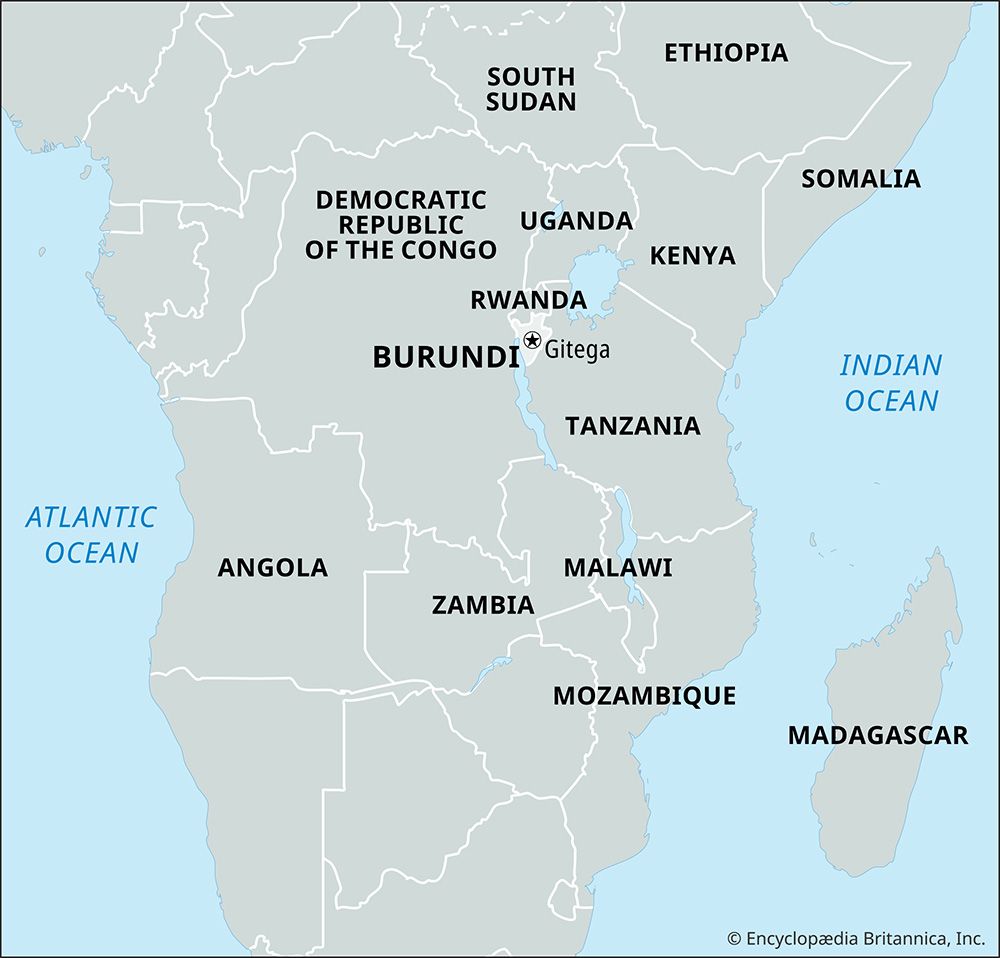
Burundi is bounded by Rwanda to the north, Tanzania to the east and south, Lake Tanganyika to the southwest, and the Democratic Republic of the Congo to the west.

Relief and drainage
Burundi’s topography includes the eastern flank of the Western Rift Valley. A chain of mountains and high plateaus formed from ancient Precambrian rock rises to 9,055 feet (2,760 metres) at Mount Heha, the country’s highest point. In the northwest the narrow Imbo valley extends southward from Rwanda to Lake Tanganyika and includes the Rusizi River, which separates Burundi from the Democratic Republic of the Congo. Farther south and west, along the shores of Lake Tanganyika, the land rises steeply to form part of the Congo-Nile divide, which reaches elevations of 8,500 feet (2,600 metres). East of the divide, plateaus slope gently to elevations of 5,000–6,000 feet (1,500–1,800 metres) to the southeast; the Ruvyironza River flows northeast, cutting through the plateaus. A few valleys and shallow lakes occupy the northern frontier near Rwanda.
Soils
Light, forest-derived soils predominate, forming a thin layer of humus over lateritic (iron-rich) subsoils. The best soils are formed from alluvium, but they are confined primarily to the lower portions of larger river valleys. Soil erosion, caused by a combination of steep slopes and frequent rainfall, is a serious problem and creates a major constraint on agriculture; ironically, erosion is further exacerbated by the clearing of land for agricultural purposes.
Climate
Elevation is a major factor in Burundi’s climate, greatly moderating its tropical character. The country’s generally high elevation produces relatively cool temperatures, which average only about 70 °F (21 °C) throughout the year in the central plateau area and usually drop to below 60 °F (15 °C) at night. At lower elevations the annual average is only slightly higher—for example, at Bujumbura in the Imbo valley. Annual precipitation, which averages 60 to 70 inches (1,500 to 1,800 mm) in the highest-lying areas, is only about 40 inches (1,000 mm) on the shores of Lake Tanganyika. There is a short dry season from May to August.
Plant and animal life
The natural forest vegetation has almost entirely disappeared from the landscape and is limited now primarily to higher mountain slopes. On the plateaus, wooded savanna is found at higher elevations, giving way to more-open savanna on the lower slopes. Poaching has dealt a severe blow to the country’s wildlife. The elephant population has virtually disappeared, leaving only warthogs, baboons, and antelope as the less endangered species.
People
Ethnic groups
As in Rwanda, Tutsi and Hutu are the principal ethnic communities, with the Hutu constituting the overwhelming majority and the Tutsi a significant minority. Other groups include the Twa Pygmies and a sprinkling of Swahili-speaking peoples from Tanzania and the Democratic Republic of the Congo. Common perceptions of Tutsi as uniformly tall and graceful and of Hutu as short and stocky do not fit the reality of physical variations because the two groups have frequently intermarried over the centuries.
Traditionally, the Hutu have been farmers, while the Tutsi have been pastoralists. Some regional status differences exist among the Tutsi, with the Tutsi-Banyaruguru clan found primarily in the north of the country and the Tutsi-Bahima primarily in the south. Historically, the Tutsi-Banyaruguru generally dominated precolonial Burundi, while the Tutsi-Bahima have generally dominated Burundi since independence. Society was originally organized around family and clan loyalties. Beginning in the 16th century, these ties were adapted to include a Tutsi monarchy. Intervening between the king (mwami) and the masses was a princely class (ganwa) that kept the ordinary Tutsi and Hutu on equal footing. The relationship between the two groups began to change during the colonial period, when the German and Belgian colonial administrators favoured the Tutsi over the Hutu.


